Mulinu'u

Last updated
A historical photo of Mulinu'u showing oval Samoan fale (photo taken between 1893-1949). Mulinu'u by Tattersall Studios - Samoa 1893-1949.jpg
A historical photo of Mulinu'u showing oval Samoan fale (photo taken between 1893–1949).
Unveiling of the Anglo-American Monument at Mulinu'u (1900), with Mount Vaea, the burial place of Robert Louis Stevenson, in the background. Scene.on.the.Mulinu'u.Peninsula,Upolu.Andrew.Thomas 1900.jpg
Unveiling of the Anglo-American Monument at Mulinu'u (1900), with Mount Vaea, the burial place of Robert Louis Stevenson, in the background.

Mulinu'u is a small village situated on a tiny peninsula on Upolu island in Samoa. It became the site of the colonial administration in Samoa in the 1870s [1] and continues to be the site for the Parliament of Samoa. It is located on the central north coast of the island and is part of the urban area comprising Apia, the country's capital. [2]

Upolu island in Samoa

Upolu is an island in Samoa, formed by a massive basaltic shield volcano which rises from the seafloor of the western Pacific Ocean. The island is 75 kilometres long and 1,125 square kilometres in area, making it the second largest of the Samoan Islands geographically. With approximately 145,000 people, it is by far the most populated of the Samoan Islands. Upolu is situated to the southeast of Savai'i, the "big island". Apia, the capital, is in the middle of the north coast, with Faleolo International Airport at the western end of the island. The island has not had any historically recorded eruptions, although three lava flows date back only a few hundred to a few thousand years.

Samoa country in Oceania

Samoa, officially the Independent State ofSamoa and, until 4 July 1997, known as Western Samoa, is a country consisting of two main islands, Savai'i and Upolu, and four smaller islands. The capital city is Apia. The Lapita people discovered and settled the Samoan Islands around 3,500 years ago. They developed a unique Samoan language and Samoan cultural identity.

Legislative Assembly of Samoa Parliament of Samoa

The Legislative Assembly is the Parliament of Samoa based in the capital, Apia, where the country's central administration is situated.

Overview

Mulinu'u peninsula, where this and some other villages are situated, is the site of the Fale Fono or Parliament House in Samoa as well as the Lands and Titles Court. At the tip of the peninsula is the meteorology office which was initially established in the late 19th century as an observatory. The peninsula is also the site for several important tombs including that of the previous Head of State, Malietoa Tanumafili II.

Malietoa Tanumafili II Malietoa in Samoa

Malietoa Tanumafili II, also called Susuga, was the Malietoa, the title of one of Samoa's four paramount chiefs, and the head of state, or O le Ao o le Malo, a position that he held for life, of Samoa from 1962 to 2007. He was co-chief of state in 1962 and became the sole head of state on 15 April 1963. At the time of his death, he was the oldest national leader in the world. It is a common mistake that the Malietoa title is a title equivalent to a king-ship. Malietoa is known as the first warrior title, and is respected not as a King but as a Tamaaiga or Ao Mamalu ole Malo. He was the last incumbent president-for-life in the world.

The population of Mulinu'u village is 61 (2006 Census). It is part of Tuamasaga electoral district. [2]

Tuamasaga District in Samoa

Tuamasaga is a district of Samoa, with a population of 83,191. The geographic area of Tuamasaga covers the central part of Upolu island.

Related Research Articles

Tafua is a seaside village on the island of Savai'i in Samoa. It is situated on a peninsula on the southeast coast of the island in Palauli district. The population is 408.

Sataoa Village in Tuamasaga, Samoa

Sataoa is a small village situated on the central south coast of Upolu island in Samoa. Like many villages in the country, Sataoa has two settlements, one inland and one by the coast. The population of Sataoa Uta is 924 and Sataoa Tai is 320.

Leulumoega Village District in Aana, Samoa

Leulumoega Tuai is a village situated on the northwest coast Upolu island in Samoa. The village is part of the A'ana Alofi II Electoral Constituency which formas part of the larger A'ana political district.

Afega Village in Tuamasaga, Samoa

Afega is a village on the island of Upolu in Samoa. It is located on the central north coast of the island to the west of the capital Apia in the countryside. The population is 1,781.

Tuana'i is a small village on the central north coast of Upolu island in Samoa. It is situated to the west of Apia, the country's capital. The population is 1,247.

Moata'a is a village on the island of Upolu in Samoa. It is situated on the central north coast of the island, to the east of the capital Apia. The village is in the political district of Tuamasaga.

Sala'ilua is a village on the island of Savai'i in Samoa. It is situated on the south coast of the island in Palauli district.

Pesega is a village on the island of Upolu in Samoa. It is located on western outskirts of Apia, the country's capita. Pesega is part of Faleata West Electoral Constituency which forms part of the larger political district of Tuamasaga.

Siutu is a village on the island of Savai'i in Samoa. It is situated on the southeast coast of the island in Palauli district.

Safa'atoa is a village on the island of Upolu in Samoa. It is situated on the south west side of the island. Safa'atoa is in the electoral constituency of Lefaga & Falese'ela which forms part of the larger political district A'ana.

Matautu is a village in the large traditional settlement of Lefaga in Samoa. The village is situated on the south west coast of Upolu island and lies within the political district of A'ana.

Tanugamanono is a village on the island of Upolu in Samoa. It is situated on the north central side of the island near the country's capital Apia. The village is in the political district of Tuamasaga.

Vaimoso is a village on the island of Upolu in Samoa. It is situated on the north central side of the island near the country's capital Apia. The village is in the political district of Tuamasaga.

Lotopa is a village on the island of Upolu in Samoa. It is situated on the north central side of the island near the country's capital Apia. The village is in the political district of Tuamasaga.

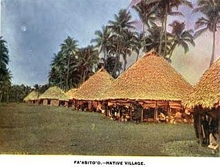
Fasito'o Tai is a village situated on the northwest coast of Upolu island in Samoa. The village is part of A'ana Alofi III Electoral Constituency which formas part of the larger A'ana political district.

Fasitoo Uta

Fasito'o Uta is a village situated on the northwest coast of Upolu island in Samoa. The village is part of A'ano Alofi I Electoral Constituency which forms part of the larger A'ana political district.

Luatuanu'u is a village situated on the east side of Upolu island in Samoa. The village is part of Anoamaa West Electoral Constituency which is within the larger political district of Atua.

Lepea

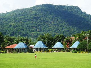
Lepea is a village on the island of Upolu in Samoa. The picturesque settlement of round Samoan houses built in a concentric pattern in large open grounds (malae) is situated 5mins drive west of the capital Apia on the north central coast of the island. It is part of the Tuamasaga electoral district.

References

  1. Meleisea, Malama (1987). The Making of Modern Samoa. University of the South Pacific. p. 54. ISBN   982-02-0031-8 . Retrieved 8 March 2010.
  2. 1 2 "Population and Housing Census Report 2006" (PDF). Samoa Bureau of Statistics. July 2008. Archived from the original (PDF) on 21 July 2011. Retrieved 19 December 2009.

Coordinates: 13°49′S171°47′W / 13.817°S 171.783°W / -13.817; -171.783

Geographic coordinate system Coordinate system

A geographic coordinate system is a coordinate system that enables every location on Earth to be specified by a set of numbers, letters or symbols. The coordinates are often chosen such that one of the numbers represents a vertical position and two or three of the numbers represent a horizontal position; alternatively, a geographic position may be expressed in a combined three-dimensional Cartesian vector. A common choice of coordinates is latitude, longitude and elevation. To specify a location on a plane requires a map projection.