Mundaring-Kalamunda Important Bird Area

Last updated

The IBA is an important area for long-billed black cockatoos Calyptorhynchus baudinii (female) -Margaret River-8.jpg
The IBA is an important area for long-billed black cockatoos

The Mundaring-Kalamunda Important Bird Area comprises a fragmented 137 km2 of land centred on the towns of Mundaring and Kalamunda in the Darling Scarp region of Western Australia. It lies inside, as well as adjacent to the Beelu National Park.

Mundaring, Western Australia Suburb of Perth, Western Australia

Mundaring is a suburb located 34 km east of Perth on the Great Eastern Highway. The suburb is located within the Shire of Mundaring.

Kalamunda, Western Australia Suburb of Perth, Western Australia

Kalamunda is a town and eastern suburb of Perth, Western Australia, located in the Darling Scarp at the eastern limits of the Perth metropolitan area.

Darling Scarp misnamed range, scarp east of Perth, Western Australia

The Darling Scarp, also referred to as the Darling Range or Darling Ranges, is a low escarpment running north-south to the east of the Swan Coastal Plain and Perth, Western Australia. The escarpment extends generally north of Bindoon, to the south of Pemberton. The adjacent Darling Plateau goes easterly to include Mount Bakewell near York and Mount Saddleback near Boddington. It was named after the Governor of New South Wales Lieutenant-General Ralph Darling.

Contents

Description

The boundaries of the Important Bird Area (IBA) are defined by the presence of blocks of native vegetation greater than 1 ha within a 6 km foraging radius of two prominent, non-breeding season, roost sites for long-billed black cockatoos. [1]

Important Bird Area area recognized as being globally important habitat for the conservation of birds populations

An Important Bird and Biodiversity Area (IBA) is an area identified using an internationally agreed set of criteria as being globally important for the conservation of bird populations.

Birds

The site has been identified by BirdLife International as an IBA because it supports about 800 long-billed black cockatoos, and up to 200 short-billed black cockatoos, in the non-breeding season. It also supports important populations of red-capped parrots, western rosellas, red-winged fairywrens, western spinebills, western thornbills, western yellow and white-breasted robins, and red-eared firetails. [2] Rufous treecreepers and the forest redtail subspecies of red-tailed black-cockatoo (Calyptorhynchus banksii naso) have been regularly recorded. [1]

BirdLife International is a global partnership of conservation organisations that strives to conserve birds, their habitats, and global biodiversity, working with people towards sustainability in the use of natural resources. It is the world's largest partnership of conservation organisations, with over 120 partner organisations.

Red-capped parrot species of bird endemic to Western Australia

The red-capped parrot is a species of broad-tailed parrot native to southwest Western Australia. It was described by Heinrich Kuhl in 1820, with no subspecies recognised. It has long been classified in its own genus owing to its distinctive elongated beak, though genetic analysis shows that it lies within the lineage of the Psephotellus parrots and that its closest relative is the mulga parrot. Not easily confused with other parrot species, it has a bright crimson crown, green-yellow cheeks, and a distinctive long bill. The wings, back, and long tail are dark green, and the underparts are purple-blue. The adult female is very similar though sometimes slightly duller than the male; her key distinguishing feature is a white stripe on the wing under-surface. Juveniles are predominantly green.

Western rosella species of bird

The western rosella, or moyadong, is a species of parrot endemic to southern Western Australia. The head and underparts are bright red, and the back is mottled black; a yellow patch at the cheek distinguishes it from others of the genus Platycercus. Adults of the species exhibit sexual dimorphism with the females duller overall; juveniles lack the striking colours of mature birds and the characteristic patterning is not as easily distinguished. Their communication call is a softly delivered pink-pink sound, and much of their behaviour is comparatively unobtrusive. Their habitat is in eucalypt forests and woodlands, where they often remain unobserved until they appear to feed on seeds at nearby cleared areas.

Related Research Articles

Kalamunda National Park Protected area in Western Australia

Kalamunda National Park is a national park in Western Australia, 23 kilometres (14 mi) east of Perth, near the town of Kalamunda.

Moora, Western Australia Town in Western Australia

Moora is a townsite located 177 km north of Perth in the Wheatbelt region of Western Australia. Moora was one of the original stations on the Midland railway line to Walkaway, and the townsite was gazetted in 1895. At the 2006 census, Moora had a population of 1,822.

Baudins black cockatoo species of bird

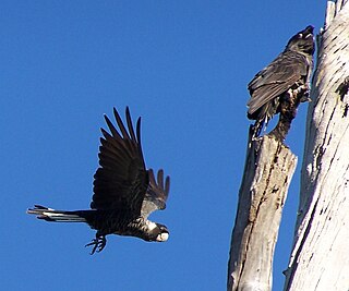
Baudin's black cockatoo, also known as Baudin's cockatoo or long-billed black cockatoo, is a species of genus Calyptorhynchus found in southwest Australia. The epithet commemorates the French explorer Nicolas Baudin. It has a short crest on the top of its head, and the plumage is mostly greyish black. It has prominent white cheek patches and a white tail band. The body feathers are edged with white giving a scalloped appearance. Adult males have a dark grey beak and pink eye-rings. Adult females have a bone coloured beak, grey eye-rings and ear patches that are paler than those of the males.

Calingiri Important Bird Area Important Bird Area in Western Australia

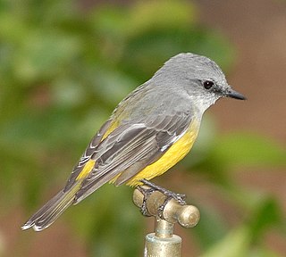
Calingiri Important Bird Area is an 807 km2 tract of land roughly centred on the town of Calingiri in the Wheatbelt region of Western Australia. It lies about 120 km north-east of Perth. It has been classified by BirdLife International as an Important Bird Area because it supports up to 20 breeding pairs of short-billed black cockatoo, an endangered species that nests in remnant patches of eucalypt woodland and isolated paddock trees, and feeds in native shrublands. The area also supports the restricted-range western corella and a globally important population of the western yellow robin.

Cataby Important Bird Area Important Bird Area in Western Australia

Cataby Important Bird Area is a 314 ha tract of land lying about 2 km south of the town of Cataby, adjacent to the Brand Highway, in the Wheatbelt region of Western Australia. It has been classified by BirdLife International as an Important Bird Area (IBA) because it supports up to 24 breeding pairs of short-billed black cockatoo, an endangered species that nests in remnant patches of eucalypt woodland and isolated paddock trees, and feeds in native shrublands. The area also supports the restricted-range western corella and a globally significant population of the regent parrot.

Gidgegannup Important Bird Area Important Bird Area in Western Australia

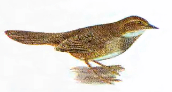
Gidgegannup Important Bird Area is a highly fragmented tract of land, where the fragments are patches. of remnant native vegetation, bounded by a circle roughly 12 km in diameter. It is in south-western Western Australia about 30 km north-east of Perth and on the dge of the Perth suburban region. The towns of Gidgegannup and Parkerville lie on the periphery. It has been identified by BirdLife International as an Important Bird Area (IBA) because it supports at least 450 Baudin's black-cockatoos, as well as small numbers of Carnaby's black-cockatoos, in roost sites outside the breeding season within foraging range of feeding habitat. The IBA also supports red-capped parrots, rufous treecreepers, western spinebills, western thornbills and western yellow robins.

Gillingarra Important Bird Area

Gillingarra Important Bird Area is an 83 km2 tract of land in the wheatbelt region of Western Australia. It is located near Mogumber and Koogan on the former Midland Railway line.

Jalbarragup Important Bird Area Important Bird Area in Western Australia

Jalbarragup Important Bird Area is a 258 km2, fragmented tract of land. It comprises the blocks of native vegetation of more than 1 ha on private land, water catchment areas, state forests, nature reserves and other reserves within a ten-kilometre radius of Jalbarragup in the shire of Nannup, south-west Western Australia. The area has a Mediterranean climate.

Koobabbie Important Bird Area

The Koobabbie Important Bird Area comprises several disjunct, mostly linear, patches of land with a collective area of 254 ha. It lies in the northern wheatbelt region of Western Australia, about 20 km south-east of Coorow. It consists of remnant salmon gum woodlands on the Koobabbie farming property that provide the nesting habitat of large tree hollows necessary for breeding cockatoos.

Moora Important Bird Area Important Bird Area in Western Australia

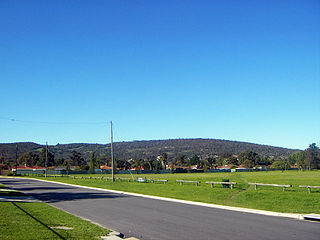
Moora Important Bird Area comprises a fragmented area of 685 ha centred on the rural township of Moora, in the wheatbelt region of south-west Western Australia. It lies about 175 km north of Perth. Most of the site is private land.

Natimuk-Douglas Wetlands

The Natimuk-Douglas Wetlands comprise a chain of freshwater, brackish and saline wetlands in the semi-arid Wimmera region of western Victoria. Australia. They are important for waterbirds.

North Dandalup Important Bird Area Important Bird Area in Western Australia

North Dandalup Important Bird Area comprises a highly fragmented 76 km2 tract of land lying about 50 km south of Perth in the Peel region of south-west Western Australia. It is named after the nearby small town of North Dandalup.

Northern Swan Coastal Plain Important Bird Area Important Bird Area in Western Australia

The Northern Swan Coastal Plain Important Bird Area comprises a 2307 km2 tract of land in south-west Western Australia.

The Lakes Important Bird Area Important Bird Area in Western Australia

The Lakes Important Bird Area comprises some 72 km2 of land near the community of The Lakes in the Shire of Mundaring on the eastern fringe of the metropolitan area of Perth, Western Australia. It is an important site for the conservation of threatened Western Australian black cockatoos.

Two Peoples Bay and Mount Manypeaks Important Bird Area Important Bird Area in Western Australia

The Two Peoples Bay and Mount Manypeaks Important Bird Area is a 261 km2 tract of coastal and subcoastal land east of the city of Albany in south-west Western Australia. It is an important site for the conservation of several rare and threatened birds.

Walebing Important Bird Area Important Bird Area in Western Australia

The Walebing Important Bird Area comprises a 13 km2 tract of land in the vicinity of the rural township of Walebing, in the northern whatbelt region of south-west Western Australia.

Araluen-Wungong Important Bird Area

The Araluen-Wungong Important Bird Area is a 123 km2 tract of land in the Darling Ranges on the south-eastern fringe of the city of Perth, Western Australia. The name derives from the Araluen Botanic Park within the Important Bird Area (IBA) and the adjacent suburb of Wungong. It is an important site for black cockatoos.

Bindoon-Julimar Important Bird Area Important Bird Area in Western Australia

The Bindoon-Julimar Important Bird Area is a fragmented 525 km2 tract of land in the northern Darling Ranges, of south-western Western Australia. It is about 5 km east of the town of Bindoon and 80 km north of Perth, on the edge of the wheatbelt. It lies between the Calingiri and Northern Swan Coastal Plain IBAs.

References

  1. 1 2 BirdLife International. (2011). Important Bird Areas factsheet: Mundaring-Kalamunda. Downloaded from http://www.birdlife.org on 23/08/2011.
  2. "IBA: Mundaring-Kalamunda". Birdata. Birds Australia. Retrieved 2011-08-23.

Coordinates: 31°57′38″S116°08′23″E / 31.96056°S 116.13972°E / -31.96056; 116.13972

Geographic coordinate system Coordinate system

A geographic coordinate system is a coordinate system that enables every location on Earth to be specified by a set of numbers, letters or symbols. The coordinates are often chosen such that one of the numbers represents a vertical position and two or three of the numbers represent a horizontal position; alternatively, a geographic position may be expressed in a combined three-dimensional Cartesian vector. A common choice of coordinates is latitude, longitude and elevation. To specify a location on a plane requires a map projection.