
Kanjirappally is a taluk and a town in Kottayam district situated about 38 km (24 mi) away from the district capital, in the state of Kerala, India.
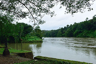
Mundakayam, is a town in Kanjirappally Taluk in the Kottayam District of Kerala. It is the doorway to the high ranges of southern Kerala, and is at the border of Kottayam and Idukki districts. The next nearest town, Kanjirappally, is 14 km (8.7 mi) & Erumely is 12 km from Mundakayam. Mundakayam has rubber plantations, and greenery. The Manimala River runs through Mundakayam. It is located 48 km east of the district headquarters at Kottayam and 148 km from the state capital, Thiruvananthapuram. The name Mundakayam is said to be derived from the Mundi cranes that used to be seen along the Manimala River banks.
Ayroor is a village located in the western part of Ranni taluk, in the Pathanamthitta district in Kerala state, India. It is bordered by hills and located near the Western Ghats. Ayroor was previously part of Thiruvalla taluk in Alleppey district and is considered part of the Edanadu region in Kerala. The Pamba River flows on the southern side of the village.

Ranni or Ranny is a town in the Pathanamthitta district of Kerala, India, and the 16th largest taluk in Kerala, located on both sides of the Pamba River.It Is Located 30 km From Thiruvalla Railway Station & NH 183 in Thiruvalla.Buses Ply Every 5 minutes From Thiruvalla To Ranni & Vice Versa

Pathanamthitta, is a municipality situated in the Central Travancore region in the state of Kerala, India, spread over an area of 23.50 km2. It is the administrative capital of Pathanamthitta district. The town has a population of 37,538. The Hindu pilgrim centre Sabarimala is situated in the Pathanamthitta district; as the main transport hub to Sabarimala, the town is known as the 'Pilgrim Capital of Kerala'. Pathanamthitta District, the thirteenth revenue district of the State of Kerala, was formed with effect from 1 November 1982, with headquarters at Pathanamthitta. Forest covers more than half of the total area of the District. Pathanamthitta District ranks the 7th in area in the State. The district has its borders with Allepey, Kottayam, Kollam and Idukki districts of Kerala and Tamil Nadu.Nearest City Is Thiruvalla,Located At A Distance Of 30 km .Thiruvalla Railway Station Is 30 km via Thiruvalla-Kumbazha Highway.Buses Ply Every 4 Minutes From Thiruvalla To Pathanamthitta & Vice Versa.

Nedumkunnam is a village in Kerala, India, located about 16 km East of Changanacherry on Changanacherry-Manimala Road, in Kottayam district. It is 3 km East of Karukachal towards Manimala/Cheruvally.

Kangazha is a panchayath and village in the Changanacherry Taluk of the Kottayam District of Kerala State in India. It is located 21 kilometers east of Kottayam and 10 kilometers north of Karukachal. It lies midway between the backwaters of Western Kerala and the misty mountains of the Western Ghats.

Punnavely is a village situated on the border of Pathanamthitta and Kottayam districts of Kerala, India. Punnavely is a typical Central Tranvancore village with rubber tree plantations, paddy fields, pepper and other spices and lot of NRIs.
Manimala is a small town and a village in Kottayam district in the Indian state of Kerala, situated about 12 kilometres (7.5 mi) from the nearest town Kanjirappally. It's declared as a folklore village since 2011 by the central government to promote folklore.
Nedungadappally is a village in between Mallappally and Karukachal in Kerala, India. It is near the boundary of Kottayam and Pathanamthitta districts. Nedungadappally is known for churches and schools. It's a quiet and scenic place with all necessary amenities such as grocery shops, stationery shops, hotels, banks, bakery shops etc. Nedungadappally is a junction of 4 roads heading towards Kottayam, Mallappally, Changanasserry and Thiruvalla.
Perunad (Ranni-Perunad) is a scenic hilly village in Pathanamthitta district, Kerala state, India.Nearest Railway Station Is Thiruvalla Located At A Distance Of 62 km. It's located on the banks of Pamba River and Kakkadu River.

Chemperi is a town on the bank of the Chemperi River, in the Western Ghat, in the Kannur district of South India. Chemperi is often referred as the education city of Kannur with the establishment of Vimal Jyothi Engineering College, Chemperi. It is characterized by its production and export of rubber and spices, its beautiful hillocks, and its serene streams. Village and Panchayath of Chemperi is Eruvessi. Both Panchayath and Village offices of Eruvessi are located in Chemperi. Also Lourde Matha Forane Church, Chemperi is another attraction.Paithalmala and Palakkayam thatt is also a few kilometres away from here.
Njeezhoor is a village in Kottayam district in the state of Kerala, India. Njeezhoor is also spelled Neezhoor. Njeezhoor is situated at the northern end of Kottayam (30 km).Distance to Cochin is only 45 km. The nearest railhead is piravom road Railway Station (12 km). Even though it’s a remote village in Kerala, the population has 98% Literacy, Good Educational institutions, cellular phone coverage, Telephone exchange, internet facilities, good transportation systems, irrigation systems etc. Njeezhoor grama panchyat has been awarded two time "The best panchyat in Kottayam district".

Ezhumattoor is a village in Pathanamthitta district in the state of Kerala, India,since the formation of Pathanamthitta district in 1982. Ezhumattoor has 27.89 km2 area,it is divided into 14 wards for administrative purpose,it was formed by a government Order on 16 January 1952.
Mammood is a small village in Kottayam district of Kerala state in India. Mammood falls under Madapally Panchayat and Chanaganacherry Thaluk. The village is situated about 10 km away from Changanacherry town. Changanacherry-Vazhoor Road passes through this village. Around 20,000 people lives here. The greenish landscape includes rubber plantations, paddy fields, coconut trees, pepper, mango trees, coca, and a wide variety of plants and trees.
Keezhvaipur is a village in the Mallappally Taluk which is one of five Taluks that makes up the Pathanamthitta district, in Kerala State, India. Keezhuvaipur lies in the bank of river Manimala and is famous for its traditions, cultures, and customs. The town is located on the Kottayam-Punalur State Highway. Keezhuvaipur is 3 km away from Mallappally, 11 km from Kozhencherry and 13 km from Tiruvalla.
Thiruvarambu is one among the town of Thiruvattar town panchyat. The Thirparappu Falls is 3 km from Thiruvarambu. This having a canal like stream originated from some of the dams which provides more enough water to this village. Hence they plant banyan, coconut, banana, rubber, tapioca and other pulses such as pepper.

Angamoozhy is a village in Pathanamthitta district in the Indian state of Kerala. Angamoozhy is located near the Kakkad power station and the Sabarimala temple. Geographically Angamoozhy is High-range area.

Muttom is a rural area in Idukki district in the Indian state of Kerala. This place is 66 km away from Cochin. Geographically this place is part of Midland or Idanad region of Kerala. Hindus, Christians and Muslims are living peacefully in the area.

Kottanad is a village in Pathanamthitta district in the state of Kerala, India.

