
The City of Nedlands is a local government area in the inner western suburbs of the Western Australian capital city of Perth, about 7 kilometres (4 mi) west of Perth's central business district. The city is situated within the western suburbs of the metropolitan area—known colloquially as the “golden triangle” for the concentration of wealth and high housing values.

The City of Bayswater is a local government area in the Western Australian capital city of Perth, about 7 kilometres (4 mi) northeast of Perth's central business district. The city covers an area of 34.6 square kilometres (13.4 sq mi) and had a population of 69,283 as at the 2021 Census. The City of Bayswater is a member of the Eastern Metropolitan Regional Council.

The Town of Cambridge is a local government area in the inner western suburbs of the Western Australian capital city of Perth, about 5 kilometres (3 mi) west of Perth's central business district and extending to the Indian Ocean at City Beach. The Town covers an area of 22.0 square kilometres (8.5 sq mi) and had a population of almost 29,000 as of the 2021 Census. It was originally part of the City of Perth before the restructuring by the Western Australian State Government in 1994.

The Town of East Fremantle is a local government area in the southern suburbs of the Western Australian capital city of Perth, located immediately northeast of the port city of Fremantle and about 17 kilometres (11 mi) southwest of Perth's central business district. The Town covers an area of 3.1 square kilometres (1.2 sq mi), maintains 46 km of roads and had a population of over 7,000 as at the 2016 Census.

The Town of Mosman Park is a local government area of Western Australia. It covers an area of approximately 4.3 km2 in western metropolitan Perth, the capital of Western Australia and lies about 14 km southwest of the Perth CBD and 5 km from Fremantle.
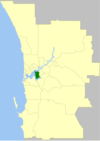
The City of South Perth is a local government area in the inner southern suburbs of the Western Australian capital city of Perth about 4 kilometres (2.5 mi) south of Perth's central business district. The City covers an area of 19.9 square kilometres (7.7 sq mi), maintains 203 kilometres (126 mi) of roads and a little over 4.3 km2 of parks and gardens, and had a population of about 42,000 at the 2016 Census. The City is the entirety of the state electoral district of South Perth. An area of Kensington joined into South Perth after the 2013 redistribution, although dwindling population growth in Victoria Park may mean that part of the City will move back.

Subiaco is an inner-western suburb of Perth, the capital of Western Australia. It is approximately 3 km (1.9 mi) west of Perth's central business district, in the City of Subiaco local government area. Historically a working-class suburb containing a mixture of industrial and commercial land uses, since the 1990s the area has been one of Australia's most celebrated urban redevelopment projects. It remains a predominantly low-rise, urban village neighbourhood centred around Subiaco train station and Rokeby Road.

The City of Vincent is a local government area of Western Australia. It covers an area of approximately 10.4 square kilometres (4.0 sq mi) in metropolitan Perth, the capital of Western Australia, and lies about 3 km from the Perth CBD. The City of Vincent maintains 139 km of roads and 104 ha of parks and gardens. It had a population of over 33,000 at the 2016 Census.
The Electoral district of Leederville was a Legislative Assembly electorate in the state of Western Australia. The district was named for the inner northern Perth suburb of Leederville, which fell within its borders. Starting off as a vast seat covering most of Perth's northwestern hinterland, it shrank in size at various redistributions until, by the time of its abolishment, it was an inner suburban seat able to be absorbed into Wembley and Mount Hawthorn.

West Leederville is a suburb 3 kilometres (1.9 mi) northwest of the central business district of Perth, the capital of Western Australia, and is within the Town of Cambridge. It used to be integrated with Leederville prior to the construction of the Mitchell Freeway through the suburb in 1972.

The City of Perth is a local government area and body, within the Perth metropolitan area, which is the capital of Western Australia. The local government is commonly known as Perth City Council. The City covers the Perth city centre and surrounding suburbs. The City covers an area of 20.01 square kilometres (8 sq mi) and had an estimated population of 21,092 as at 30 June 2015. On 1 July 2016 the City expanded, absorbing 1,247 residents from the City of Subiaco.

Leederville Oval is an Australian rules football ground located in Leederville, a suburb of Perth, Western Australia. The ground is used as a home ground by two clubs: the East Perth Football Club and the Subiaco Football Club, both competing in the West Australian Football League (WAFL). The ground was previously home to the West Perth Football Club from 1915 to 1993, before the club moved to Arena Joondalup, its current home ground. The ground is serviced by the Yanchep line, with the nearest stop being Leederville station.

The Town of Claremont is a local government area in the inner western suburbs of the Western Australian capital city of Perth, located about halfway between the port city of Fremantle and Perth's central business district. The Town covers an area of 4.9 square kilometres (1.9 sq mi), maintains 48 km of roads and 87 km of footpaths, and has a population of approximately 10,000 as at the 2016 Census.

The Town of Cottesloe is a local government area in the western suburbs of Perth, the capital of Western Australia. It covers the suburb of the same name as well as a tiny portion of the suburb of Claremont. Cottesloe is located 11 kilometres (7 mi) west of Perth's central business district, covers an area of 3.9 square kilometres (1.5 sq mi), maintains 45.7 km of roads and had a population of approximately 7,500 as at the 2016 Census. Cottesloe is served by Swanbourne, Victoria Street, Grant Street and Cottesloe train stations, all operated through the Fremantle Railway Line. Various bus routes operate along Stirling Highway, enabling transport through the suburb's western and eastern precincts with Perth and Fremantle. All services are operated by the Public Transport Authority. The Town of Cottesloe's inclusion of walk and cycle paths enable it to be a walkable precinct.

The City of Subiaco is a local government area in Western Australia. It covers an area of approximately 7 km² in inner western metropolitan Perth and lies about 3 km west of the Perth CBD. The City includes the historically working-class suburb of Subiaco centred around Rokeby Road. Since the 1990s the area has been extensively redeveloped and gentrified.

Central Institute of Technology was a Technical and Further Education (TAFE) institution based in Perth, Western Australia until 2016, at which point it became a part of North Metropolitan TAFE. It was the equal oldest post-secondary educational institution in Western Australia and the largest TAFE institution in Perth.

Luna Leederville is a cinema complex located at the corner of Oxford and Vincent streets in Leederville, a suburb of Perth, Western Australia.

The Municipality of North Perth was a local government area in inner suburban Perth, Western Australia, centred on the suburb of North Perth.
The Municipality of Victoria Park was a local government area in the inner eastern suburbs of Perth, Western Australia.
