
The Town of Cambridge is a local government area in the inner western suburbs of the Western Australian capital city of Perth, about 5 kilometres (3 mi) west of Perth's central business district and extending to the Indian Ocean at City Beach. The Town covers an area of 22.0 square kilometres (8.5 sq mi) and had a population of almost 29,000 as of the 2021 Census. It was originally part of the City of Perth before the restructuring by the Western Australian State Government in 1994.

The Town of Victoria Park is a local government area of Western Australia. It covers an area of 17.62 km² in metropolitan Perth, the capital of Western Australia. It had a population of approximately 35,000 as at the 2016 census.

The City of Vincent is a local government area of Western Australia. It covers an area of approximately 10.4 square kilometres (4.0 sq mi) in metropolitan Perth, the capital of Western Australia, and lies about 3 km from the Perth CBD. The City of Vincent maintains 139 km of roads and 104 ha of parks and gardens. It had a population of over 33,000 at the 2016 Census.

The City of Perth is a local government area and body, within the Perth metropolitan area, which is the capital of Western Australia. The local government is commonly known as Perth City Council. The City covers the Perth city centre and surrounding suburbs. The City covers an area of 20.01 square kilometres (8 sq mi) and had an estimated population of 21,092 as at 30 June 2015. On 1 July 2016 the City expanded, absorbing 1,247 residents from the City of Subiaco.

A coffee palace was an often large and elaborate residential hotel that did not serve alcohol, most of which were built in Australia in the late 19th century.

Leederville Oval is an Australian rules football ground located in Leederville, a suburb of Perth, Western Australia. The ground is used as a home ground by two clubs: the East Perth Football Club and the Subiaco Football Club, both competing in the West Australian Football League (WAFL). The ground was previously home to the West Perth Football Club from 1915 to 1993, before the club moved to Arena Joondalup, its current home ground. The ground is serviced by the Yanchep line, with the nearest stop being Leederville station.
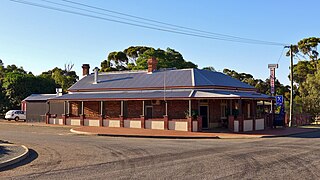
Highbury, originally Wolwolling, is a small town in the Wheatbelt region of Western Australia, located along the Great Southern Highway between Narrogin and Wagin. At the 2006 census, Highbury had a population of 493.

The Shire of Beverley is a local government area in the Wheatbelt region of Western Australia about 130 kilometres (80 mi) southeast of Perth, the state capital. The Shire covers an area of 2,372 square kilometres (916 sq mi), starting 20 kilometres (12 mi) outside Armadale in the Darling Scarp and extending eastwards beyond the scarp into agricultural lands which support broad acre activities such as livestock and cropping. Its seat of government is the town of Beverley, which accommodates just over half of the Shire's population.

The City of Subiaco is a local government area in Western Australia. It covers an area of approximately 7 km² in inner western metropolitan Perth and lies about 3 km west of the Perth CBD. The City includes the historically working-class suburb of Subiaco centred around Rokeby Road. Since the 1990s the area has been extensively redeveloped and gentrified.

The City of Fremantle is a local government area in the south of Perth, Western Australia. The City covers an area of 19.0 square kilometres (7.3 sq mi), and lies about 19 kilometres (12 mi) southwest of the Perth central business district.
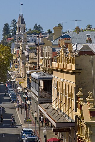
High Street is the main street running through the City of Fremantle, Western Australia. The street passes by historic landmarks, including the Round House, the Fremantle Town Hall, and the Fremantle War Memorial, through the Fremantle West End Heritage area and through two town squares. Trams operated along High Street for 47 years, between 1905 and 1952. Running east–west, High Street continues as Leach Highway, a major arterial road, at Stirling Highway, linking Fremantle with Perth Airport although the stretch of road between Stirling Highway and Carrington Street is known locally—and signed—as High Street.
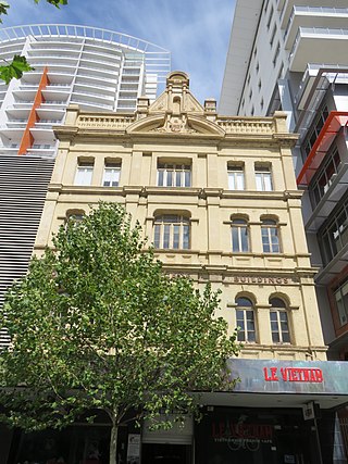
Bon Marché Arcade, also known as Bon Marché Buildings, is a heritage-listed building in Perth, Western Australia], located at 74–84 Barrack Street in the Perth central business district. It is three and four storeys tall, built in 1901 from brick in the Federation Free Classical architectural style, with a tin roof. Designed by architect H. J. Prockter, it was a prominent feature in Barrack Street when constructed, being taller than the one or two story buildings surrounding it.
The Town of Carnarvon was a local government area in Western Australia.

The Municipality of Leederville was a local government area in inner suburban Perth, Western Australia, based around the suburb of Leederville.
The Municipality of Victoria Park was a local government area in the inner eastern suburbs of Perth, Western Australia.
The Municipality of Cue was a local government area in Western Australia centred on town of Cue.
The Municipality of Beverley was a local government area in Western Australia centred on the town of Beverley, in the Wheatbelt region of Western Australia
The Municipality of Broome was a local government area in Western Australia centred on the coastal town of Broome. It existed from 1904 to 1918.
