Munjenahalli

Last updated

Munjenahalli
Manjenahalli
Village
Chagachagere (1).jpg
Munjenahalli
CountryFlag of India.svg  India
State Karnataka
District Hassan
Taluk Arasikere
Population
 (2011)
  Total487
Languages
  Official Kannada
Time zone UTC+5:30 (IST)
Pin code
573164
Telephone code 08172
Vehicle registration KA-13

Munjenahalli (Manjenahalli) is a small village in Arsikere taluk, Hassan district, in the Indian state of Karnataka. The village has population of 487 of which 238 are males and 249 are females as per Population Census 2011. [1]

Contents

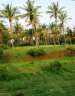
It is located 24 kilometers from Arsikere (taluk headquarters) and 32 kilometers from its district headquarters Hassan. Agriculture is the major occupation of the village, grows majorly Coconut, also variety of crops like Finger millet, Jawar, Tomato, Potato etc.

Governing body

Manjenahalli is under the Grama Panchayat Chagachagere which is 2 kilometers from the village.

Culture

Lakshmidevi and Chamundeshwari temple is the largest temple, also a village goddess and has huge number of devotees outside the village, apparently a crowded fair dedicated to Chamundeshwari takes place in the time of March Holi. Hanuman-anjuneya, Shiva- sree someshwara , sree Lakshmi devi, Mutturayaswamy and Plegalamma are also worshiped by people in the village notably. People of Manjenahalli believed that Devi Chamundeshwari is powerful goddess, on every pournami Amavasya evening a special worship takes place, where devotees from different places gather and get resolved their problems.

Transportation

Nearest Bus station is Gandasi hand post from where direct buses are available to Hassan, Arasikere, Channarayapattana and Tiptur. Nearest railway station is Arasikere where trains are available to Bangalore, Mysore, Mumbai, Hyderabad & more key destinations.

See also

Related Research Articles

<span class="mw-page-title-main">Meenachil</span> Taluk in Kerala, India

Meenachil is the north-eastern region of Kottayam district in Kerala, south India. The name originates from Meenakshi, the Hindu Goddess. Pala is the main city in Meenachil. The arterial river of the district is also named Meenachil.

<span class="mw-page-title-main">Arsikere</span> City in Karnataka, India

Arsikere is a city and taluka in the Hassan district in the state of Karnataka, India. It is the second largest city in Hassan district, demographically. Arsikere city municipal council consists of 35 wards. This region is known for its coconut production and is also called Kalpataru Nadu. Arsikere Junction is a major railway junction in the South Western Railway which links Mangalore and Mysore to North Karnataka and a central place for tourists who visit nearby places that do not have rail access, such as Belur, Halebidu and Shravanabelagola, Harnahalli, and Kodimata.

<span class="mw-page-title-main">Hassan district</span> District of Karnataka in India

Hassan is one of the 31 districts of Karnataka, India. The district headquarter is Hassan. It was carved out from Mysore district in the year 1866, during the Commissioner's Rule of Mysore (1831-81).

<span class="mw-page-title-main">Pattazhy</span> Village settlement Pattazhy in Kerala, India

Pattazhy, also Pattazhi is a village located in Pathanapuram taluk in the eastern part of the Kollam District, Kerala state, India. It is best known as the site of an ancient Bhagavathy temple, Pattazhy Devi Temple.

Karuvatta is a village in Alappuzha District of Kerala region of India. It lies in between Haripad and Thottappally in Alappuzha, on National Highway 66. Karuvatta has a railway station, and the nearest airports are Trivandrum International Airport and Cochin International Airport.

Karunagappally is a municipality in the Kollam district of Kerala, India. It is 24 km north of Kollam and 60 km (37 mi) south of Alappuzha. Karunagappally taluk consists of Alappad, Ochira, Adinad, Karunagappally, Thazhava, Pavumba, Thodiyoor, Kallalibhagom, Thevalakkara, Chavara, Neendakara, Clappana, Kulasekharapuram, Thekkumbhagam, Ayanivelikulangara, Panmana, Ponmana and Vadakumthala. The taluk is bound on the north by Kayamkulam, on the east by Kunnathur taluk, on the south by Kollam and on the west by the Arabian Sea. It is one of the fastest developing towns in Kerala and is part of Kollam metropolitan area.

Padur (or Padoor) is a village in Palakkad District, Kerala. There is a temple of Sree Panickanar where a yearly festival called Padur Vela is celebrated, which is well attended for Vela-Poorams in Palakkad.

<span class="mw-page-title-main">Chirakkara</span> Village in Kerala, India

Chirakkara is a village in Kollam district in the state of Kerala, India. Chirakkara is 16 km away from the town of Kollam and 8 km away from Paravur Town, which is famous for festivals, estuary, backwaters and beaches.

<span class="mw-page-title-main">Sasthamkotta</span> Village in Kerala, India

Sasthamkotta or Sasthamcotta is a village in the Kunnathoor Tehsil of Kollam district in the state of Kerala, India. Kunnathoor taluk headquarters is located at Sasthamkotta. The Sasthamkotta freshwater lake is the largest freshwater lake in Kerala.

Karakulam is a panchayat in Nedumangad Taluk in Tiruvananthapuram District in the state of Kerala, India. It is the most populated panchayat in the district according to 2011 census.

Vellarada is a border village situated in Thiruvananthapuram district in the state of Kerala, India. It is 42 km from Thiruvananthapuram. It is the southernmost part of Kerala state, sharing its border with Tamil Nadu. Vellarada is said to be the threshold to the high-range areas of the eastern part of Thiruvananthapuram district. The southernmost point of Western Ghats in Kerala is near Vellarada.

<span class="mw-page-title-main">Mangasuli</span> Village in Karnataka, India

Mangasuli is a village located in Northern Karnataka, India. It is located in the Athani taluk of Belgaum district in Karnataka.

<span class="mw-page-title-main">Morkulangara Devi Temple</span> Hindu temple

Morkulangara Devi Temple is a famous Hindu temple in the Kottayam District of Kerala state in India. The presiding deity is Bhagavathy. The prime feature of this temple is the deity having a height of more than 6 feet. It is believed that the Devi in Morkulangara temple placed in this place after killing the demon Darika.

Velur or Veloor is a village and panchayat in Kunnamkulam Taluk, Thrissur district, Kerala, India with a population of 22,155. Other places close to Velur are Kechery, Wadakkanchery etc.

Adichikkavu Sree Durga Devi Kshetram, also known as the Adichikavu (Adichicavu) Devi Temple is one of the oldest temple in Pandanad village, Alapuzha. The temple is located at Pandanad in Chengannur taluk of Alappuzha district in the south Indian state of Kerala. The temple is situated about 6 km west of Chengannur, and 4 km east of Mannar.

<span class="mw-page-title-main">Karagaon</span> Village in Karnataka, India

Karagaon is a village in Belgaum district in the south western state of Karnataka, village located 16 kilometers from Chikodi and 64 kilometers from its district headquarters Belgaum. Agriculture is the major occupation of the village, grows variety of corps like sugar cane, jawar, soybean, tobacco, and peanuts.

<span class="mw-page-title-main">Saligrama, Mysore</span> Town in Karnataka, India

Saligrama is a new sub-district of Mysore district, situated on the northern bank of the river Cauvery [Kaveri]. This place is esteemed as sacred by the Shri Vaishnavas on account of its having been the residence of Sri Ramanujacharya. It is the headquarters of Saligrama Taluk. It was established as a new taluk carving out of K.R.Nagar taluk with effect from 31.12.2020 and become ninth taluk of Mysore district of Karnataka, India.

Adikadalayi is a village situated 6 kilometers from Kannur town in Kannur district. It is a tourist area located near the village of Edakkad. It is in this village that the famous Kadalayi Sree Krishna Temple is situated. The temple attracts thousands of devotees from far and near. Adikadalayi Sri Krishna Temple is located in the heart of Adikadalayi.

Lachyan is a village situated in the Indi Taluka of Bijapur district, Karnataka, India. As of the Population Census 2011, Lachyan is home to 4,586 people distributed across 865 families.

Gandasi is a "hobli" in Hassan district of India. As per census survey of India 2011, the location code number of Gandasi is 615799.

References