Arasikere is a city and taluka in the Hassan district in the state of Karnataka, India. Arsikere also called as Siddara Nadu. It is the second largest city in Hassan district, demographically. Arsikere city municipal council consists of 35 wards. This region is known for its coconut production and is also called Kalpataru Nadu. Arsikere Junction is a major railway junction in the South Western Railway which links Mangalore , Bangalore and Mysore to North Karnataka and a central place for tourists who visit nearby places that do not have rail access, such as Belur, Halebidu and Shravanabelagola, Harnahalli, and Kodimata.
The name Arasikere originates from one of the princesses of the Hoysala dynasty, who built a lake (kere in Kannada) near the town. Arasi means queen in Kannada. Therefore, it is 'Arasiya+kere' which means "queen's pond".[2] Arasikere was also called Udbhava Sarvagna Vijaya and Ballālapura at various times.
Under the rulers of Vijayanagara, it was under the administrative control of Jagadevaraya of Channaptna and later placed under Thimmappa Nayaka of Tarikere. It was finally under the rule of Shivappa Nayaka of Ikkeri and was acquired from Ikkeri rulers by the Mysore Wodeyars in 1690.
Under the rule of the Wodeyars of Mysore, the area suffered from the raids of the Marathas, and was subsequently turned over to the Marathas by the Wodeyars as security for the payment of tribute.
Towards northeast of the city, there is a mountainous scrub forest, known as the Nagapuri Forest. Old temples are found in isolation. Bears and Leopards population is the highlight of this forest. The elevation of the forest lies between 900 metres (3,000ft) to 1,240 metres (4,070ft) above mean sea level.[4]
Climate
The winter temperature averages between 14°C (57°F) and 26°C (79°F). Summer temperature average between 19°C (66°F) and 35°C (95°F).[5]
Education
Notable educational facilities in Arsikere include the following:
School's and colleges
Sharadha English school
St Mary's High school
Sri Adichunchanagiri English School, Higher primary school, Arsikere
St marys school (Kannada medium)
Niveditha English Higher primary school
Ananth International school
St Mary's English Higher primary school
Aashirvad Public school
Govt Girls High School
Sri Basvarajendra High School
Sri Gouramma School
Sri Vasavi School
Sri Vidyashankara Public School
Anubhava Mantapa (S.T.J)
Rotary school
Basaveshwara higher primary school
Sri Vidya Shankara Public School
Podar International School
Colleges
JSKPU College
Jnanashree expert pu college
KPS pu college, arsikere
Ananth PU College
Adhichunchanagiri Science PU college
Siddeshwara pu college
Prathiba College
Vivekananda College of Education
Government Boys Junior College
Hoysaleshwara pu college
Ananthasadvidya College of Education
Al Ameen College
Hoysaleshwara degree College
Vivekananda BEd College
Govt first grade college Arasikere
Royal institute Of Commerce(Royal Degree College)
Government Engineering College, Arsikere
Government polytechnic college, Arsikere
Transportation
Arsikere serves as a common point for people travelling from Bengaluru to Northwest Karnataka and for commuters from Mysuru towards all of Northern Karnataka. Thus, public transport buses of 3 branches of KSRTC can be found here. KSRTC also has a bus depot in Arasikere, operated under Chikkamagaluru division. Tumakuru-Shivamogga four-lane expressway, comprising parts of NH-73 (Tumkur-Banavar) & NH-69 (Banavar-Shivamogga) is under construction, as of Nov-2022.Arsikere-Mysore national highway and Arsikere-Hassan highway.[6]
Nearly 120+ trains stop here and is around 166km from state capital Bengaluru. It has five trains starts from here to Bengaluru, Mysuru, Shivamogga and Hubballi. Around 30,000 people travel from Arsikere to other parts of Karnataka every day.
Various festivals are celebrated in Arasikere, including the following:
Yadhapura "Sri Jenukallu Siddeshwara Swamy Jatramahotsava" is a big festival held every month during full moon day.
GanapathiPendal (where a large Ganesha statue is displayed for about ninety days in Pendal), Ganapathi Chathurti, and Ganapathi Visarjana which has been celebrated from past 72(in 2017) years (where an idol of Ganesha is immersed into the lake near Arasikere). During these festivals, Sports, cultural, and spiritual activities are organized.
Madalu "Sri Swarna Gowri JathraMahotsava" is the biggest festival in Arasikere Taluk which is held during Gowri - Ganesha festival.
Undiganalu "Sri Kariyamma Devi Jatramahotsava" is the biggest festival in Arasikere taluk which is held in the month of April.
Malekallu Thirupathi Fair takes place annually for the god Venkataramana and Govindaraja.
Places of interest
Notable places around Arsikere include the following:
Temples and architecture
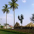
The Kalameshwara Temple (also Ishwara), also known as Kattameshvara and Chandramoulishvara by devotees, is a monument in the Hoysala style of architecture. It faces east and dates to 1220 A.D.
Sahasrakuta Jinalaya has a Hoysala building from 1220 A.D. and was constructed by Vasudhaika bandhava Recharasa, a minister of Veera Ballala II.
Malekal Tirupathi Hill, also called (Chikka Tirupati) is three kilometers from Arsikere and has two temples: (Venkataramana and Govindaraja), which are frequently visited by pilgrims. Malekal Tirupathi Hill has 1,300 steps and a standing Venkateshwara idol.[2]
Chikka Tirupati which is also called as Malekallu Tirupati or Amaragiri Malekallu Tirupati. It is located 3km away from Arsikere, Hassan district. The main God worshipped here is Lord Balaji or Sri Venkataramana Swamy. There is a temple on the top of the hill which contains 1300 steps. There is a belief that sage Agasthya had offered prayers here to Lord Balaji and was blessed with lords Darshan here. It is also said that the sage Vashista lived here and went to atonement by worshipping Lord Venkataramana Swamy, and on the day of Suddha Dwadashi Lord appeared and blessed him and hence this day every year a Maharathothsava will be held and is celebrated as one of the biggest festivals.
Jenukallu Siddeshwara swamy hill Jenukallu siddeshwara Betta (hill)
Arasikere is home to naturally built elephant stone, situated at heart of the town in Shri Subrahmanya Ane Betta.
Sri Siddarameshwara Gadduge is located 12 kilometers from Arsikere, near Banavara.
Sri Devamma Devi Devalaya T Kodihalli near Thalalur is located 10 kilometers from Arsikere city.
Sri Veerabhadra Swami and Honaldajji Temple of Jajur is located 2 kilometers from Arsikere center.
Shree shyla Mallikarjuna temple, Challapura is located 8 kilometers from trekking*
Others
The Nagapuri fortress, built on the Hirekal hill, is eleven kilometres north of Arasikere and is said to have been constructed by Hyder Ali.
Nearby towns and places of interest
Madalu Sri Swarna Gowri (also called as Madalu Gowramma) is a popular festival celebrated in a nearby town called Madalu. This is celebrated during Gowri - the Ganesha festival.
Undiganalu which is the village located in between Arasikere and Javagal there are historical temples called Kariyamma Devi Temple, Chamundeshwari Temple, Gavisiddeshwara temple (located in the hill top), Bhalu Basaveshwara Temple (located midway). There are many festivals in that the Kariyamma Devi Jathramahothsava is one of the popular festivals in Arasikere Taluk. Unidiganalu is located 28km from Arasikere and 11km from Javagal.
Javagal, the hobli, is about 33km from Arasikere and about 35km from Hassan. It has a temple dedicated to Lakshminarasimha, which is a well preserved specimen of Hoysala architecture with an outer entrance. The temple is attributed to the middle of the 13th century A.D.[7]
Haranahally is a large village about eight kilometres south of Arasikere; there are remains of an old fort that is said to have been erected in 1070 A.D. by a chief named Someshvara Raya. There is a large Nagarti tank, which was named after his daughter.
Bannavara is a nearby town where one can see an old forts and a temple.
This page is based on this Wikipedia article Text is available under the CC BY-SA 4.0 license; additional terms may apply. Images, videos and audio are available under their respective licenses.