
Perkiomen Township is a township in Montgomery County, Pennsylvania, United States. As of the 2010 census, the township population was 9,139, which represents a 28.8% increase from the 2000 total of 7,093 residents. Governmentally, it is a township of the second class, governed by a board of supervisors. It is part of the Perkiomen Valley School District. Perkiomen Township includes an abundance of history that goes as far back as to the first tribes who inhabited the area. This township started with the inhabitants of the Lenni-Lenape Tribe and progressed in many ways into what it is today.

The Matobo National Park forms the core of the Matobo or Matopos Hills, an area of granite kopjes and wooded valleys commencing some 35 kilometres (22 mi) south of Bulawayo, southern Zimbabwe. The hills were formed over 2 billion years ago with granite being forced to the surface; it has eroded to produce smooth "whaleback dwalas" and broken kopjes, strewn with boulders and interspersed with thickets of vegetation. Matopo/Matob was named by the Lozwi, who are the ancestors of Kalanga. A different tradition states that the first King, Mzilikazi Khumalo when told by the local residents that the great granite domes were called madombo he replied, possible half jest, "We will call them matobo" - an IsiNdebele play on 'Bald heads'.
Mukarakate is a place in the north-eastern Murewa district of Zimbabwe. The district is in Mashonaland East province of Zimbabwe. It is almost entirely inhabited by Shona-speaking people. The traditional rulers of the area are the Nhowe people, whose chieftainship is called Mangwende. Many of the Nhowe people use Mukarakate as a surname, because it is the name of a great-great-ancestor of the tribe. Their totem is 'Moyo Muzukuru', which uses the bull as its symbolic animal. However, in practice, the tribe strictly holds only the heart of the animal as sacred, not the whole animal. Currently, the Mangwende Chieftainship is vacant following the death of Jonathan Tafirenyika Chibanda who passed on in South Africa on 16 December 2013. Chief Jonathan Mangwende was once president of the chief's council. Jonathan Tafirenyika Chibanda was the son of Chief Chataika Chibanda Mangwende. Chibanda became chief Mangwende in 1926 and died in 1936. Chibanda only ruled for 10 years. Jonathan Tafirenyika Chibanda become chief Mangwende in 1968. Prior to that he was a teacher at Chinhenga primary school. It is widely believed that the next Chief Mangwende will come from the Bokoto lineage. In modern-day Zimbabwe, the surname is still widely used in the area. Mukarakate is at the border post of Mrewa south and Mutoko South
Goromonzi District is a district of Mashonaland East Province, Zimbabwe, in Southern Africa. It is located in the eastern part of Zimbabwe, and covers an area of approximately 9,100 square kilometres (3,500 sq mi). As of the 2022 census, it had a population of 386,203, up from 154,262 in the 2002 census. The people who live in the region are principally from the Shona tribe.
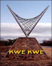
Kwekwe, formerly known as Que Que, is a city in the Midlands province in central Zimbabwe. The city has a population of 119,863 within the city limits, as of the 2022 census, making it the 7th-largest city in Zimbabwe and the second-most populous city in the Midlands, behind Gweru.
Macheke is a small Zimbabwean town located in Murewa District, province of Mashonaland East, located about 105 km south-east of Harare on the main A3 Harare-Mutare highway road. According to the 1982 population census, the town had a population of 1,888. It was named after the Macheke River and means "you have divided". Macheke is also the hometown of Wicknell Chivayo, a well known and controversial Zimbabwean businessman accused of government contract abuse during the rule of Robert Mugabe.
Chatsworth is a small settlement in the Masvingo Province of Zimbabwe. It is located about 58 km north of Masvingo on the Masvingo-Gweru railway line. The settlement started in 1911 as a railway station. It administered under the Gutu Rural District Council.

Tsholotsho, originally known as Tjolotjo, is a district in Matabeleland North province in Zimbabwe. Its administrative centre is at Tsholotsho business centre which is located about 98 km north-west of Bulawayo. Districts around Tsholotsho include Lupane, Hwange, Umguza, and Bulilima. The Manzamnyama River separates Tsholotsho from Bulilima District, whilst the Gwayi River separates it from Umguza and Lupane districts, and the Hwange National Park separates it from Hwange District.
Zhombe, originally known as Jombe, is a rural communal area in Kwekwe District, Midlands Province, Zimbabwe. It is an area of mixed Shona and Northern Ndebele People. It lies along the Mnyathi border line between Midlands and Mashonaland Provinces. There are a few commercial farms within its borders and a handful of resettlement areas. Most of it is within the Zhombe Constituency. Its administrative centre is the Zhombe Joel Growth Point, and it is under the Zibagwe Rural District Council.
Shurugwi Rural Areas, also known as Shurugwi District, is a rural area around Shurugwi, Zimbabwe, mainly to the east, beginning 20 kilometres from the town centre. The area between the town and the rural areas was mainly occupied by white commercial farmers. It is thought that at one time, these farms were owned by three families who were all related. The total area of these farms is approximately 60 km x 40 km similar to an area that was occupied by more than 4,000 African families. Most of the black families are subsistence farmers. Maize is generally grown by the majority.
This article gives lists of the National Monuments and other historic sites of Zambia, with a one- or two-line description providing links to details given on other pages.

Beitbridge is a district in Matabeleland South, Zimbabwe Situated 18 kilometers north of Musina and 548 kilometers north of Johannesburg. Beitbridge district is located in the Lowveld area. The town lies 6 km ESE of the confluence of the Bubye River and the Limpopo on the border with South Africa. It was established in 1929. The town has a population of approximately 43,000 and serves a district of 100,000 people. An estimated 60 percent of Beitbridge's population is female, reflecting extensive male migration to South Africa.
Uzumba-Maramba-Pfungwe, also known as UMP, is a district of Mashonaland East Province in Zimbabwe. It consists of the northern part of the pre-1969 larger Murehwa (Mrehwa) District and includes the village of Uzumba. The area is inhabited by the Budja Shona people. The staple food crop is maize, with secondary vegetable crops.
Mangwende is a dynasty from Southern Africa, Zimbabwe commonly known as Mangwende dynasty of Nhowe or Mangwende of Nhowe. It is the royal dynasty of the Nhowe people, who are a part of the Shona tribe now living in Murewa, Mashonaland East, Zimbabwe. The Mangwende dynasty was started by the patriarch of the Nhowe people, Sakubvunza in 1606 who established the Shona traditional state of Nhowe. The name Nhowe refers to the traditional state as well as the Nhowe people.

Columbina Rural Service Center is a populated place in Zhombe. It is 95 km northwest of Kwekwe and 67 km southwest of Kadoma.
Empress Mine Township is a populated place in the area formerly known as Salakuhle in Zhombe Communal Land, Kwekwe District of the Midlands Province in Zimbabwe. It is Zhombe's largest growth point yet officially it is rated second after Zhombe Joel, the current Zhombe District capital.

Ngondoma Dam is a dam on the Ngondoma River located 500 meters west of the Empress Mine Township in the Midlands Province of Zimbabwe. The dam is 67 kilometers northwest of the Kwekwe and 54 km southwest of Kadoma.

Gweru District is a district in the [[Midlands it is the center of Zimbabwe. .(Zimbabwe)|Midlands]] Province of Zimbabwe.
Joel Biggie Matiza was a Zimbabwean politician and the Minister of Transport and Infrastructural Development since 2018. He died from COVID-19 on 22 January 2021.

