
Lake Ladoga is a freshwater lake located in the Republic of Karelia and Leningrad Oblast in northwestern Russia, in the vicinity of Saint Petersburg.
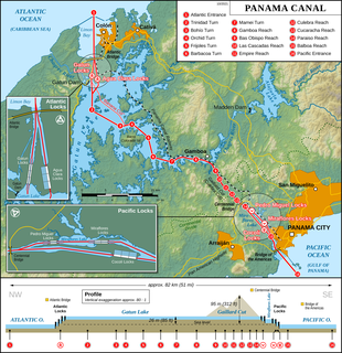
The Panama Canal is an artificial 82 km (51 mi) waterway in Panama that connects the Atlantic Ocean with the Pacific Ocean. The canal cuts across the Isthmus of Panama and is a conduit for maritime trade. Canal locks are at each end to lift ships up to Gatun Lake, an artificial lake created to reduce the amount of excavation work required for the canal, 26 m above sea level, and then lower the ships at the other end. The original locks are 34 m wide. A third, wider lane of locks was constructed between September 2007 and May 2016. The expanded canal began commercial operation on June 26, 2016. The new locks allow transit of larger, post-Panamax ships, capable of handling more cargo.

The Welland Canal is a ship canal in Ontario, Canada, connecting Lake Ontario and Lake Erie. It forms a key section of the St. Lawrence Seaway and Great Lakes Waterway. Traversing the Niagara Peninsula from Port Weller to Port Colborne, it enables ships to ascend and descend the Niagara Escarpment and bypass Niagara Falls.

Northern Savonia or, officially, Pohjois-Savo is a region in eastern Finland. It borders the regions of Etelä-Savo, Central Finland, North Ostrobothnia, Kainuu, and North Karelia. Kuopio is the largest city in the region.

The Vuoksi is a river running through the northernmost part of the Karelian Isthmus from Lake Saimaa in southeastern Finland to Lake Ladoga in northwestern Russia. The river enters Lake Ladoga in three branches, an older main northern branch at Priozersk (Käkisalmi), a smaller branch a few kilometres to the north of it, and a new southern branch entering 50 kilometres (31 mi) further southeast as Burnaya River, which has become the main stream in terms of water discharge. Since 1857, the old northern distributaries drain only the lower reaches of the Vuoksi basin and are not fed by Lake Saimaa. The northern and southern branches actually belong to two separate river systems, which at times get isolated from each other in dry seasons.

Ylöjärvi is a town and a municipality in the Pirkanmaa region, 14 kilometres (9 mi) west of Tampere and 189 kilometres (117 mi) north of Finland´s capital city Helsinki.
Päijänne Tavastia or, officially, Päijät-Häme is a region in Southern Finland south of the lake Päijänne. It borders the regions of Uusimaa, Tavastia Proper (Kanta-Häme), Pirkanmaa, Central Finland, Southern Savonia (Etelä-Savo) and Kymenlaakso. The biggest city in the region is Lahti.

The Saimaa Canal is a transportation canal that connects lake Saimaa with the Gulf of Finland near Vyborg, Russia. The canal was built from 1845 to 1856 and opened on 7 September 1856 . It was overhauled and widened in 1963–1968.

Lake Päijänne is the second largest lake in Finland. The lake drains into the Gulf of Finland via the Kymi River. The major islands are from north to south Vuoritsalo, Muuratsalo, Onkisalo, Judinsalo, Edessalo, Taivassalo, Haukkasalo, Vehkasalo, Mustassalo, Virmailansaari and Salonsaari. The largest island is Virmailansaari. The word saari means an island. Salo once meant a great island, nowadays it means a great forest area.

The Beauharnois Canal is a canal located in southwestern Quebec, Canada. The canal is part of the Saint Lawrence Seaway.
Varistaipale canal is a Finnish canal in Heinävesi. It is another of the canals which connects Juojärvi to Varisvesi. The canal is a part of Heinävesi route, a route with six canals: Kerma, Vihovuonne, Pilppa, Karvio, Taivallahti and Varistaipale canals. The canal was built in 1911–1913 and has four locks. It is the biggest canal in Finland being the only canal to have this many locks. The height of drop totals 14.5 metres (48 ft) and the length is 1,100 metres (3,600 ft).

Vääksy is a village and seat of the municipality of Asikkala in southern Finland. It is located on an isthmus between Päijänne and Vesijärvi, about 20 kilometres (12 mi) north of Lahti.

Mänttä-Vilppula is a town and municipality of Finland. The municipalities of Mänttä and Vilppula were consolidated into a single municipality on January 1, 2009. It is located in the Pirkanmaa region.
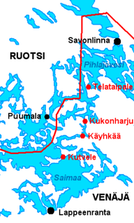
Suvorov military canals is a series of four open canals on Saimaa lake in Finland. The four canals of Kutvele, Käyhkää, Kukonharju and Telataipale are located in Puumala, Ruokolahti and Sulkava. They were built between 1791–1798 as part of the South-Eastern Finland fortification system and are the oldest canals in Finland. The canals are named after general Alexander Suvorov who ordered their construction.

Kaavinjärvi is a lake in eastern Finland. The surface area of the lake is approximately 21 square kilometres.
Tikankaivanto Canal is a canal between Pyhäselkä and Tikanselkä in Liperi, Finland. It was built in 1972 and its length is over 100 metres (330 ft). Maximum width of ships is 11.8 metres (39 ft) and draft 2.4 metres (7.9 ft).
Väärinmaja is a village in the municipality of Ruovesi in the Pirkanmaa region, Finland. The village of is known of the 1918 Finnish Civil War Battle of Väärinmaja. In 2008–2010, Väärinmaja hosted a stage of the World Rally Championship event Rally Finland.

The Battle of Ruovesi was a major battle during the Finnish Civil War and on the Eastern Front of World War I fought in Ruovesi, Finland from 5 February to 19 March 1918 between the Whites and the Reds with support from Russian volunteers.

Kaukajärvi is a Finnish lake in Pirkanmaa. The lake is 3.2 kilometres (2.0 mi) long, 950 metres (3,120 ft) wide and covers an area of 143 hectares. Its average depth is 12 metres (39 ft) and the maximum depth has been measured as 23 metres (75 ft).


