Musconetcong County, New Jersey

Last updated

Musconetcong County was a proposed county in New Jersey, which was to be created from parts of Hunterdon and Warren counties.

New Jersey State of the United States of America

New Jersey is a state in the Mid-Atlantic and Northeastern regions of the United States. It is located on a peninsula, bordered on the north and east by the state of New York, particularly along the extent of the length of New York City on its western edge; on the east, southeast, and south by the Atlantic Ocean; on the west by the Delaware River and Pennsylvania; and on the southwest by the Delaware Bay and Delaware. New Jersey is the fourth-smallest state by area but the 11th-most populous, with 9 million residents as of 2017, and the most densely populated of the 50 U.S. states; its biggest city is Newark. New Jersey lies completely within the combined statistical areas of New York City and Philadelphia. New Jersey was the second-wealthiest U.S. state by median household income as of 2017.

Hunterdon County, New Jersey County in the United States

Hunterdon County is a county located in the western section of the U.S. state of New Jersey. As of the 2017 Census estimate, the county's population was 125,059, making it the state's 18th-most populous county, representing a 2.6% decrease from the 128,349 enumerated in the 2010 United States Census, in turn increasing by 6,360 (+5.2%) from the 121,989 counted in the 2000 Census, retaining its position as the state's 14th-most populous county. The percentage increase in population of 13.2% between 1990 and 2000 was the largest in New Jersey, almost triple the statewide increase of 4.5%, and the absolute increase in residents was the third highest. Its county seat is Flemington.

Warren County, New Jersey County in the United States

Warren County is a county located in the U.S. state of New Jersey. As of the 2017 Census estimate, the county's population was 106,798, making it the 19th-most populous of the state's 21 counties, representing a decrease of 1.7% from the 108,692 enumerated in the 2010 United States Census, in turn having increased by 6,255 (+6.1%) from 102,437 counted at the 2000 Census, Its county seat is Belvidere. It is part of the Allentown-Bethlehem-Easton, PA-NJ metropolitan area and is generally considered the eastern border of the Lehigh Valley. It is considered part of the New York-Newark, NY-NJ-CT-PA Combined Statistical Area, and shares its eastern border with the New York City Metropolitan Area, with its northwestern section bordering The Poconos. The most populous place was Phillipsburg, with 14,950 residents at the time of the 2010 Census, while Hardwick Township, covered 37.92 square miles (98.2 km2), the largest total area of any municipality.

Contents

Boundaries

The 1852 New Jersey Senate Bill No. 97 describes the proposed county as follows:

New Jersey Senate

The New Jersey Senate was established as the upper house of the New Jersey Legislature by the Constitution of 1844, replacing the Legislative Council. There are 40 legislative districts, representing districts with average populations of 210,359. Each district has one senator and two members of the New Jersey General Assembly, the lower house of the legislature. Prior to the election in which they are chosen, senators must be a minimum of 30 years old and a resident of the state for four years to be eligible to serve in office.

Beginning at a point in the middle of the river Delaware dividing the states of Pennsylvania and New Jersey, where the Nishisakawick Creek empties into the said river, in the county of Hunterdon, and state of New Jersey, and running thence in the courses of the lines dividing the townships of Alexandria, Kingwood, Franklin and Bethlehem, in the said county of Hunterdon, to a point in the south branch of the Raritan river at the village of Clinton; thence following the course of the lines dividing the townships of Bethlehem, Clinton and Franklin, in the said county of Hunterdon, to a point in the Musconetcong river, forming the division line between the counties of Hunterdon and Warren; thence following the courses of the said Musconetcong river, dividing the township of Bethlehem, in the said county of Hunterdon, from the township of Washington, in the said county of Warren, to the line dividing the township of Franklin and Washington, in the said county of Warren, and running thence in the courses of the said lines dividing the said townships of Franklin and Washington, to a point in the township lines dividing the townships of Franklin, Washington, Oxford and Harmony, in the said county of Warren; thence by the courses of the lines dividing the townships of Franklin, Harmony, Greenwich and Phillipsburg, in the said county of Warren to a point in the middle of the said river Delaware; thence following the courses of the said river Delaware to the place of beginning, be, and the same is hereby erected into a separate county, to be called "The County of Musconetcong," and the said lines shall hereafter be the division lines between the counties of Hunterdon, Warren and Musconetcong. [1]

History

Introduced by Senator William Cowper Alexander (D-Mercer County) on February 18, 1852, Bill No. S97 received its first reading that day and was referred to the Judiciary Committee, from which it was reported without amendment the following day. Considered for second reading on March 4, it was amended and postponed to the next day, where the amendments were taken up by section, the bill ordered engrossed and a third reading ordered. On March 10 the Committee on Engrossed Bills reported its finding that the bill was correctly engrossed. On March 11, however, the Senate voted to postpone the bill to the next Legislature; it was never taken up again. [2]

William Cowper Alexander was an American lawyer, politician, and insurance executive. He served as President of the New Jersey State Senate and as President of the Equitable Life Assurance Society.

Democratic Party (United States) political party in the United States

The Democratic Party is one of the two major contemporary political parties in the United States, along with the Republican Party. Tracing its heritage back to Thomas Jefferson and James Madison's Democratic-Republican Party, the modern-day Democratic Party was founded around 1828 by supporters of Andrew Jackson, making it the world's oldest active political party.

Mercer County, New Jersey County in the United States

Mercer County is a county located in the U.S. state of New Jersey. Its county seat is Trenton, the state capital. The county constitutes the Trenton-Ewing, NJ Metropolitan Statistical Area and is considered part of the New York Metropolitan Area by the United States Census Bureau, but also directly borders the Philadelphia metropolitan area and is included within the Federal Communications Commission's Philadelphia Designated Market Area and the greater Philadelphia-Reading-Camden Combined Statistical Area. As of the 2017 Census estimate, the county's population was 374,733, making it the state's 12th-most populous county, an increase of 2.2% from the 2010 United States Census, when its population was enumerated at 366,513, in turn an increase of 15,752 (4.5%) from the 350,761 enumerated in the 2000 Census, retaining its position as the 12th-most populous county in the state.

Government

The proposed legislation designated Bloomsbury, then within Bethlehem Township, as the county seat. As in all counties in New Jersey, the governing body was to be the board of chosen freeholders. Musconetcong was to have its own sheriff, county clerk, surrogate and county prosecutor.

Bloomsbury, New Jersey Borough in New Jersey

Bloomsbury is a borough in Hunterdon County, New Jersey, United States. As of the 2010 United States Census, the borough's population was 870, reflecting a decline of 16 (-1.8%) from the 886 counted in the 2000 Census, which had in turn declined by 4 (-0.4%) from the 890 counted in the 1990 Census.

A county seat is an administrative center, seat of government, or capital city of a county or civil parish. The term is used in Canada, China, Romania, Taiwan and the United States. County towns have a similar function in the United Kingdom and Republic of Ireland, and historically in Jamaica.

In New Jersey, a board of chosen freeholders is the county legislature in each of the state's 21 counties.

Judicial functions were to have been performed by a circuit court, court of common pleas, court of quarter sessions and court of oyer and terminer.

Circuit courts are court systems in several common law jurisdictions. The core concept of circuit courts requires judges to travel to different locales to ensure wide visibility and understanding of cases in a region. More generally, some modern circuit courts may also refer to a court that merely holds trials for cases of multiple locations in some rotation.

The New Jersey Court of Common Pleas was a civil court of general jurisdiction, which existed in New Jersey from 1704 until 1947.

In English law, oyer and terminer was the Law French name for one of the commissions by which a judge of assize sat. The commission was also known by the Law Latin name audiendo et terminando, and the Old English-derived term soc and sac.

Municipalities

The following five municipalities were to be included in the proposed Musconetcong County:

Alexandria Township, New Jersey Township in New Jersey

Alexandria Township is a township in Hunterdon County, New Jersey, United States. As of the 2010 United States Census, the township's population was 4,938, reflecting an increase of 240 (+5.1%) from the 4,698 counted in the 2000 Census, which had in turn increased by 1,104 (+30.7%) from the 3,594 counted in the 1990 Census.

Bethlehem Township, New Jersey Township in New Jersey

Bethlehem Township is a township in Hunterdon County, New Jersey, United States. It is part of the New York metropolitan area. As of the 2010 United States Census, the township's population was 3,979, reflecting an increase of 159 (+4.2%) from the 3,820 counted in the 2000 Census, which had in turn increased by 716 (+23.1%) from the 3,104 counted in the 1990 Census.

Franklin Township, Warren County, New Jersey Township in New Jersey

Franklin Township is a township in Warren County, New Jersey, United States. As of the 2010 United States Census, the township's population was 3,176, reflecting an increase of 408 (+14.7%) from the 2,768 counted in the 2000 Census, which had in turn increased by 364 (+15.1%) from the 2,404 counted in the 1990 Census. The township is located in the far eastern region of the Lehigh Valley.

Municipalities later subdivided from the original five include:

Related Research Articles

New Jersey Route 31 highway in New Jersey

Route 31 is a state highway in New Jersey, United States. It runs 48.93 mi (78.75 km) from U.S. Route 1 Business /US 206 in Trenton, Mercer County, north to an intersection with US 46 in Buttzville in White Township, Warren County. Along the way, Route 31 heads through the communities of Flemington, Clinton and Washington. Most of the highway is state-maintained; however, the section within the city limits of Trenton is maintained by the city. Much of Route 31 is a two-lane highway that passes through farmland, woodland, and mountainous areas. Two portions of the route—from Trenton to Pennington and from Ringoes to Clinton—consist of more development.

Franklin Township, Hunterdon County, New Jersey Township in New Jersey

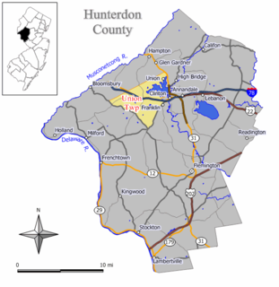
Franklin Township is a township in central Hunterdon County, New Jersey, United States. As of the 2010 United States Census, the township's population was 3,195, reflecting an increase of 205 (+6.9%) from the 2,990 counted in the 2000 Census, which had in turn increased by 139 (+4.9%) from the 2,851 counted in the 1990 Census. Most of the township lies on the Hunterdon Plateau with only the eastern section along the South Branch Raritan River being on the lower part of the Newark Basin.

Union Township, Hunterdon County, New Jersey Township in New Jersey, United States

Union Township is a township in Hunterdon County, New Jersey, United States. As of the 2010 United States Census, the township's population was 5,908, reflecting a decline of 252 (-4.1%) from the 6,160 counted in the 2000 Census, which had in turn increased by 1,082 (+21.3%) from the 5,078 counted in the 1990 Census. The southwest half of the township lies on what is known as the Hunterdon Plateau, the northwest corner consists of the Musconetcong Ridge and the northeast section is part of the lower-lying Newark Basin around Spruce Run Reservoir.

Lopatcong Township, New Jersey Township in New Jersey, United States

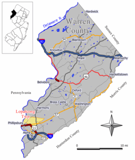
Lopatcong Township is a township in Warren County, New Jersey, United States. As of the 2010 United States Census, the township's population was 8,014, reflecting an increase of 2,249 (+39.0%) from the 5,765 counted in the 2000 Census, which had in turn increased by 713 (+14.1%) from the 5,052 counted in the 1990 Census. The township is part of the eastern region of the Lehigh Valley.

Phillipsburg, New Jersey Town in New Jersey, United States

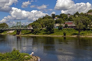
Phillipsburg is a town in Warren County, New Jersey, United States, a sister city to its industrial partner of Easton, Pennsylvania across the Delaware River.

Pohatcong Township, New Jersey Township

Pohatcong Township is a township in Warren County, New Jersey, United States. As of the 2010 United States Census, the township's population was 3,339, reflecting a decline of 77 (-2.3%) from the 3,416 counted in the 2000 Census, which had in turn declined by 175 (-4.9%) from the 3,591 counted in the 1990 Census. The name Pohatcong is said to be from the Lenni Lenape Native American term meaning "stream between split hills".

New Jersey Route 173 highway in New Jersey

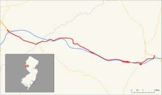
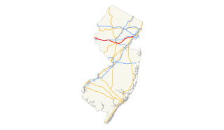
Route 173 is a state highway in New Jersey, United States that is a designation for an old section of U.S. Route 22. The route runs 14.62 mi (23.53 km) from Interstate 78 and U.S. Route 22 in Greenwich Township, Warren County to County Route 626 in Clinton Township, Hunterdon County, just east of an interchange with Route 31. Route 173 parallels Interstate 78 and U.S. Route 22 for its entire length through rural areas of Warren and Hunterdon Counties, passing through the towns of Bloomsbury and Clinton along the way. At one point just to the west of Clinton, Route 173 runs concurrent with Interstate 78 and U.S. Route 22.

Interstate 78 (I-78) is an east–west route stretching from Union Township, Lebanon County, Pennsylvania to New York City. In New Jersey, I-78 is called the Phillipsburg–Newark Expressway and the Newark Bay Extension of the New Jersey Turnpike. The highway runs for 67.83 miles (109.16 km) in the northern part of the state of New Jersey from the Interstate 78 Toll Bridge over the Delaware River at the Pennsylvania state line in Phillipsburg, Warren County east to the Holland Tunnel under the Hudson River at the New York state line in Jersey City, Hudson County. The Phillipsburg-Newark Expressway portion of I-78, formally called the Lightning Division Memorial Highway, runs from the Phillipsburg area east across rural areas of western New Jersey before entering suburban areas in Somerset County. The road crosses the Watchung Mountains, widening into a local-express lane configuration at Route 24 as it continues through urban areas to Newark. Here, I-78 intersects the mainline of the New Jersey Turnpike (I-95) and becomes the Newark Bay Extension, crossing the Newark Bay Bridge and continuing to Jersey City. The route, along with Route 139, follows a one-way pair of surface streets to the Holland Tunnel.

The Lopatcong Township School District is a comprehensive community public school district that serves students in pre-kindergarten through eighth grade from Lopatcong Township, in Warren County, New Jersey, United States.

The Greenwich Township School District is a comprehensive community public school district that serves students in pre-kindergarten through eighth grade from Greenwich Township, in Warren County, New Jersey, United States.

Skylands Region

The Skylands Region is a region and marketing area of the State of New Jersey located in the Northern and Central part of the state. It is one of six tourism regions established by the New Jersey State Department of Tourism, the others being the Gateway Region, Greater Atlantic City Region, the Southern Shore Region, the Delaware River Region and the Shore Region. The area officially encompasses Hunterdon, Morris, Somerset, Sussex and Warren counties; the northwestern part of the Passaic County fits in with the Skylands Region, but it is part of the Gateway Region and not the Skylands Region. One could also say that the western most part of Bergen is also part of the skylands. The area features uplifted land, rolling hills and mountains characteristic of North Jersey. The region contains 60,000 acres of state parkland, and a diverse geography filled with lakes, rivers and picturesque hills.

U.S. Route 22 in New Jersey highway in New Jersey

U.S. Route 22 is a U.S. highway stretching from Cincinnati, Ohio in the west to Newark, New Jersey in the east. In New Jersey, the route runs for 60.53 mi (97.41 km) from the Easton-Phillipsburg Toll Bridge over the Delaware River in Phillipsburg, Warren County to Interstate 78 (I-78), US 1/9, and Route 21 at the Newark Airport Interchange in Newark, Essex County. The road first heads through the Phillipsburg-Alpha area as a surface divided highway before running concurrent with I-78 through mountainous and agricultural sections of western New Jersey between Alpha and east of Clinton in Hunterdon County. For the remainder of the route, US 22 runs to the south of I-78 through mostly suburban areas as a four- to six-lane surface divided highway, passing through Hunterdon, Somerset, Union, and Essex counties. Along this portion, it intersects US 202 and US 206 in Somerville, I-287 in Bridgewater Township, and the Garden State Parkway in Union.

The Bloomsbury School District is a community public school district that serves students in pre-kindergarten through eighth grade from Bloomsbury, in Hunterdon County, New Jersey, United States.

The Alpha School District is a comprehensive community public school district that serves students in pre-kindergarten through eighth grade from Alpha, in Warren County, New Jersey, United States.

The Pohatcong Township School District is a comprehensive community public school district that serves students in pre-kindergarten through eighth grade from Pohatcong Township, in Warren County, New Jersey, United States.

Hunterdon Plateau

Hunterdon Plateau is a plateau in western Hunterdon County, New Jersey. It borders the higher Musconetcong Mountain to the northwest, the Delaware River to the west, Amwell Valley to the south and the lower lying areas of the Newark Basin to the east.

References

  1. New Jersey Senate; 1852 Session, Bill No. 97
  2. Journal of the New Jersey Senate, 1852; pp. 241, 274, 284, 425, 439, 477 and 493

Coordinates: 40°54′34″N74°42′51″W / 40.90952°N 74.71406°W / 40.90952; -74.71406