
Banitsa is a deserted village in Serres regional unit, northern Greece. Its ruins are situated some 15 km north-east of the town of Serres, near the present-day village of Oreini, on the southern slopes of the Vrontous mountains. During the Ottoman period it had a Bulgarian population. The village was destroyed by the Greek Army during the Second Balkan War, and the population migrated to Bulgaria. Its inhabitants settled in Mehomiya, Bachevo, Nevrokop, Sveti Vrach, and Novo Delchevo.
Vaklinovo is a village in Southwestern Bulgaria. It is located in the Satovcha Municipality, Blagoevgrad Province.

Zhizhevo is a village in Southwestern Bulgaria. It is located in the Satovcha Municipality, Blagoevgrad Province.

Kribul is a village in Southwestern Bulgaria. It is located in the Satovcha Municipality, Blagoevgrad Province.
Pletena is a village in Southwestern Bulgaria. It is located in the Satovcha Municipality, Blagoevgrad Province.
Fargovo is a village in Southwestern Bulgaria. It is located in the Satovcha Municipality, Blagoevgrad Province.
Slashten is a village in Southwestern Bulgaria. It is located in the Satovcha Municipality, Blagoevgrad Province.
Lyalevo or Lyalyovo is a former village in southernmost western Bulgaria which ceased to exist in 1960. Lyalevo is known as the only village within the modern borders of Bulgaria that was inhabited by Greek Muslims (Vallahades).
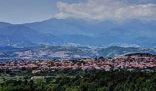
Krushevo is a compact mountainous village in Garmen Municipality, in Blagoevgrad Province, Bulgaria. It is situated in the Dabrash part of the Rhodope Mountains, 5 kilometers east of Garmen and 80 kilometers southeast of Blagoevgrad. The village is connected with the third class road from Gotse Delchev to Satovcha by a 2 kilometers of asphalt road going north from the main road and continuing to Oreshe.
Ognyanovo is a resort village with thermal mineral water springs in Garmen Municipality, in Blagoevgrad Province, Bulgaria.
Osikovo is a mountainous village in Garmen Municipality, in Blagoevgrad Province, Bulgaria. It is situated in the Dabrash part of the Rhodope Mountains, 11 kilometers north-northwest of Garmen and 66 kilometers southeast of Blagoevgrad.
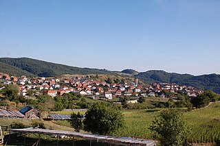
Ribnovo is an isolated mountainous village in Garmen Municipality, in Blagoevgrad Province, Bulgaria. It is situated in the Dabrash part of the Rhodope Mountains at 1152 meters altitude, 14 kilometers north-northwest from Garmen and 64 kilometers southeast of Blagoevgrad by air. The village can be reached by a 20 kilometers asphalt mountainous road from Ognyanovo through the villages Skrebatno and Osikovo.
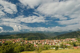
Breznitsa is a village in Gotse Delchev Municipality, in Blagoevgrad Province, Bulgaria. It is located 12 kilometers northwest of Gotse Delchev and 61 kilometers southeast of Blagoevgrad in the Pirin mountain. The Tufcha river is flowing by the village. A municipal asphalt road connects Breznitsa with the second class road Razlog - Gotse Delchev.

Delchevo is a village in Gotse Delchev Municipality, in Blagoevgrad Province, Bulgaria. The village is 3 kilometers southwest of Gotse Delchev and about 600 m higher in the Pirin mountain, 71 kilometers southeast of Blagoevgrad and is connected with the town of Gotse Delchev by a steep 8 kilometers long mountainous road, accessible during the whole year. There are a few permanent residents in the village. The only source of income is the touristic business. There aren't any industrial subjects in the village. The village has no school or community center.

Kornitsa is a village in Gotse Delchev Municipality, in Blagoevgrad Province, Bulgaria. It is situated 9 kilometers northwest of Gotse Delchev and 63 kilometers southeast of Blagoevgrad in the foothills of Pirin mountain. The river of Marevo flows through the village.

Lazhnitsa is a village in Gotse Delchev Municipality, in Blagoevgrad Province, Bulgaria. It is situated in the foothills of the Pirin mountain, 7 kilometers northwest of Gotse Delchev and 65 kilometers southeast of Blagoevgrad.
Koprivlen is a village in Hadzhidimovo Municipality, in Blagoevgrad Province, Bulgaria.
Beslen is a village in Hadzhidimovo Municipality, in Blagoevgrad Province, Bulgaria. It is situated just 2 km from the border with Greece.
Novo Leski is a village in Hadzhidimovo Municipality, in Blagoevgrad Province, Bulgaria.
Zaim Chiflik is a former village in the Gotse Delchev Municipality, Blagoevgrad District, Bulgaria. The village was situated about 3 kilometers south of Gotse Delchev, located alongside the former military airport of Musomishta.
