
Krishna district is a district in the coastal Andhra Region in Indian state of Andhra Pradesh, with Machilipatnam as its administrative headquarters. It is surrounded on the East by Bay of Bengal, West by Guntur, Bapatla and North by Eluru and NTR districts and South again by Bay of Bengal.

East Godavari is a district in the Coastal Andhra region of Andhra Pradesh, India. Its district headquarters is at Rajamahendravaram.

Coastal Andhra or Kosta Andhra is a geographic region in the Indian state of Andhra Pradesh. Vijayawada is the largest city in this region followed by Guntur. The region share borders with Rayalaseema region and North Andhra region of the state and Telangana. It was a part of Madras State before 1953 and Andhra State from 1953 to 1956. According to the 2011 census, it has an area of 91,915 square kilometres (35,489 sq mi) which is 57.99% of the total state area and a population of 34,193,868 which is 69.20% of Andhra Pradesh state population. This area includes the coastal districts of Andhra Pradesh on the Circar Coast between the Eastern Ghats and the Bay of Bengal, from the northern border with Uttarandhra to Rayalaseema in the south.

The West Godavari district is a coastal district in the Indian state of Andhra Pradesh with an administrative headquarters in Bhimavaram. As of the 2011 Census of India, the district has an area of 2,178 km2 (841 sq mi) and a population of 1,779,935. It is bounded by the Krishna district and Bay of Bengal to the south, East Godavari district to the east, and Eluru district, Kolleru Lake and Upputeru Drain to the northwest.

Eluru is a city and the district headquarters of Eluru district in the Indian state of Andhra Pradesh. It is one of the 14 municipal corporations in the state and the mandal headquarters of Eluru mandal in the Eluru revenue division. Situated on the banks of the Tammileru River, Eluru is strategically positioned in the southeastern part of Andhra Pradesh. It was historically known as Helapuri. As of 2011 Census of India, the city had a population of 214,414, reflecting its status as a major urban centre. The city's historical significance dates back to the second century CE, with evidence of its ancient roots found in various archaeological sites and historical records. Eluru was a prominent town under the rule of the Qutub Shahis, who governed the region in the 16th century. It came under the control of the Mughal Empire in the 17th century as the empire expanded its influence across South India. The town later became part of the Nawab of Hyderabad's dominions in the 18th century. During British India, Eluru was incorporated into the Madras Presidency and made capital for Northern Circars in the early 19th century. The British established administrative and infrastructural developments in the town, shaping its modern identity.

Khammam district is a district in the eastern region of the Indian state of Telangana. The city of Khammam is the district headquarters. The district shares boundaries with Suryapet, Mahabubabad, Bhadradri districts and with Eluru and NTR districts.

Ranga Reddy district is a district in the Indian state of Telangana. The district headquarters is located at Kongara Kalan Village, Ibrahimpatnam Mandal,. The district was named after the former deputy chief minister of the United Andhra Pradesh, K. V. Ranga Reddy. The district shares boundaries with Nalgonda, Yadadri Bhuvanagiri, Hyderabad, Medchal–Malkajgiri, Nagarkurnool, Mahabubnagar, Sangareddy and Vikarabad districts.
Nuzvid mandal is one of the 28 mandals in Eluru district of the Indian state of Andhra Pradesh. It is under the administration of Nuzvid revenue division, with headquarters at Nuzvid. MLA Name =Sree Kolusu Pardhasaradhi (TDP) | MPDO = Sree C. Raghavendra Nath( 9100084664) The mandal is bounded by Reddigudem, Vissannapeta, Chatrai, Mylavaram Agiripalli, Bapulapadu and Musunuru mandals.
Polavaram or Prolavaram is a village in Eluru district of the Indian state of Andhra Pradesh. It is located in Polavaram mandal of Jangareddygudem revenue division at about 35 km away from the banks of Godavari River. The Papi Hills and Polavaram Project are the major landmarks near the village.
Chintalapudi is a town municipality, constituency and mandal headquarters in Eluru District of the Indian state of Andhra Pradesh. Chintalapudi is one of oldest town in the Andhra Pradesh, but still it is under developed. There is no proper road and transport to the town. People of the town still struggling to reach the nearest cities. There is lot of history around this town, dates back to 600BC to 300BC.The human movement here from 2300 years ago. The village named Jeelakargudem is located 15 km away from here and contains some of the oldest ancient monuments in Buddhism. The carvings on the Sandrock hill are really surprising. According to the ASI and some historians the historical site belongs to Ashoka reign. The historical site is one of the best tourist attraction in the locality, but lack of proper care from government and people the site is ruining. This region is also famous for cultivation of Oil Plam. It's nearly contributes 50% to 60% of total district cultivation of Oil Palm. According to some sources this region contains a vast coal reserves in the country. Your can find more on this in some popular news journals.
Gullapudi is a village in Krishna district of the Indian state of Andhra Pradesh. It is located in Musunuru mandal of Nuzvid revenue division.
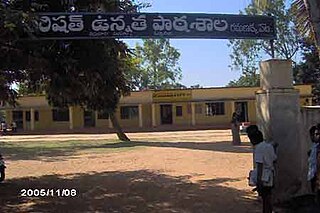
Balive is a village in the Eluru district of the Indian state of Andhra Pradesh. It is located in Musunuru Mandal, of Nuzvid revenue division. It is approximately 15 km from district headquarters Eluru city in Eluru District.
Eluru mandal is one of the 28 mandals in Eluru district of the Indian state of Andhra Pradesh. It is administered under Eluru revenue division and its headquarters are located at Eluru city. The mandal is bounded by Pedapadu mandal, Pedavegi mandal, Denduluru mandal, Bhimadole mandal and it also borders Krishna district.

Satrampadu is a census town in Eluru district of the Indian state of Andhra Pradesh. It is located in Eluru mandal of Eluru revenue division. The town is a constituent of Eluru urban agglomeration.
Pedapadu mandal is one of the 28 mandals in Eluru district of the Indian state of Andhra Pradesh having population of 76,793 as of 2011 census. It is administered under Eluru revenue division and its headquarters are located at Pedapadu.
Pinakadimi is a village in Eluru district of the Indian state of Andhra Pradesh. It is located in Pedavegi mandal of Eluru revenue division. It is located at a distance of 7 km from district headquarters Eluru city.
Lingapalem Mandal is one of 28 mandals in the Eluru district of Andhra Pradesh in India. Its headquarters are located in Lingapalem. It is bordered by T.Narasapuram and Chintalapudi in the North, Khammam district tin the West, Kamavarapukota mandal in the East, and Pedavegi mandal in the South.
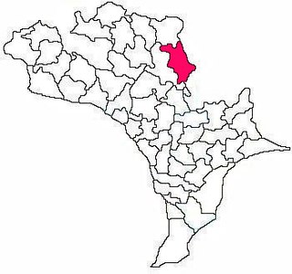
Musunuru mandal is one of the 28 mandals in the Eluru district of the Indian state of Andhra Pradesh.

Eluru district is a district in coastal Andhra Region in the Indian state of Andhra Pradesh. With Eluru as its administrative headquarters, it was proposed on 26 January 2022 to become one of the resultant twenty six districts in the state once a final notification is issued by the government of Andhra Pradesh. It is formed from Eluru revenue division and Jangareddygudem revenue division from West Godavari district and Nuzvid revenue division from Krishna district.
Kavali mandal is one of the 38 mandals in Nellore district of the Indian state of Andhra Pradesh. Its headquarters are located at Kavali. The mandal is bounded by .This mandal is located at Kavali revenue division.
Commanders of Kakatiya Army by NG Ranga.

