Bantumilli

Last updated

Bantumilli
Location map India Andhra Pradesh EN.svg
Red pog.svg
Bantumilli
Location in Andhra Pradesh, India
Coordinates: 16°21′00″N81°17′00″E / 16.3500°N 81.2833°E / 16.3500; 81.2833 Coordinates: 16°21′00″N81°17′00″E / 16.3500°N 81.2833°E / 16.3500; 81.2833
Country India
State Andhra Pradesh
District Krishna
Mandal Bantumilli
Area
[1]
  Total3.94 km2 (1.52 sq mi)
Elevation
0.5 m (1.6 ft)
Population
 (2011) [1]
  Total6,867
  Density1,700/km2 (4,500/sq mi)
Languages
  Official Telugu
Time zone UTC+5:30 (IST)
Vehicle registration AP–39

Bantumilli is a village in Krishna district of the Indian state of Andhra Pradesh. It is the mandal headquarters of Bantumilli mandal of Machilipatnam revenue division. [1] [2] It is well connected by Road.Its just 28Km from Machilipatnam,50Km from Bhimavaram,34Km from Gudivada. NH214A is connected over this Village.

Krishna district District of Andhra Pradesh in India

Krishna district is an administrative district in the Coastal Andhra region of the Indian state of Andhra Pradesh. Machilipatnam is the administrative headquarters and Vijayawada is the most populated city in the district. It has an area of 8,727 km2 (3,370 sq mi) and had a population of 45,29,009 as per 2011 census of India. It is bounded by West Godavari on the east, Bay of Bengal on the South, Guntur and Suryapet districts in the west and a portion of it also borders with the state of Telangana. Krishna District is formed from District of Rajahmundry in 1859, Guntur district was separated from Krishna in 1904 to form Krishna district which was further divided in 1925, to Krishna and West Godavari districts.Krishna district is the most developed district in Andhra Pradesh.

Andhra Pradesh State in southern India

Andhra Pradesh is one of the 29 states of India. Situated in the south-east of the country, it is the seventh-largest state in India, covering an area of 160,205 km2 (61,855 sq mi). As per the 2011 census, it is the tenth-most populous state, with 49,386,799 inhabitants. The largest city in Andhra Pradesh is Visakhapatnam. Telugu, one of the classical languages of India, is the major and official language of Andhra Pradesh.

Machilipatnam revenue division

Machilipatnam revenue division is an administrative division in the Krishna district of the Indian state of Andhra Pradesh. It is one of the four revenue divisions in the district with twelve mandals under its administration. Machilipatnam serves as the headquarters of the division. The division has 2 municipalities namely, Machilipatnam and Pedana. P.Saibaba is the present Revenue Divisional Officer of the division.

Contents

Avalibility

You can find each and every thing for our living aspects:Groceries, Clothes, Movie theater etc.,

Movie theater Venue, usually a building, for viewing films

A movie theater, cinema, or cinema hall, also known as a picture house, the pictures, or the movies is a building that contains auditoria for viewing films for entertainment. Most, but not all, theaters are commercial operations catering to the general public, who attend by purchasing a ticket. Some movie theaters, however, are operated by non-profit organizations or societies that charge members a membership fee to view films.

Geography

Bantumilli is located at 16°21′00″N81°17′00″E / 16.3500°N 81.2833°E / 16.3500; 81.2833 . [3] It has an average elevation of 0.5 metres (3 feet).

Demographics

As of 2011 census, the village had a population of 6,867 with 1,922 households. The total population constitute, 3,411 males and 3,456 females —a sex ratio of 1019 females per 1000 males. 673 children are in the age group of 0–6 years, of which 338 are boys and 335 are girls. The average literacy rate stands at 79.17% with 10,001 literates, significantly higher than the state average of 67.41%. [1] [4]

The decennial Census of India has been conducted 15 times, as of 2011. While it has been undertaken every 10 years, beginning in 1872 under british Viceroy Lord Ripon, the first complete census was taken in 1881. Post 1949, it has been conducted by the Registrar General and Census Commissioner of India under the Ministry of Home Affairs, Government of India. All the censuses since 1951 were conducted under the 1948 Census of India Act. The last census was held in 2011. The next will be held in 2021. Also it was 1st conducted at the time of industrial revolutions too

See also

Related Research Articles

Pedana Town in Andhra Pradesh, India

Pedana is a municipality and the headquarters of Pedana mandal under Machilipatnam revenue division of Krishna district of the Indian state of Andhra Pradesh. It is located at a distance of 8 km (5.0 mi) from the district headquarters, Machilipatnam.

Vuyyuru Town in Andhra Pradesh, India

Vuyyuru is a town in Krishna district of the Indian state of Andhra Pradesh.It is a Nagar panchayat and the headquarters of Vuyyuru Mandal under Nuzvid revenue division.

Gampalagudem Village in Andhra Pradesh, India

Gampalagudem is a village in Krishna district of the Indian state of Andhra Pradesh. It is the headquarters of Gampalagudem mandal administered under Nuzvid revenue division. The village is located on the banks of Kattaleru River, at a distance of 145 km (90 mi) from the district headquarters, Machilipatnam and 74 kilometres (46 mi) from Vijayawada.

Kankipadu Census Town in Andhra Pradesh, India

Kankipadu is a census town in Krishna district of the Indian state of Andhra Pradesh. It is also the mandal headquarters of Kankipadu mandal in Vijayawada revenue division. The town is located on the banks of the Paleru River which is a tributary of the Krishna River.

Nandivada Village in Andhra Pradesh, India

Nandivada is a village in Krishna district of the Indian state of Andhra Pradesh. It is located in Nandivada mandal of Gudivada revenue division. It is one of the villages in the mandal to be a part of Andhra Pradesh Capital Region.

Gudlavalleru Village in Andhra Pradesh, India

Gudlavalleru is a village and Mandal in Krishna district of the Indian state of Andhra Pradesh. It is located on the Gudivada – Machilipatnam route.

Challapalli Village in Andhra Pradesh, India

Challapalli, officially known as Challapalle, is a village in Krishna district of the Indian state of Andhra Pradesh. It is located in Challapalli mandal of Machilipatnam revenue division. Challapalli is one of the villages in the mandal to be a part of Andhra Pradesh Capital Region.

Nagayalanka Village in Andhra Pradesh, India

Nagayalanka is a village in Krishna district of Indian state of Andhra Pradesh. It is the mandal headquarters of Nagayalanka mandal in Machilipatnam revenue division.

Ibrahimpatnam, Krishna district Census Town in Andhra Pradesh, India

Ibrahimpatnam is a census town in Krishna district of the Indian state of Andhra Pradesh. It is also the mandal headquarters of Ibrahimpatnam mandal. Dr Narla Tata Rao Thermal Power Station, one of the major Thermal power stations of the state is located near the town. Railway Wagon Workshop at Rayanapadu is also located very near to Ibrahimpatnam at a distance of 4 km.

Machilipatnam mandal Mandal in Andhra Pradesh, India

Machilipatnam mandal is one of the 50 mandals in Krishna district of the Indian state of Andhra Pradesh. It is under the administration of Machilipatnam revenue division and the headquarters are located at Machilipatnam town. The mandal is bounded by Bantumilli, Pedana, Gudur, Ghantasala, Challapalli and Koduru mandals.

Machilipatnam (rural) Village in Andhra Pradesh, India

Machilipatnam (rural) is a village in Krishna district of the Indian state of Andhra Pradesh. It is located on the coast of Bay of Bengal in Machilipatnam mandal of Machilipatnam revenue division.

Nagayalanka mandal Mandal in Andhra Pradesh, India

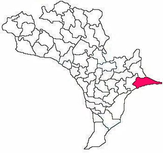
Nagayalanka mandal is one of the 50 mandals in Krishna district of the Indian state of Andhra Pradesh. It is under the administration of Machilipatnam revenue division and has its headquarters at Nagayalanka. The mandal is bounded by Avanigadda and Koduru mandals. It lies at the mouths of Krishna River where it empties into Bay of Bengal.

Edurumondi Village in Andhra Pradesh, India

Edurumondi is a village in Krishna district of Indian state of Andhra Pradesh. It is located in Nagayalanka mandal of Machilipatnam revenue division. The village is situated at the mouths of River Krishna, where it empties into Bay of Bengal.

Etimoga Village in Andhra Pradesh, India

Etimoga is a village in Krishna district of Indian state of Andhra Pradesh. It is located in Nagayalanka mandal of Machilipatnam revenue division. The village is situated at the mouths of River Krishna, where it empties into Bay of Bengal.

Mopidevi Lanka Village in Andhra Pradesh, India

Mopidevi Lanka is a village in Krishna district of the Indian state of Andhra Pradesh. It is located on the banks of Krishna River in Mopidevi mandal of Machilipatnam revenue division. It is a part of Andhra Pradesh Capital Region.

Kruthivennu mandal Mandal in Andhra Pradesh, India

Kruthivennu mandal is one of the 50 mandals in Krishna district of the Indian state in Andhra Pradesh. The headquarters of this mandal is located in the town of Kruthivennu. The mandal is bordered by Kalidindi mandal to the north, West Godavari district to the east, Bay of Bengal to the south and Bantumilli mandal to the west.

Bantumilli mandal Mandal in Andhra Pradesh, India

Bantumilli mandal is one of the 50 mandals in Krishna district of the Indian state of Andhra Pradesh. The headquarters of this mandal is located at Bantumilli town. The mandal is bordered by Kalidindi mandal to the north, Kruthivennu mandal to the east, Machilipatnam mandal to the south and Pedana mandal to the west.

Challapalli mandal Mandal in Andhra Pradesh, India

Challapalli mandal is one of the 50 mandals in the Krishna district of the Indian state of Andhra Pradesh. The headquarters of this mandal are located in Challapalli.

Guduru mandal, Krishna district Mandal in Andhra Pradesh, India

Guduru mandal is one of the 50 mandals in Krishna district of the Indian state of Andhra Pradesh. Its headquarters are located at Guduru. The mandal is bordered by Gudlavalleru mandal to the north, Pedana mandal to the east, Machilipatnam mandal to the south and Ghantasala mandal and Movva mandal to the west.

References

  1. 1 2 3 4 "District Census Handbook – Krishna" (PDF). Census of India. p. 16,364. Retrieved 15 February 2016.
  2. "Krishna District Mandals" (PDF). Census of India. pp. 502, 528. Retrieved 17 July 2015.
  3. Falling Rain Genomics, Inc – Bantumilli
  4. "Literacy of AP (Census 2011)" (PDF). Official Portal of Andhra Pradesh Government. p. 43. Archived from the original (PDF) on 14 July 2014. Retrieved 5 September 2014.