Koduru కోడూరు | |
|---|---|
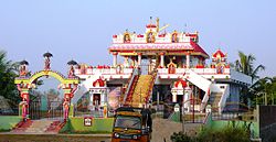 Ayyappa Swamy Temple | |
 Interactive map of Koduru | |
 Koduru Location in Andhra Pradesh, India | |
| Coordinates: 16°00′08″N81°02′30″E / 16.00222°N 81.04167°E | |
| Country | India |
| State | Andhra Pradesh |
| District | Krishna |
| Mandal | Koduru |
| Government | |
| • Type | Gram panchayat |
| Area | |
• Total | 35.33 km2 (13.64 sq mi) |
| Elevation | 7 m (23 ft) |
| Population (2011) [2] | |
• Total | 20,000 |
| • Density | 570/km2 (1,500/sq mi) |
| Languages | |
| • Official | Telugu |
| Time zone | UTC+5:30 (IST) |
| PIN | 521 328 |
| Telephone code | +91–8671 |
| Vehicle registration | AP 16 U |
| Website | www.koduru.com (under construction) |
Koduru is a village in Krishna district of the Indian state of Andhra Pradesh. [1] It is the Mandal headquarters of Koduru Mandal in Machilipatnam Revenue Division. Nearby villages are V. Kothapalem, Machavaram, Jayapuram.