
Spanish or Castilian (castellano) is a Romance language of the Indo-European language family that evolved from the Vulgar Latin spoken on the Iberian Peninsula of Europe. Today, it is a global language with about 500 million native speakers, mainly in the Americas and Spain, and about 600 million when including speakers as a second language. Spanish is the official language of 20 countries, as well as one of the six official languages of the United Nations. Spanish is the world's second-most spoken native language after Mandarin Chinese; the world's fourth-most spoken language overall after English, Mandarin Chinese, and Hindustani (Hindi-Urdu); and the world's most widely spoken Romance language. The country with the largest population of native speakers is Mexico.

Jammu and Kashmir was a region formerly administered by India as a state from 1952 to 2019, constituting the southern and southeastern portion of the larger Kashmir region, which has been the subject of a dispute between India, Pakistan and China since the mid-20th century. The underlying region of this state were parts of the former princely state of Jammu and Kashmir, whose western districts, now known as Azad Kashmir, and northern territories, now known as Gilgit-Baltistan, are administered by Pakistan. The Aksai Chin region in the east, bordering Tibet, has been under Chinese control since 1962.

The United States had an official estimated resident population of 334,914,895 on July 1, 2023, according to the U.S. Census Bureau. This figure includes the 50 states and the District of Columbia but excludes the population of five unincorporated U.S. territories as well as several minor island possessions. The United States is the third most populous country in the world. The Census Bureau showed a population increase of 0.4% for the twelve-month period ending in July 2022, below the world average annual rate of 0.9%. The total fertility rate in the United States estimated for 2022 is 1.665 children per woman, which is below the replacement fertility rate of approximately 2.1.

Suffolk County is located in the Commonwealth of Massachusetts, in the United States. As of the 2020 census, the population was 797,936, making it the fourth-most populous county in Massachusetts. The county comprises the cities of Boston, Chelsea, Revere, and Winthrop. The traditional county seat is Boston, the state capital and the largest city in Massachusetts. The county government was abolished in 1999, and so Suffolk County today functions only as an administrative subdivision of state government and a set of communities grouped together for some statistical purposes. Suffolk County is located at the core of the Boston-Cambridge-Newton, MA-NH Metropolitan Statistical Area as well as the greater Boston-Worcester-Providence, MA-RI-NH-CT Combined Statistical Area.
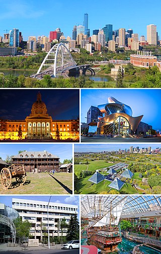
Edmonton is the capital city of the Canadian province of Alberta. Edmonton is situated on the North Saskatchewan River and is the centre of the Edmonton Metropolitan Region, which is surrounded by Alberta's central region. The city anchors the northern end of what Statistics Canada defines as the "Calgary–Edmonton Corridor", a region spanning between Edmonton and the city of Calgary, Alberta’s largest city, which includes the many smaller municipalities between the two.
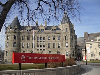
Winnipeg is the capital and largest city of the province of Manitoba in Canada. It is centred on the confluence of the Red and Assiniboine rivers, near the longitudinal centre of North America. As of 2021, Winnipeg had a city population of 749,607 and a metropolitan population of 834,678, making it Canada's sixth-largest city and eighth-largest metropolitan area.
Ferguson is a city in St. Louis County, Missouri, United States. It is part of the Greater St. Louis metropolitan area. Per the 2020 census, the population was 18,527, and predominantly black.

White Americans are Americans who identify as white people. This group constitutes the majority of the people in the United States. According to the 2020 census, 71%, or 235,411,507 people, were White alone or in combination, and 61.6%, or 204,277,273 people, were White alone. This represented a national white demographic decline from a 72.4% white alone share of the U.S. population in 2010.

Australian Bureau of Statistics (ABS) is an Australian government agency that collects and analyses statistics on economic, population, environmental, and social issues to advise the government.

The 2011 Canadian census was a detailed enumeration of the Canadian population on May 10, 2011. Statistics Canada, an agency of the Canadian government, conducts a nationwide census every five years. In 2011, it consisted of a mandatory short form census questionnaire and an inaugural National Household Survey (NHS), a voluntary survey which replaced the mandatory long form census questionnaire; this substitution was the focus of much controversy. Completion of the census is mandatory for all Canadians, and those who do not complete it may face penalties ranging from fines to prison sentences.
Patibandla. Chandrasekhara Rao was an Indian jurist. He was from Veerullapadu Village Guntur-Krishna District region of coastal Andhra Pradesh of what was then called Madras Presidency.

The 2011 census of India or the 15th Indian census was conducted in two phases, house listing and population enumeration. The House listing phase began on 1 April 2010 and involved the collection of information about all buildings. Information for National Population Register (NPR) was also collected in the first phase, which will be used to issue a 12-digit unique identification number to all registered Indian residents by Unique Identification Authority of India. The second population enumeration phase was conducted between 9 and 28 February 2011. Census has been conducted in India since 1872 and 2011 marks the first time biometric information was collected. According to the provisional reports released on 31 March 2011, the Indian population increased to 1.21 billion with a decadal growth of 17.70%. Adult literacy rate increased to 74.04% with a decadal growth of 9.21%. The motto of the census was Our Census, Our Future.

Jagannadhapuram is a village in NTR District of the Indian state of Andhra Pradesh. It is located in veerullapadu mandal of Nandigama revenue division.
Kanchikacherla mandal is one of the 20 mandals in NTR district of the Indian state of Andhra Pradesh. It is under the administration of Vijayawada revenue division and the headquarters are located at Kanchikacherla. The mandal is bounded Veerullapadu, Chanderlapadu and Ibrahimpatnam mandals. A portion of it lies on the banks of Krishna river, separating it from Guntur district and also Munneru river separates it from Nandigama mandal.
Veerullapadu mandal is one of the 20 mandals in the NTR district of the Indian state of Andhra Pradesh. Its headquarters is located in Veerullapadu village.

Jammu and Kashmir is a region administered by India as a union territory and consists of the southern portion of the larger Kashmir region, which has been the subject of a dispute between India and Pakistan since 1947 and between India and China since 1959. The Line of Control separates Jammu and Kashmir from the Pakistani-administered territories of Azad Kashmir and Gilgit-Baltistan in the west and north. It lies to the north of the Indian states of Himachal Pradesh and Punjab and to the west of Ladakh which is administered by India as a union territory.

Nandigama revenue division is an administrative division in the NTR district of the Indian state of Andhra Pradesh. It is one of the 3 revenue divisions in the district with 7 mandals under its administration and is formed on 4 April 2022 as part of a reorganisation of districts in the state. Nandigama serves as the headquarters of the division.

