Related Research Articles
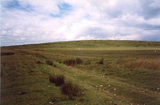
Clun Forest is a remote, rural area of open pastures, moorland and mixed deciduous/coniferous woodland in the southwest part of the English county of Shropshire and also just over the border into Powys, Wales.
The geology of Shropshire is very diverse. Rock formations dated to most geological periods of time, and many rock types, can be found within the county. There is also a large amount of mineral wealth in the county, including lead, baryte, limestone, coal and iron, which helped the area develop the industrial revolution west of Clee Hill and, later, in the Ironbridge Gorge area. Quarrying is still active, with limestone for cement manufacture and concrete aggregate, sandstone, greywacke and dolerite for road aggregate, and sand and gravel for aggregate and drainage filters. Groundwater is an equally important economic resource.

The geology of Wales is complex and varied; its study has been of considerable historical significance in the development of geology as a science. All geological periods from the Cryogenian to the Jurassic are represented at outcrop, whilst younger sedimentary rocks occur beneath the seas immediately off the Welsh coast. The effects of two mountain-building episodes have left their mark in the faulting and folding of much of the Palaeozoic rock sequence. Superficial deposits and landforms created during the present Quaternary period by water and ice are also plentiful and contribute to a remarkably diverse landscape of mountains, hills and coastal plains.
The Lachlan Fold Belt (LFB) or Lachlan Orogen is a geological subdivision of the east part of Australia. It is a zone of folded and faulted rocks of similar age. It dominates New South Wales and Victoria, also extending into Tasmania, the Australian Capital Territory and Queensland. It was formed in the Middle Paleozoic from 450 to 340 Mya. It was earlier known as Lachlan Geosyncline. It covers an area of 200,000 km2.

Fforest Fawr is an extensive upland area in the county of Powys, Wales. Formerly known as the Great Forest of Brecknock in English, it was a royal hunting area for several centuries but is now used primarily for sheep grazing, forestry, water catchment and recreation. It lies within the Brecon Beacons National Park.
Fforest Fawr Geopark is a Geopark in the Brecon Beacons National Park, south Wales. It is the first designated Geopark in Wales having gained membership of both the European Geoparks Network and the UNESCO-assisted Global Network of National Geoparks in October 2005. The Geopark aims to promote and support sustainable tourism and other opportunities to improve the economy of the area whilst safeguarding the natural environment. Its aims largely coincide with the statutory duties and purpose of the National Park within which it sits.
The Cribarth Disturbance is a geological structure forming a lineament which stretches across south Wales from Swansea up the Swansea Valley then northeastwards to Brecon and beyond. It consists of both a series of faults and associated folds which were active during the mountain-building period known as the Variscan orogeny. This line of weakness probably featured in the earlier Caledonian Orogeny and perhaps reflects a more ancient line of weakness in the basement rocks. It is also known as the Tawe Valley Disturbance or the Swansea Valley Disturbance.

Trichrug is a hill four miles east of Llandeilo and 3 miles south of Llangadog in the county of Carmarthenshire, southwest Wales. It lies within the Brecon Beacons National Park and Fforest Fawr Geopark. Its summit at a height of 415m above sea level is marked by a trig point. It is a Marilyn with a prominence of 191 metres.

Mynydd Myddfai is a hill 4.5 miles southeast of Llandovery in the county of Carmarthenshire, southwest Wales. It lies within the Brecon Beacons National Park and Fforest Fawr Geopark. The hill is in the form of a broad ridge aligned southwest to northeast with three or four distinct tops separated by cols. The northwest side drops steeply away towards the village of Myddfai whilst the other side is a more shallow slope down towards Glasfynydd Forest which encircles Usk Reservoir. The plateau surface of the hill rises to a height of 440m at OS grid ref SN 806297 where a trig point has been erected.
Mynydd Bach Trecastell is a hill on the border between the counties of Carmarthenshire and Powys in southwest Wales. It lies within the Black Mountain (range) of the Brecon Beacons National Park and Fforest Fawr Geopark. Its summit is plateau-like and reaches a height of 412m at OS grid ref SN 827312 at Y Pigwn. The name signifies the 'little hill of castle town'.
The Welsh Borderland Fault System is a zone of faulting and associated folding which runs northeastwards through Wales from Pembrokeshire through Carmarthenshire and Powys into Shropshire in England. It comprises the Tywi Lineament, Pontesford Lineament and Church Stretton Fault Zone. The southern margin of the fault system is defined by the Church Stretton Fault and Dulas Valley Fault, amongst others whilst its northern margin is defined by the Garth-Llanwrtyd Fault Belt in Carmarthenshire. The Church Stretton Fault component of the system is deemed to form the terrane boundary between the Cymru Terrane to its northwest and the Wrekin Terrane to its southeast.
In geology, a disturbance is a linear zone of disturbed rock strata stretching for many miles across country which comprises a combination of folding and faulting. The British Geological Survey record a number of such features in South Wales including the Neath Disturbance, Pontyclerc Disturbance, Carreg Cennen Disturbance and the Cribarth Disturbance, the latter sometimes also known as the Tawe Valley or Swansea Valley Disturbance. The southwestward continuation of the Carreg Cennen Disturbance is known as the Llandyfaelog Disturbance.
The geology of Monmouthshire in southeast Wales largely consists of a thick series of sedimentary rocks of different types originating in the Silurian, Devonian, Carboniferous, Triassic and Jurassic periods.
The geology of Romania is structurally complex, with evidence of past crustal movements and the incorporation of different blocks or platforms to the edge of Europe, driving recent mountain building of the Carpathian Mountains. Romania is a country located at the crossroads of Central, Eastern, and Southeastern Europe. It borders the Black Sea to the southeast, Bulgaria to the south, Ukraine to the north, Hungary to the west, Serbia to the southwest, and Moldova to the east.
The geology of national parks in Britain strongly influences the landscape character of each of the fifteen such areas which have been designated. There are ten national parks in England, three in Wales and two in Scotland. Ten of these were established in England and Wales in the 1950s under the provisions of the National Parks and Access to the Countryside Act 1949. With one exception, all of these first ten, together with the two Scottish parks were centred on upland or coastal areas formed from Palaeozoic rocks. The exception is the North York Moors National Park which is formed from sedimentary rocks of Jurassic age.
This article describes the geology of the Brecon Beacons National Park in mid/south Wales. The area gained national park status in 1957 with the designated area of 1,344 km2 (519 sq mi) including mountain massifs to both the east and west of the Brecon Beacons proper. The geology of the national park consists of a thick succession of sedimentary rocks laid down from the late Ordovician through the Silurian and Devonian to the late Carboniferous period. The rock sequence most closely associated with the park is the Old Red Sandstone from which most of its mountains are formed. The older parts of the succession, in the northwest, were folded and faulted during the Caledonian orogeny. Further faulting and folding, particularly in the south of the park is associated with the Variscan orogeny.
Mynydd Garnclochdy is a gentle summit on the long moorland ridge which extends south from Blorenge towards Pontypool and which defines the boundary between the modern county of Monmouthshire to the east and the county borough of Torfaen to the west though historically it was entirely within the traditional county of Monmouthshire. Its summit, at a height of 448 m (1407 ft), is marked by a small cairn. The summit and the eastern slopes of the hill fall within the Brecon Beacons National Park. A southern top of the hill, Mynydd Garn-wen achieves a height of 436m, and carries a trig point further south again at an elevation of 425m. To the north the broad moorland ridge runs via a poorly defined 425m top and a col at 404m elevation just south of a minor east–west road, into Mynydd y Garn-fawr, east of Blaenavon.
The geology of Snowdonia National Park in North Wales is dominated by sedimentary and volcanic rocks from the Cambrian and Ordovician periods with intrusions of Ordovician and Silurian age. There are Silurian and Cenozoic sedimentary rocks on the park's margins. The succession was intensely faulted and folded during the Caledonian Orogeny. The region was uplifted as the North Atlantic Ocean opened during the Cenozoic. The current mountainous landscape arises from repeated glaciations during the Quaternary period.
The bedrock geology of Carmarthenshire in west Wales consists largely of Palaeozoic age sedimentary rocks. Unconsolidated deposits of Quaternary age in Carmarthenshire include a dissected cover of glacial till, valley floor alluvium and some scattered peat deposits in both upland and lowland settings. There are extensive beach and tidal flat deposits along the Carmarthenshire coast. The exploitation of the county's mineral riches, particularly coal and limestone, was a key part of the local economy through much of the nineteenth and twentieth centuries.
The geology of Pembrokeshire in Wales inevitably includes the geology of the Pembrokeshire Coast National Park which extends around the larger part of the county’s coastline and where the majority of rock outcrops are to be seen. Pembrokeshire’s bedrock geology is largely formed from a sequence of sedimentary and igneous rocks originating during the late Precambrian and the Palaeozoic era, namely the Ediacaran, Cambrian, Ordovician, Silurian, Devonian and Carboniferous periods, i.e. between 635 and 299 Ma. The older rocks in the north of the county display patterns of faulting and folding associated with the Caledonian Orogeny. On the other hand, the late Palaeozoic rocks to the south owe their fold patterns and deformation to the later Variscan Orogeny.
References
- ↑ British Geological Survey 1:50,000 map sheets 196 'Builth Wells', 212 'Llandovery', 213 'Brecon' and 230 'Ammanford' & accompanying sheet explanations
- ↑ Ordnance Survey Explorer map OL12 'Brecon Beacons National Park: western area'
- ↑ Martin Allbutt (November 2002). "A field study of the Clun Forest Disturbance" (PDF). Shropshiregeology.org.uk. Retrieved 17 January 2019.