
Ceredigion is a principal area of Wales, corresponding to the historic county of Cardiganshire. During the second half of the first millennium Ceredigion was a minor kingdom. It has been administered as a county since 1282. Welsh is spoken by more than half the population. Ceredigion is considered to be a centre of Welsh culture. The county is mainly rural with over 50 miles (80 km) of coastline and a mountainous hinterland. The numerous sandy beaches and the long-distance Ceredigion Coast Path provide excellent views of Cardigan Bay.

Devil's Bridge is a village and community in Ceredigion, Wales. Above the River Mynach on the edge of the village is the unusual road bridge from which the village gets its English name.

Ponterwyd is a village in Ceredigion, Wales. It lies in the Cambrian Mountains of Mid Wales, approximately 12 miles (19 km) east of Aberystwyth on the A44 road.

Ystrad Aeron is a small village west of Felinfach on the A482 between Lampeter and Aberaeron, Ceredigion, Wales. It is part of the constituent community of Llanfihangel Ystrad.
Aber-banc is a village in the Welsh county of Ceredigion.

Llanilar is a village and community in Ceredigion, Wales, about 4 kilometres (2.5 mi) southeast of Aberystwyth. It is the eponym of the hundred of Ilar. The population at the 2011 census was 1,085.

Tan-y-Bwlch beach near Aberystwyth, Wales, forms part of the Pen Dinas and Tan-y-Bwlch Local Nature Reserve (LNR). The majority of which is located in the village of Penparcau. The area was designated in 1999 following a public meeting which attracted more than 100 local people. The 100-acre (0.40 km2) site contains the Bronze Age burial mound and Iron Age Hillfort named Pen Dinas. The site is managed by Ceredigion County Council and is publicly owned, it is the largest Local nature reserve in the Dyfi Biosphere. The Wales Coastal Path runs along the top of the shingle beach. The beach is sometimes referred to as Penparcau Beach by locals in the area, the name is used on some mapping services.
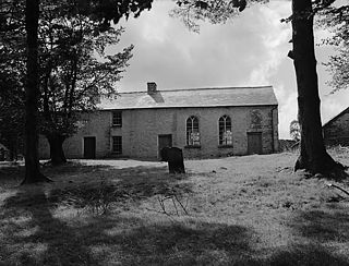
Soar-y-mynydd or Soar y mynydd is a Calvinist Methodist chapel near the eastern extremity of the large parish of Llanddewi Brefi, Ceredigion. Its often-repeated claim to fame is that it is the remotest chapel in all Wales. Its name is Welsh for ‘Zoar of the mountain’. Zoar or its Welsh equivalent Soar is a not uncommon chapel name in Wales which derives from the mention in Genesis 19:20–30 of the place which served as a sanctuary for Lot and his daughters and which was spared by God when the cities of Sodom and Gomorrah were destroyed.

Cynwyl Gaeo is a parish and community located in rural Carmarthenshire, Wales, near the boundary with Ceredigion, in the upper Cothi valley about halfway between Lampeter and Llandovery. The population of the village at the United Kingdom Census 2011 was 940. It includes the villages of Caeo, Crug-y-bar, Cwrtycadno, Ffarmers and Pumsaint.

Llangeler is a hamlet and community located in north Carmarthenshire, Wales. The name is believed to refer to St. Gelert. Llangeler parish covers a wide area including to the west, the textile village of Drefach Felindre, Waungilwen, Cwmpengraig and to the east, Pont Tyweli which adjoins Llandysul on the Carmarthenshire side of the River Teifi. The population of the parish was 3,222 at the Census of 2001, increasing to 3,427 at the 2011 census.

Llanfihangel-y-Creuddyn is an ancient parish in the upper division of the hundred of Ilar, Ceredigion, West Wales, 7 miles south east from Aberystwyth, on the road to Rhayader, comprising the chapelry of Eglwys Newydd, or Llanfihangel y Creuddyn Uchaf, and the township of Llanfihangel y Creuddyn Isaf. It was also known as Lower Llanfihangel y Creuddyn, Lower Llanfihangel y Croyddin and Lower Llanfihangel y Croyddyn. This parish is situated on the rivers Ystwyth, Mynach and Rheidol and intersected by various other streams. An ancient parish was a village or group of villages or hamlets and the adjacent lands. Originally they held ecclesiastical functions, but from the sixteenth century onwards they also acquired civil roles. The parish may have been established as an ecclesiastical parish. Originally a medieval administrative unit, after 1597 ecclesiastical units acquired civil functions with the Elizabethan Poor Laws, which made the parishes responsible for welfare. The civil function was exercised through vestry meetings which administered the Poor Law and were responsible for local roads and bridges.
Mynydd Bach is located in the midlands of Ceredigion. It is a range of low hills, rather than a single mountain as its name suggests. The highest point reaches 329 meters above sea level. This area contains a few small villages and is an important place in Ceredigion’s cultural history.

Creuddyn was a medieval commote and, later, a lordship in Ceredigion, Wales. It was located between the rivers Ystwyth and Rheidol, and was one of the three commotes of Cantref Penweddig. The name, of Old Welsh origin, probably refers to the Pen Dinas hill fort, anciently known as Dinas Maelor. The natural centre of the commote was Llanfihangel y Creuddyn where five roads meet at the village. The name survives in the name of a rural community and church of the same name; however the modern community is much smaller than the medieval commote.

Ffostrasol is a small village in the south of Ceredigion, Wales. It is located on the A486 between Synod Inn and Llandysul, and it forms part of the parish of Troedyraur. The village lies on a rural crossroad connecting it with the nearby village of Plwmp to the north, Synod Inn to the north east, Newcastle Emlyn to the south west, and Llandysul to the south east.

Silian, originally Sulien, is a village in the valley of the River Teifi, Ceredigion, Wales. It is located approximately two miles north-west of Lampeter, on a minor road connecting Pont Creuddun on the A482, and Glan Denys on the A485.
Llanafan is a small village between Tregaron and Aberystwyth, Ceredigion, in Wales. Llanafan is around ten miles from Aberystwyth and Tregaron. It is named for its parish church, St Afan's, which serves as the chapel for the nearby Trawsgoed Estate. Its eponymous saint supposedly founded the settlement in the 7th century. The village also has a hall and primary school founded in 1856 by Ernest Vaughan, 4th Earl of Lisburne, for which it was originally known as the Earl of Lisburne School.

Cwmsymlog is a short valley, sheltering a hamlet of the same name, in Ceredigion, in the west of Wales. This site lost much of its importance when the mining in the area declined and finally came to an end in 1901. It is also the name of a Site of Special Scientific Interest at that location.
Llansantffraid or Llansantffraed is a small rural village and community and practically merged with the village of Llanon just west of the main A487 Coastal Road between Aberaeron and Aberystwyth, about eleven miles from Aberystwyth. The population in 2001 was 1,241, declining to 1,212 at the 2011 census.
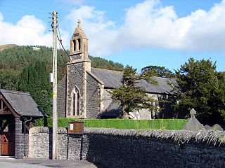
Blaenplwyf is a village in Ceredigion, to the southwest of Aberystwyth. It is noted for the Blaenplwyf transmitting station, which serves Aberystwyth and Cardigan Bay area. It was originally built by the BBC in 1956–7, serving as a main transmitter for BBC Band II VHF FM radio. Blaenplwyf contains a small stone and brick former Mission Church, dated to 1878, which is now a church. The Calvinistic Methodist Chapel, a yellow and brown Victorian church built by David Williams of Aberystwyth, also dates to 1878.
