Myklebost Syvde | |
---|---|
Village | |
Location in Møre og Romsdal | |
Coordinates: 62°05′00″N05°44′04″E / 62.08333°N 5.73444°E Coordinates: 62°05′00″N05°44′04″E / 62.08333°N 5.73444°E | |
Country | Norway |
Region | Western Norway |
County | Møre og Romsdal |
District | Sunnmøre |
Municipality | Vanylven Municipality |
Area [1] | |
• Total | 0.76 km2 (0.29 sq mi) |
Elevation [2] | 10 m (30 ft) |
Population (2012) [1] | |
• Total | 393 |
• Density | 517/km2 (1,340/sq mi) |
Time zone | CET (UTC+01:00) |
• Summer (DST) | CEST (UTC+02:00) |
Post Code | 6140 Syvde |
Myklebost or Syvde is a village in Vanylven Municipality in Møre og Romsdal county, Norway. The village is located at the end of the Syvdsfjorden about 12 kilometres (7.5 mi) east of the municipal center of Fiskåbygd and 16 kilometres (9.9 mi) south of the village of Rovdane. The 0.76-square-kilometre (190-acre) village has a population (2012) of 393, giving the village a population density of 517 inhabitants per square kilometre (1,340/sq mi). [1]
Møre og RomsdalUrban East Norwegian: [²møːrə ɔ ˈrʊmsdɑːl](
Norway, officially the Kingdom of Norway, is a Nordic country in Northern Europe whose territory comprises the western and northernmost portion of the Scandinavian Peninsula; the remote island of Jan Mayen and the archipelago of Svalbard are also part of the Kingdom of Norway. The Antarctic Peter I Island and the sub-Antarctic Bouvet Island are dependent territories and thus not considered part of the kingdom. Norway also lays claim to a section of Antarctica known as Queen Maud Land.
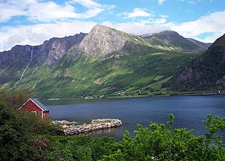
Syvdsfjorden is a fjord in Vanylven Municipality in Møre og Romsdal county, Norway. The 10-kilometre (6.2 mi) long fjord flows from the village of Myklebost to the north until it empties into the Rovdefjorden. The old Syvde municipality was centered on this fjord until it was merged into Vanylven municipality in 1964. The sides of the fjord are mountainous, particularly the eastern side, with mountainsides stretching up to 800 metres (2,600 ft) high coming right out of the water.
The village was the administrative centre for the old municipality of Syvde which existed from 1918 until 1964 when it was merged into Vanylven Municipality. The main church for the Syvde area is Syvde Church, located in Myklebost, right along the fjord.
An administrative centre is a seat of regional administration or local government, or a county town, or the place where the central administration of a commune is located.
Syvde is a former municipality in Møre og Romsdal county, Norway. The municipality included the areas surrounding the Syvdsfjorden in the eastern part of the present-day Vanylven Municipality. The 125-square-kilometre (48 sq mi) municipality existed from 1918 until 1964. The administrative centre of the municipality was the village of Myklebost, at the end of the fjord. Syvde Church was the municipal church.
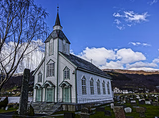
Syvde Church is a parish church in Vanylven Municipality in Møre og Romsdal county, Norway. It is located in the village of Myklebost in the Syvde area of the municipality. The church is part of the Vanylven parish in the Søre Sunnmøre deanery in the Diocese of Møre. The white, wooden church was built in 1837. It seats about 392 people.
Vanylven is a municipality in Møre og Romsdal county, Norway. It is part of the Sunnmøre region. The administrative centre is the village of Fiskåbygd. Other villages in the municipality include Sandnes, Åheim, Åram, Rovdane, Eidså, Slagnes, and Myklebost.
Sande is a municipality in Møre og Romsdal county, Norway. It is part of the Sunnmøre region. The administrative centre is the village of Larsnes on the island of Gurskøya. Other villages in Sande include Gursken, Sandshamn, Bringsinghaug, and Voksa.
Haram is a municipality in Møre og Romsdal county, Norway. It is part of the Sunnmøre region. The administrative center is Brattvåg, the industrial center of Sunnmøre. Other important villages in the municipality include Austnes, Eidsvik, Helle, Longva, Hildrestranda, Søvik, Tennfjord, and Vatne.
Sandøy is an island municipality in Møre og Romsdal county, Norway. It is part of the Romsdal region. The administrative centre is the village of Steinshamn. Other villages include Ona and Myklebost. The municipality is spread out over many islands in the mouth of Romsdal Fjord. The Flatflesa Lighthouse and Ona Lighthouse protect the boats traveling around the municipality. The Nordøy Fixed Link project is scheduled to be constructed from 2018 until 2023 and it will include three undersea tunnels and several bridges that will connect the main islands of Sandøy Municipality and the islands of Haram Municipality to the mainland.
Steinshamn is the administrative centre of Sandøy Municipality in Møre og Romsdal county, Norway. The village is located at the northern end of the island of Harøya. There is a causeway that connects Steinshamn to the neighboring island of Finnøya to the northeast.
Myklebost or Myklebust is a village in Ålesund Municipality in Møre og Romsdal county, Norway. It is located on the south side of the island of Ellingsøya, about 4 kilometres (2.5 mi) west of the village of Årset and about 5 kilometres (3.1 mi) east of the village of Hoffland. Myklebost is about 10 kilometres (6.2 mi) northeast of the city center of Ålesund.
Hoffland or Hovland is a village in Ålesund Municipality in Møre og Romsdal county, Norway. The village is located on the western end of the island of Ellingsøya, about 3 kilometres (1.9 mi) northeast of the town of Ålesund and about 5 kilometres (3.1 mi) west of the village of Myklebost.
Myklebost is the name of the following places:
Fiskåbygd or Fiskå is a coastal village that is also the administrative centre of Vanylven Municipality in Møre og Romsdal county, Norway. The village is located about 100 kilometres (62 mi) southwest of the city of Ålesund, about 12 kilometres (7.5 mi) east of the village of Myklebost, and about 30 kilometres (19 mi) southwest of the village of Rovdane. Fiskåbygd lies along the shores of the Vanylvsfjorden, east of the Stadlandet peninsula in Selje Municipality.
Rovdane is a village in Vanylven Municipality in Møre og Romsdal county, Norway. It is located along the Rovdefjorden, about 15 kilometres (9.3 mi) north of the village of Myklebost, 27 kilometres (17 mi) northeast of the municipal center of Fiskåbygd, and 20 kilometres (12 mi) west of the village of Volda. The district around Rovdane is referred to as Rovdestranda. Rovde Church is located in Rovdane.
Rovde is a former municipality in Møre og Romsdal county, Norway. The 53-square-kilometre (20 sq mi) municipality existed from 1905 until 1964. Rovde included the area on both the north and south sides of the Rovdefjorden. The northern area on the island of Gurskøya is currently part of Sande Municipality and the southern area is part of Vanylven Municipality. Rovde Church was the main church for the municipality.
Kvamsøya is an island in the municipality of Sande in Møre og Romsdal county, Norway. It is located 6 kilometres (3.7 mi) east of the Stad peninsula in Selje Municipality and about 7 kilometres (4.3 mi) west of the village of Larsnes on the island of Gurskøya. The island lies in the Vanylvsgapet, the entrance to the Vanylvsfjorden.
Fjørtofta is the northernmost island in Haram Municipality in Møre og Romsdal county, Norway. The 8.9-square-kilometre (3.4 sq mi) island is located in the northern part of the municipality, between the islands of Flemsøya, Harøya, and Midøya and Dryna.
Myklebost is a village on the southern end of Harøya island in Sandøy Municipality in Møre og Romsdal county, Norway. The village is about 7 kilometres (4.3 mi) south of the municipal center of Steinshamn. There are ferry connections from Myklebost to Fjørtofta and Brattvåg in Haram Municipality and to Dryna in Midsund Municipality. The Myklebost area was a part of Haram Municipality until 1965. Harøy Church is located about 5 kilometres (3.1 mi) north of the village.
Årset is a village in Ålesund Municipality in Møre og Romsdal county, Norway. The village is located along the Ellingsøyfjorden on the southern shore of the island of Ellingsøya, about 4 kilometres (2.5 mi) east of the village of Myklebost and about 12 kilometres (7.5 mi) west of the village of Tennfjord in Haram Municipality.
Åram is a village in Vanylven Municipality in Møre og Romsdal county, Norway. The village is located on the mainland, about 12 kilometres (7.5 mi) straight north of the municipal centre of Fiskåbygd. The village has a ferry quay with regular connections to the nearby islands of Kvamsøya, Voksa, and Gurskøya. Åram Church is located in the village.
This Møre og Romsdal location article is a stub. You can help Wikipedia by expanding it. |