
The Black Mountains are a group of hills spread across parts of Powys and Monmouthshire in southeast Wales, and extending across the England–Wales border into Herefordshire. They are the easternmost of the four ranges of hills that comprise the Brecon Beacons National Park, and are frequently confused with the westernmost, which is known as the Black Mountain. The Black Mountains may be roughly defined as those hills contained within a triangle defined by the towns of Abergavenny in the southeast, Hay-on-Wye in the north and the village of Llangors in the west. Other gateway towns to the Black Mountains include Talgarth and Crickhowell. The range of hills is well known to walkers and ramblers for the ease of access and views from the many ridge trails, such as that on the Black Hill (Herefordshire) at the eastern edge of the massif.
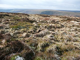
Coity Mountain is a flat-topped mountain in the South Wales Valleys, between Blaenavon and Abertillery. The highest points of both Torfaen and Blaenau Gwent unitary authorities are at the summit of Coity Mountain. The summit is also known as Twyn Ffynhonnau Goerion. Some 2 km (1 mi) to the southeast lies a major subsidiary top of the hill, Mynydd Varteg Fawr (549m) at the southeastern end of whose broad ridge is a trig point at 544m. A few hundred metres to the southeast of this summit is a memorial known as the "Dog Stone" which commemorates Carlo the Red Setter, a dog shot accidentally by his master while hunting on the 12 August 1864. Co-ordinates for the Dog Stone 51.45'15.58N 3.05'08.81W. Other notable tops include those of Mulfran (524m) which overlooks the town of Brynmawr and Mynydd James immediately east of the town of Blaina.

Cefn yr Ystrad is a mountain in the Brecon Beacons National Park in Wales. It is an outlier of the Central Beacons group.

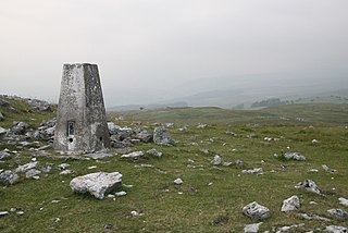
Mynydd Llangatwg or Llangattock Mountain is a hill in the Brecon Beacons National Park in the county of Powys, south Wales. It is named from the village of Llangatwg which sits in the valley of the River Usk to the north of it. It is essentially an undulating plateau rising in the west to a height of 530 metres (1,740 ft) at grid reference SO171157 and in the east to a height of 529 metres (1,736 ft) at Hen Dy-aderyn / Twr Pen-cyrn. This spot is marked by a trig point. The shallow pool of Pwll Gwy-rhoc sits in a broad depression towards the northern edge of the plateau whilst a smaller pool frequently occupies a large shakehole a few hundred metres to its west. The hill forms an impressive northern scarp overlooking the Usk valley and commonly referred to as the Llangattock Escarpment. Its southern margins are more subdued. Its eastern end is defined by the drops into the Clydach Gorge. Beyond the B4560 to the west the hill merges with Mynydd Llangynidr which has a similar character.

Foel Fraith is a hill in the Black Mountain in the county of Carmarthenshire, southwest Wales. It lies within the Brecon Beacons National Park and Fforest Fawr Geopark. Its plateau-like summit attains a height of 602 metres (1,975 ft) above sea level. To the north the subsidiary summit of Cefn y Cylchau reaches 556 feet (169 m), and to the southeast is the subsidiary summit of Carn Fadog or Cefn Carn Fadog, which reaches a height of 512 metres (1,680 ft).
Cefn Cil Sanws is a hill in the Brecon Beacons National Park within the county borough of Merthyr Tydfil in south Wales. The summit at 460m above sea level is crowned by a trig point. The steep cliffs of Darren Fawr and Darren Fach defend its western side which drops down into Cwm Taf. A major limestone quarry is worked on the southeastern side of the hill. An unexpected feature at this altitude is Merthyr Tydfil Golf Course which extends high onto the eastern and southern slopes of the hill.
Cadair Fawr is a hill in the northern corner of the county borough of Rhondda Cynon Taf, Wales. It lies within the Brecon Beacons National Park and Fforest Fawr Geopark. The 485m high summit at OS grid ref SN 978123 is marked by a trig point. Cadair Fawr is the highest point of a broad ridge known as Cefn Cadlan which forms the northern edge of Cwm Cadlan, a valley which itself runs east-northeastwards from the village of Penderyn. The name Cadair Fawr signifies the 'big chair' whilst Cefn Cadlan signifies the 'ridge of the battlefield'.
Cefn Manmoel is the name given to the broad ridge of high ground between the Sirhowy Valley and Ebbw Vale in the Valleys region of South Wales. It straddles the boundary between the unitary areas of Caerphilly and Blaenau Gwent.

Mynydd Merthyr is a broad ridge of high ground between Taff Vale and the Cwm Cynon in the Valleys region of South Wales. It forms the boundary between the unitary authorities of Rhondda Cynon Taff to the west and Merthyr Tydfil to the east.

Mynydd Cilfach-yr-encil attains a height of 445m at OS grid reference SO 079033 making it the high point of the broad ridge of high ground between Taff Vale and Cwm Bargod in the Valleys region of South Wales. It lies within the unitary area of Merthyr Tydfil.
Mynydd Bedwellte is the name given to the broad ridge of high ground between the Rhymney Valley and the Sirhowy Valley in the Valleys region of South Wales. It straddles the boundary of the unitary areas of Caerphilly and Blaenau Gwent.
Cefn y Brithdir is the name given to the broad ridge of high ground between the Rhymney Valley and Cwm Darran in the Valleys region of South Wales. It lies within the unitary area of Caerphilly.

Mynydd y Drum is a hill on the border between the county of Powys and Neath Port Talbot County Borough, south Wales. The summit of the hill is in Neath Port Talbot at 298m and lies towards the western end of a broad curving ridge, the larger part of which is in Powys. The eastern half of the hill is currently being opencasted for coal. The hill is sometimes referred to simply as The Drum.
Hirfynydd is a 481-metre-high hill in Neath Port Talbot county borough in South Wales. A Roman road, Sarn Helen, runs along its entire northeast–southwest ridge-line, a route followed by a modern-day byway. To its west is Cwm Dulais and to its southeast is the Vale of Neath. The northern end of the ridge falls away to a broad upland vale containing the Afon Pyrddin and beyond which is the Brecon Beacons National Park.
Cefn Eglwysilan is a hill in South Wales, the twin 382m summits of which lie 2 km east of Pontypridd in Rhondda Cynon Taf county borough. Its eastern side lies within the community of Aber Valley in Caerphilly county borough. Like neighbouring Mynydd Eglwysilan, the hill is named after the hamlet of Eglwysilan, the church here being dedicated to an obscure saint Ilan. A wireless transmission station is sited on the more northerly of the two summits. The southerly one is crowned by a trig point.
Mynydd Eglwysilan is a 355-metre-high hill in the Caerphilly county borough in South Wales 3 km to the south of Nelson and a similar distance southwest of Ystrad Mynach. To its south is Senghenydd at the head of the Aber Valley. Like neighbouring Cefn Eglwysilan, the hill is named after the hamlet of Eglwysilan 4 km to the southwest, the church here being dedicated to an obscure Saint Ilan. Remains of a linear earthwork known as Senghenydd Dyke stretch across the southern side of the hill. It is considered to mark the edge of an extensive 13th-century deer park associated with nearby Caerphilly Castle.
Cefn Gwyngul is a long broad ridge to the east of the Rhondda Fach valley in Rhondda Cynon Taf County Borough in South Wales. Its 470m high summit is marked by an ancient cairn known as Carn-y-Pigwn, on which is a more recent trig point. Much of the hill is cloaked by modern forestry plantations though its southwestern flank between Porth and Ferndale has not been coniferised. The earthworks of a Roman camp remain on the ridge at OS grid ref ST 002982.

Mynydd Twyn-glas is a sprawling 472-metre-high mountain extending into Caerphilly and Torfaen county boroughs in South Wales. It lies southwest of Pontypool, west of Cwmbran and east of Newbridge and taking the form of a rolling plateau the margins of which are defined by steep slopes, many of which are cloaked with conifer plantations. A broad shoulder extending south from the summit is known as Mynydd Maen whilst to the north is Mynydd Llwyd. The thickly afforested northern slopes of the hill drop down steeply into Cwm y Glyn.
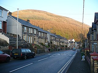
Mynydd y Lan is a 381-metre-high flat-topped hill in Caerphilly county borough in South Wales. It falls largely within the community of Ynysddu but its northern and eastern margins are within Crosskeys community. Its largely wooded southern and eastern flanks rise steeply from the Sirhowy and Ebbw valleys respectively. A wireless transmission station is located towards the northern end of the summit plateau.
Mynydd y Grug is a hill lying just west of the village of Cwmfelinfach and about 4 km to the northeast of Caerphilly in Caerphilly county borough in South Wales. Its summit was formerly at a height of around 358 m, but since the top has been covered by a large spoil heap and landscaped its height has now increased to 375 m, though some authorities take other values for the summit height. A number of ancient cairns are found along its edge overlooking the Sirhowy Valley, the slopes up from which are largely wooded.
