
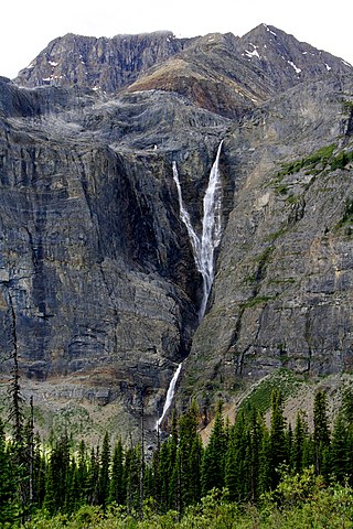
Della Falls is a waterfall located within Strathcona Provincial Park on Vancouver Island in British Columbia, Canada. With a total height of 440 m (1,440 ft), it ranks as the 16th tallest confirmed waterfall in Canada and the second tallest on Vancouver Island after Kiwi Falls in Schoen Lake Provincial Park.

Davis Lake Provincial Park is a 185 acres (0.75 km2) park in British Columbia, Canada, established as a protected provincial park in October 1963. It is located east of the southern end of Stave Lake, northeast of Mission, British Columbia, approximately 18 km north on Sylvester Rd from BC Highway 7. There are campgrounds and beaches at the south end of the lake, access is walk-in only via a 1 km unmaintained gravel road.
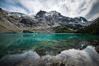
Joffre Lakes Provincial Park is a class A provincial park located 35 kilometres (22 mi) east of Pemberton in British Columbia, Canada. It was established in 1996, when Joffre Lakes Recreation Area was upgraded to park status.
Monkman Provincial Park is a provincial park in British Columbia, southwest of Tumbler Ridge and northeast of Hansard. Like Monkman Pass, Monkman Lake, Monkman Creek and Monkman Falls, it was named after Alexander Monkman.

The Golden Hinde is a mountain located in the Vancouver Island Ranges on Vancouver Island, British Columbia, Canada. At 2,195 metres (7,201 ft), it is the highest peak on the island. The peak is popular with experienced backcountry-climbers, having been first ascended in 1913. The mountain is made of basalt which is part of the Karmutsen Formation.

Rolley Lake Provincial Park is a provincial park in British Columbia, Canada. It is located on Rolley Lake in the Stave Falls area of Mission, British Columbia. The area was inhabited by the Sto:lo people, homesteaded in 1888 by James and Fanny Rolley, and later used for logging operations. The park now provides campsites, use of the lake, and hiking, with an area of 115 hectares.
Schoen Lake Provincial Park is a provincial park in northeastern Vancouver Island, British Columbia, Canada, located east of the community of Woss Lake and southwest of Sayward. The park lies inside the Nimpkish Valley watershed. On October 28, 1977, the "Class A" park was officially created to protect, exhibit and interpret an example of the natural features and processes of the Insular Mountains Natural Region. The park covers a total area of 8,775 hectares. Within those hectares of park land is a number of lakes, creeks and mountain ranges.

Shannon Falls Provincial Park is a provincial park in British Columbia, Canada. It is located 58 kilometers (36 mi) from Vancouver and 2 kilometers (1.2 mi) south of Squamish along the Sea to Sky Highway.

Strathcona Provincial Park is the oldest provincial park in British Columbia, Canada, and the largest on Vancouver Island. Founded in 1911, the park was named for Donald Alexander Smith, 1st Baron Strathcona and Mount Royal, a wealthy philanthropist and railway pioneer. It lies within the Strathcona Regional District. The Clayoquot Sound Biosphere Reserve, established in 2000, includes three watersheds in the western area of the park.

Strathcona-Westmin Provincial Park is a Class B provincial park located at the southern extremity of Buttle Lake on Vancouver Island in British Columbia, Canada. The park was separated out from Strathcona Provincial Park by BC Parks in 1987 so that mining operations could proceed within park boundaries. Strathcona-Westmin is expected to be reabsorbed into Strathcona Provincial Park once mining operations cease.

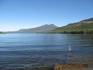
Great Central Lake is a lake on Vancouver Island, British Columbia, Canada. It is located north of Sproat Lake and to the northwest of the city of Port Alberni. It is 45 kilometres (28 mi) long, with an area of 50.85 square kilometres (19.63 sq mi) and mean depth of 124 metres (407 ft), to a maximum of 250 metres (820 ft), making it the second deepest lake on Vancouver Island. The lake is long and narrow, with the exception of Trestle Bay located on the east end of the lake. It is nestled beneath low mountains, with second-growth forest surrounding most of the lake. The water level is controlled by a dam on the east side.

Buttle Lake is a lake on Vancouver Island in Strathcona Regional District, British Columbia, Canada. It is about 23 kilometres (14 mi) long and 1.5 kilometres (0.9 mi) wide, has an area of 28 square kilometres (11 sq mi), is up to 120 metres (394 ft) deep, and lies at an elevation of 221 metres (725 ft). The lake is located between Campbell River and Gold River in Strathcona Provincial Park. The lake is the headwaters of the Campbell River.
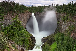
Helmcken Falls is a 141 m (463 ft) waterfall on the Murtle River within Wells Gray Provincial Park in British Columbia, Canada. The protection of Helmcken Falls was one of the reasons for the creation of Wells Gray Provincial Park in 1939.

Cortes Island is an island in the Discovery Islands archipelago on the coast of British Columbia, Canada. The island is 25 km (16 mi) long, 13 km (8 mi) wide, and 130 km2 (50 sq mi) in area. It has a population of 1,035 permanent residents. Cortes Island lies within Electoral Area B of the Strathcona Regional District, which provides water and sewerage systems, fire protection, land use planning, parks, recreation, and emergency response.

Buntzen Lake is a 4.8 kilometres (3 mi) long lake in Anmore, British Columbia, Canada, in the Greater Vancouver area. It is named after the first general manager of the B.C. Electric Co., Johannes Buntzen. There is a smaller lake just to the north named McCombe Lake.
Mahood Lake is a lake in the South Cariboo region of the Interior of British Columbia in Wells Gray Provincial Park. It is drained by the Mahood River, a tributary of the Clearwater River which has cut a deep canyon into Cambrian rocks and Pleistocene glacial moraines. Mahood Lake is fed by the short Canim River, which drains nearby Canim Lake to the west via Canim Falls and Mahood Falls.

Mount Septimus is the western summit of a jagged mountain on Vancouver Island, British Columbia, Canada, located 50 km (31 mi) southeast of Gold River and 10 km (6 mi) south of Buttle Lake. It contains a huge glacier on the north flank. The highest peak on the massif is Mount Rosseau, located 600 m (1,969 ft) to the west.

Hunlen Falls is a waterfall located at the mouth of Turner Lake in the Pacific Ranges of British Columbia, Canada. With an estimated height of 260 m (850 ft), it is tied with Takakkaw Falls in Yoho National Park for having the fourth tallest single drop of any waterfall in Canada.

Upper Campbell Lake is a reservoir on Vancouver Island in British Columbia, Canada. The lake was flooded in 1958 for a large hydroelectric project, which raised the water level by 30 metres (98 ft). Crest Creek and headwaters of the Heber River are diverted into the lake. Part of the lake and its watershed is located in Strathcona Provincial Park, and the Strathcona Park Lodge is located on the eastern side. Freshwater fish species in the lake include Cutthroat trout, Rainbow trout and Dolly varden.
Helmet Falls is a tiered waterfall located in Kootenay National Park in British Columbia, Canada. With total height of 352 metres (1,155 ft), Helmet Falls is the 11th tallest confirmed waterfall in the Canadian Rockies, as well as one of the most significant waterfalls in British Columbia based on both height and volume.


