
Porvoo is a city in Finland. It is located on the south coast of the country, on the Gulf of Finland. Porvoo lies in the eastern part of the Uusimaa region. The population of Porvoo is approximately 52,000, while the sub-region has a population of approximately 60,000. It is the 19th most populous municipality in Finland, and the 15th most populous urban area in the country.

Southern Finland was a province of Finland from 1997 to 2009. It bordered the provinces of Western Finland and Eastern Finland. It also bordered the Gulf of Finland and Russia.
Nurmijärvi is a municipality in Finland, located in the southern interior of the country. Nurmijärvi is situated in the Uusimaa region. The population of Nurmijärvi is approximately 45,000. It is the 26th most populous municipality in Finland and the most populous municipality without city status. Nurmijärvi is part of the Helsinki metropolitan area, which has approximately 1.6 million inhabitants.

Alajärvi is a town and municipality of Finland. It is located in the South Ostrobothnia region. The town has a population of 9,095 and covers an area of 1,056.74 square kilometres (408.01 sq mi) of which 47.99 km2 (18.53 sq mi) is water. The population density is 9.02 inhabitants per square kilometre (23.4/sq mi). The town is unilingually Finnish.
Askola is a municipality of Finland. It is located in the Uusimaa region. The municipality has a population of 4,679 and covers an area of 218.03 square kilometres (84.18 sq mi) of which 5.61 km2 (2.17 sq mi) is water. The population density is 22.03 inhabitants per square kilometre (57.1/sq mi). Monninkylä is the largest village of the municipality in terms of population. Neighbouring municipalities are Myrskylä, Mäntsälä, Pornainen, Porvoo and Pukkila.
Äänekoski is a town in Finland. It is located in the Central Finland region, about 45 kilometres (28 mi) north of Jyväskylä, the region's capital city. Äänekoski has a population of 17,786, as of 31 August 2024, and covers an area of 1,138.39 square kilometres (439.53 sq mi) of which 253.84 km2 (98.01 sq mi), or 22%, is water. The population density is 20.11 inhabitants per square kilometre (52.1/sq mi).
Uusimaa is a region of Finland. It borders the regions of Southwest Finland, Tavastia Proper (Kanta-Häme), Päijänne Tavastia (Päijät-Häme), and Kymenlaakso. Finland's capital and largest city, Helsinki, along with the surrounding metropolitan area, are both contained in the region, and Uusimaa is Finland's most populous region. The population of Uusimaa is 1,734,000.
Hausjärvi is a municipality of Finland. Its seat is in Oitti.

Iitti is a municipality of Finland. It is located in the province of Southern Finland and is part of the Päijänne Tavastia region. The municipality has a population of 6,433 and covers an area of 687.09 square kilometres (265.29 sq mi) of which 97.27 km2 (37.56 sq mi) is water. The population density is 10.91 inhabitants per square kilometre (28.3/sq mi). Neighbour municipalities are Heinola, Kouvola, Lapinjärvi, Lahti and Orimattila. The municipality is unilingually Finnish.
Järvenpää is a town in Finland, located in the southern interior of the country. Järvenpää is situated in the centre of the Uusimaa region. The population of Järvenpää is approximately 47,000. It is the 24th most populous municipality in Finland. Järvenpää is part of the Helsinki Metropolitan Area, which has approximately 1.6 million inhabitants.

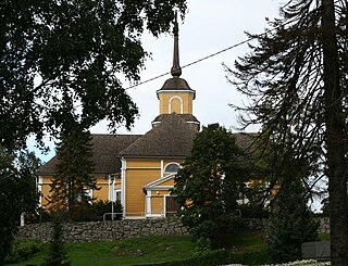
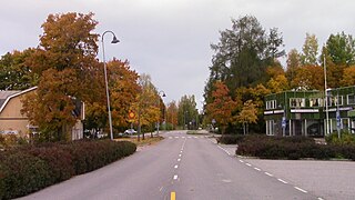
Myrskylä is a municipality in Finland, located in the southern interior of the country. Myrskylä is situated in the eastern part of the Uusimaa region, and it is the smallest municipality in the region in relation to its population. The population of Myrskylä is approximately 2,000, while the sub-region has a population of approximately 60,000. It is the 272nd most populous municipality in Finland.
Nastola is a former municipality of Finland. It was merged with the city of Lahti on 1 January 2016.

Orivesi is a town in Finland, located in the Pirkanmaa region. It lies to the northeast of the regional capital, Tampere. The population of Orivesi is approximately 9,000, while the metropolitan area has a population of approximately 421,000. It is the 111th most populous municipality in Finland.

Vampula is a former municipality of Finland. It was consolidated with Huittinen on 1 January 2009.
Kiikka is a locality and former municipality in Pirkanmaa region, Finland. It was consolidated in 1981 with Keikyä into a municipality of Äetsä, which in turn, was consolidated with Vammala and Mouhijärvi into a town of Sastamala in 2009. Kiikka is located by the river Kokemäenjoki, about 10 kilometres south of the Sastamala town center.
Kankaanpää is a village located in the municipality of Säkylä. It was previously located in the former municipality of Köyliö. There is a Royal Fountain in Kankaanpää, which was named after King Gustav III of Sweden. In 2003 Kankaanpää was selected as the Satakunta Village of the Year and the Village of the Year in Finland as a whole. Kankaanpää is one of the only places on the shores of Lake Köyliönjärvi with a decent sandy beach.
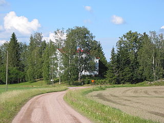
Kreivilä is a village in Myrskylä municipality in Eastern Uusimaa. It is located in the southeast part of the municipality, along the road from Myrskylä to Liljendal and Loviisa. The Lahti–Loviisa railway is located to the east of the village.

Teisko is a village and former municipality in Pirkanmaa region, Finland. It was consolidated in 1972 with Tampere, and at the same time Tampere got new districts: Kämmenniemi, Polso, Terälahti and Velaatta. Teisko's neighboring municipalities were Kangasala, Kuru, Orivesi, Ruovesi, Aitolahti and Ylöjärvi. Initially, the municipality comprised areas on both sides of Lake Näsijärvi, but in 1954, the areas west of Lake Näsijärvi were connected to Ylöjärvi and Kuru.

Aitolahti is a former municipality in Pirkanmaa region, Finland. It was consolidated in 1966 with Tampere, and at the same time Tampere got new districts: Sorila, Nurmi and Aitoniemi. Until 1947, the neighboring municipalities of Aitolahti included Messukylä, which was consolidated with the city of Tampere. Highway 9 (E63) between Tampere and Jyväskylä and the regional road 338 between Tampere and Ruovesi pass through Aitolahti.
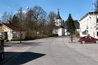
Lapinjärven kirkonkylä is the largest village and administrative center of the Lapinjärvi municipality, located on the eastern shore of Lake Lapinjärvi in Uusimaa, Finland. The distance from the village to the southern town of Loviisa is 23 kilometres (14 mi). The main road connection from the church village to Helsinki or Kouvola is Highway 6, along which the village is located.
