Mystic Valley Parkway station

Last updated
Mystic Valley Parkway
Proposed Mystic Valley Parkway station site (1), March 2022.JPG
The proposed station site in March 2022
General information
Location Mystic Valley Parkway (Route 16)
Somerville, Massachusetts
Coordinates 42°25′0.85″N71°7′39.11″W / 42.4169028°N 71.1275306°W / 42.4169028; -71.1275306
Line(s) Medford Branch
Platforms1 island platform (Green Line)
Tracks2 (Green Line)
2 (Lowell Line)
Proposed services
Preceding station MBTA.svg MBTA Following station
Terminus Green Line Medford/​Tufts
toward Heath Street
Former services at Medford Hillside
Preceding station Boston and Maine Railroad Following station
West Medford
toward Concord, NH
Boston – Concord, NH Tufts College
toward Boston

Mystic Valley Parkway station (also called Route 16 station) is a proposed light rail station on the MBTA Green Line in Somerville, Massachusetts; it would be built as part of a future third phase of the Green Line Extension (GLX). Route 16 would consist of one island platform, which would serve the E branch's two tracks.

Contents

History

Railroad station

Medford Steps station prior to 1875 First Medford Hillside station from Medford Historical Register.jpg
Medford Steps station prior to 1875

The Boston and Lowell Railroad opened through Somerville and Medford in 1835. It crossed the Middlesex Canal south of West Medford; the canal failed after the railroad's completion and it was filled in the 1850s. [1] [2] The original wooden bridge over the Mystic River at West Medford was replaced in 1852 with a stone arch bridge, which was later encased in concrete. [3] A reinforced concrete arch bridge of similar style was built just to the south in 1907–08 during construction of the Mystic Valley Parkway. Completed at a cost of $30,000 (equivalent to $690,000in 2022), it is 136 feet (41 m) long and 34 feet (10 m) wide, carrying the tracks 30 feet (9.1 m) above the parkway. [4] [5] [6]

Local passenger stops were gradually added on the line. Medford Steps station at South Street (now Winthrop Street) was a stop for Woburn Branch local trains by 1846. [7] [8] The first waiting room was the front room of an existing house. It was named for the lengthy set of steps to reach the tracks from Walnut Hill. [2] [3] A new station building was built on the southwest side of the tracks around 1875. [3] [9] The railroad planned to call it Walnut Hill, but yielded to local requests for the name Medford Hillside. "Walnut Hill" signs already made for the station were reused for a flag stop in Woburn. [3] The name was changed to Medford Hillside around August 27, 1876; three other stations on the line were also renamed. [10]

Frederick Stark Pearson became station agent in 1877 at age 16 after the death of his father, an engineer who had worked on the railroad. He served as agent until around 1880; he took classes at Tufts College the latter two years, with special permission from college president Elmer Hewitt Capen to leave classes to sell tickets. [11] [12] The former station building was moved to Auburn Street in West Medford around 1892, then moved again to nearby Cotting Street due to construction of the Mystic Valley Parkway. [3] [13]

The Winthrop Street bridge adjacent to the station was rebuilt in 1920 as part of a street widening project. [14] The station building, as well as wooden sidewalks on the bridge, was damaged by a fire on September 21, 1946. [15] Located in a cut at the bottom of College Hill, the tracks at the station were blocked by debris during heavy storms on several occasions. Rocks and dirt washed onto the tracks by rains from Hurricane Diane caused a Budd RDC to derail at the station on August 18, 1955. [16] [17]

On April 18, 1958, the Public Utilities Commission approved a vast set of cuts to Boston and Maine Railroad commuter service, including the closure of North Somerville, Tufts College, and Medford Hillside stations. [18] The three stations were closed on May 18, 1958, amid the first of a series of cuts. [19] [20] The former station building is no longer extant. [21]

Green Line station

The planned Green Line station was dropped from the list of stations that will open in 2022, in favor of the E branch terminating at Medford/Tufts station at College Avenue. The state successfully argued that this satisfied their legal commitment to mitigate the air pollution impact of the Big Dig by (among other projects) extending the Green Line to Medford Hillside.

In 2011, the Boston MPO decided to allocate funding in the 2016-2020 time period for further extension of the Green Line from College Ave to Route 16. [22] However, this funding was reallocated to the main project after major cost overruns created a budget crisis. A Route 16 station is still in the state's plans, with environmental review proceeding, as of 2017. [23]

In 2017, the MBTA filed a Notice of Project Change for a state environmental review of its revised design for a Green Line station at Mystic Valley Parkway (Route 16). While a station at this location was included in the original environmental review for the Green Line extension, the MBTA came up with a lower cost design that has the station at ground level. The previous design had a two-story station with a platform on the level of the adjacent commuter rail tracks, which are elevated to cross the Mystic River. The new station would include enclosed bicycle parking, but no automobile parking. [24]

Related Research Articles

<span class="mw-page-title-main">Alewife station</span> Rapid transit station in Cambridge, Massachusetts, US

Alewife station is a Massachusetts Bay Transportation Authority (MBTA) intermodal transit station in the North Cambridge neighborhood of Cambridge, Massachusetts. It is the northwest terminal of the rapid transit Red Line and a hub for several MBTA bus routes. The station is at the confluence of the Minuteman Bikeway, Alewife Linear Park, Fitchburg Cutoff Path, and Alewife Greenway off Alewife Brook Parkway adjacent to Massachusetts Route 2, with a five-story parking garage for park and ride use. The station has three bike cages. Alewife station is named after nearby Alewife Brook Parkway and Alewife Brook, themselves named after the alewife fish.

<span class="mw-page-title-main">Porter station</span> Transit station in Cambridge, Massachusetts, US

Porter station is a Massachusetts Bay Transportation Authority (MBTA) transit station in Cambridge, Massachusetts. It serves the Red Line rapid transit line, the MBTA Commuter Rail Fitchburg Line, and several MBTA bus lines. Located at Porter Square at the intersection of Massachusetts and Somerville Avenues, the station provides rapid transit access to northern Cambridge and the western portions of Somerville. Porter is 14 minutes from Park Street on the Red Line, and about 10 minutes from North Station on commuter rail trains. Several local MBTA bus routes also stop at the station.

<span class="mw-page-title-main">Wellington station (MBTA)</span> Rapid transit station in Medford, Massachusetts, US

Wellington station is a Massachusetts Bay Transportation Authority (MBTA) Orange Line rapid transit station in Medford, Massachusetts, near the border of Everett. It is located on the Revere Beach Parkway, slightly east of its intersection with Route 28. Wellington functions as a park and ride with more than 1,300 spaces, and a bus hub with 10 routes terminating at the station. The Station Landing development, connected to the station by an overhead walkway, includes residential and retail buildings and additional parking. Wellington Carhouse, the primary repair and maintenance facility for the Orange Line, is located adjacent to the station.

<span class="mw-page-title-main">Boston and Lowell Railroad</span> Former railroad in Massachusetts, United States

The Boston and Lowell Railroad was a railroad that operated in Massachusetts in the United States. It was one of the first railroads in North America and the first major one in the state. The line later operated as part of the Boston and Maine Railroad's Southern Division.

<span class="mw-page-title-main">Lechmere station</span> Light rail station in Cambridge, Massachusetts, US

Lechmere station is a Massachusetts Bay Transportation Authority (MBTA) Green Line light rail station in Lechmere Square in East Cambridge, Massachusetts. It is located on the east side of Monsignor O'Brien Highway near First Street, adjacent to the NorthPoint development. The accessible elevated station has a single island platform, with headhouses at both ends. It opened on March 21, 2022, as part of the Green Line Extension (GLX). Lechmere station is served by Green Line D branch and E branch service.

<span class="mw-page-title-main">Malden Center station</span> Transit station in Malden, Massachusetts, US

Malden Center station is a Massachusetts Bay Transportation Authority (MBTA) intermodal transit station in Malden, Massachusetts. Located on an elevated grade above Pleasant Street in downtown Malden, it serves the rapid transit Orange Line and the MBTA Commuter Rail Haverhill Line. The station has one island platform for the two Orange Line tracks and a single side platform for the single commuter rail track. Two busways are used by 13 MBTA bus routes.

<span class="mw-page-title-main">Lowell Line</span> MBTA Commuter Rail line

The Lowell Line is a railroad line of the MBTA Commuter Rail system, running north from Boston to Lowell, Massachusetts. Originally built as the New Hampshire Main Line of the Boston & Lowell Railroad and later operated as part of the Boston & Maine Railroad's Southern Division, the line was one of the first railroads in North America and the first major one in Massachusetts.

<span class="mw-page-title-main">Sullivan Square station</span> Rapid transit station in Boston, Massachusetts, US

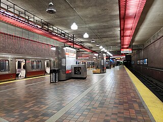
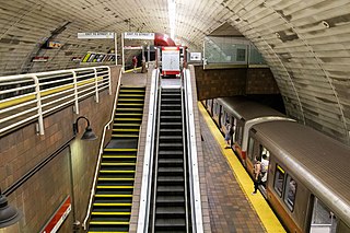
Sullivan Square station is a rapid transit station on the MBTA subway Orange Line, located adjacent to Sullivan Square in the Charlestown neighborhood of Boston, Massachusetts. It is a major transfer point for MBTA bus service, with 13 routes using a two-level busway. The station has two island platforms serving the two active Orange Line tracks plus an unused third track. The Haverhill Line and Newburyport/Rockport Line pass through the station on separate tracks but do not stop.

<span class="mw-page-title-main">Fitchburg Cutoff</span> Former rail line in Massachusetts, US

The Fitchburg Cutoff was a rail line running 2.8 miles (4.5 km) from Brighton Street in Belmont, Massachusetts, to Somerville Junction in Somerville, Massachusetts. It was constructed in two segments in 1870 and 1881 to connect the Lexington Branch and Central Massachusetts Railroad to the Boston and Lowell Railroad. Passenger service lasted until 1927. Freight service ended in 1979–80 to allow construction of the Red Line Northwest Extension; the line was abandoned in three sections in 1979, 1983, and 2007.

<span class="mw-page-title-main">Alewife Brook Parkway</span>

Alewife Brook Parkway is a short parkway in Cambridge and Somerville, Massachusetts. It is listed on the National Register of Historic Places. It begins at Fresh Pond in Cambridge, and heads north on the east bank of Alewife Brook, crossing into West Somerville and ending at the Mystic River on the Medford town line, where it becomes Mystic Valley Parkway. The entire length of Alewife Brook Parkway is designated as part of Massachusetts Route 16 (Route 16), while the southernmost sections are also designated as part of Route 2 and U.S. Route 3 (US 3). It is managed by the Department of Conservation and Recreation with the Massachusetts Department of Transportation responsible for bridge maintenance.

The Haymarket North Extension is a section of the Massachusetts Bay Transportation Authority's rapid transit Orange Line which currently constitutes the northern section of the line. It runs from North Station through an underground crossing of the Charles River, then along the Haverhill Line right-of-way to Oak Grove station in Malden, Massachusetts. Built to replace the Charlestown Elevated and originally intended to be extended as far as Reading, it opened in stages between 1975 and 1977.

<span class="mw-page-title-main">Mishawum station</span> Commuter rail station in Woburn, Massachusetts

Mishawum station is an MBTA Commuter Rail Lowell Line station located in the north part of Woburn, Massachusetts just north of the Route 128/I-95 beltway. The station has two side platforms serving the line's two tracks. Mishawum is a limited-service flag stop intended for reverse commuting to the adjacent office park, with no weekend service. With just 32 boardings on an average weekday in 2018, Mishawum is one of the least busy stations on the commuter rail system.

<span class="mw-page-title-main">Green Line Extension</span> Light rail system in greater Boston, US

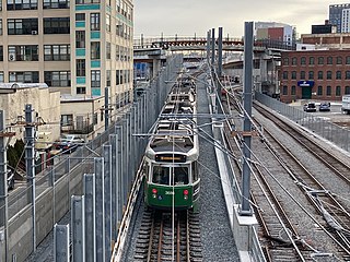
The Green Line Extension (GLX) was a construction project to extend the Massachusetts Bay Transportation Authority (MBTA) Green Line light rail system northwest into Somerville and Medford, two inner suburbs of Boston, Massachusetts. The project opened in two phases in 2022 at a total cost of $2.28 billion. Total ridership on the 4.3-mile (6.9 km) extension is estimated to reach 45,000 one-way trips per day in 2030.

<span class="mw-page-title-main">Sullivan Square</span>

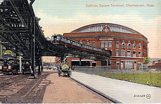
Sullivan Square is a traffic circle located at the north end of the Charlestown neighborhood of Boston, Massachusetts. It is named after James Sullivan, an early 19th-century Governor of Massachusetts. Sullivan Square station on the MBTA Orange Line is located just west of the square.

<span class="mw-page-title-main">Medford/Tufts station</span> Light rail station in Medford, Massachusetts, US

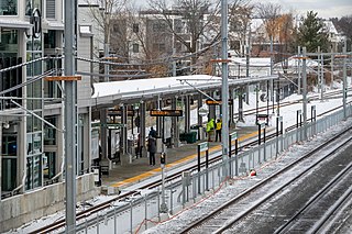
Medford/Tufts station is a light rail station on the Massachusetts Bay Transportation Authority (MBTA) Green Line located off Boston Avenue near College Avenue in Medford, Massachusetts, adjacent to Tufts University. The accessible station has a single island platform serving the two tracks of the Medford Branch. It opened on December 12, 2022, as part of the Green Line Extension (GLX), which added two northern branches to the Green Line, and is the northern terminus of the E branch.

<span class="mw-page-title-main">Ball Square station</span> Light rail station in Massachusetts, US

Ball Square station is a light rail station on the Massachusetts Bay Transportation Authority (MBTA) Green Line located at Ball Square in Somerville and Medford, Massachusetts. The accessible station has a single island platform serving the two tracks of the Medford Branch. It opened on December 12, 2022, as part of the Green Line Extension (GLX), which added two northern branches to the Green Line, and is served by the E branch.

<span class="mw-page-title-main">Magoun Square station</span> Light rail station in Somerville, Massachusetts, US

Magoun Square station is a light rail station on the Massachusetts Bay Transportation Authority (MBTA) Green Line located at Lowell Street south of Magoun Square in Somerville, Massachusetts. The accessible station has a single island platform serving the two tracks of the Medford Branch. It opened on December 12, 2022, as part of the Green Line Extension (GLX), which added two northern branches to the Green Line, and is served by the E branch.

<span class="mw-page-title-main">Gilman Square station</span> Light rail station in Somerville, Massachusetts, US

Gilman Square station is a light rail station on the Massachusetts Bay Transportation Authority (MBTA) Green Line located at Gilman Square in Somerville, Massachusetts. The accessible station has a single island platform serving the two tracks of the Medford Branch. It opened on December 12, 2022, as part of the Green Line Extension (GLX), which added two northern branches to the Green Line, and is served by the E branch.

<span class="mw-page-title-main">East Somerville station</span> Light rail station in Somerville, Massachusetts, US

East Somerville station is a light rail station on the Massachusetts Bay Transportation Authority (MBTA) Green Line located in southeastern Somerville, Massachusetts. The accessible station has a single island platform serving the two tracks of the Medford Branch. It opened on December 12, 2022, as part of the Green Line Extension (GLX), which added two northern branches to the Green Line, and is served by the E branch.

<span class="mw-page-title-main">Union Square station (Somerville)</span> Light rail station in Somerville, Massachusetts, US

Union Square station is a light rail station on the Massachusetts Bay Transportation Authority (MBTA) Green Line located in the Union Square neighborhood of southeastern Somerville, Massachusetts. The accessible terminal station has a single island platform serving the two tracks of the Union Square Branch, which parallels the Fitchburg Line. It opened on March 21, 2022, as part of the Green Line Extension (GLX), which added two northern branches to the Green Line.

References

  1. Draper, Martin Jr. (1852). "Map of Somerville, Mass". J.T. Powers & Co.
  2. 1 2 Kollner, Augustus (1855). "Map of the town of Medford, Middlesex County, Mass: surveyed by order of the town". H.F. Walling.
  3. 1 2 3 4 5 Dennison, Edward B. (March 1936). "Medford Railroad Stations: Notes and Reminiscences". The Medford Historical Register. Vol. 39, no. 1 via Internet Archive.
  4. "New Bridge at West Medford". Boston Globe. July 12, 1907. p. 14 via Newspapers.com.
  5. "Improvements in the Mystic Valley". Boston Globe. March 29, 1908. p. 60 via Newspapers.com.
  6. "Medford". Boston Globe. December 30, 1907. p. 3 via Newspapers.com.
  7. Knight, Ellen (2021). "The Evolution of Winchester's Four Railroad Depots". Town of Winchester.
  8. The Directory of the City of Boston. George Adams. 1850. p. 50 via Google Books.
  9. "Part of Medford". Atlas of Middlesex County, Massachusetts. Geo. H. Walker & Co. 1889. pp. 26–27 via Ward Maps.
  10. "Woburn/Middlesex Journal Newspaper Index, A-D" (PDF). Woburn Public Library. p. 65.
  11. Eliot, Samuel Atkins (1909). Biographical History of Massachusetts: Biographies and Autobiographies of the Leading Men in the State. Vol. 1. Massachusetts Biographical Society via Google Books.
  12. "Memoir of Fred Stark Pearson". Transactions of the American Society of Civil Engineers. Vol. 87. merican Society of Civil Engineers. 1924. p. 1402 via Google books.
  13. "Medford Hillside". Medford Historical Society Papers. Vol. 20. 1917.
  14. "Medford". Boston Globe. May 12, 1920. p. 6 via Newspapers.com.
  15. "3-Alarm Fire Strikes B. & M. Station, Bridge at Medford Hillside". Boston Globe. September 22, 1946. pp. 1, 28 via Newspapers.com.
  16. "Quick Work of Two Men Prevents Train Wreck". Boston Globe. June 20, 1922. p. 6 via Newspapers.com.
  17. "Commuters Hit Hard as Rains K.O. Road and Rail Traffic". Boston Globe. August 19, 1955. p. 13 via Newspapers.com.
  18. "Drastic Service Cuts Approved on Five B.& M. Divisions". Daily Boston Globe. April 19, 1958. p. 11 via Newspapers.com. Open Access logo PLoS transparent.svg
  19. Humphrey, Thomas J.; Clark, Norton D. (1985). Boston's Commuter Rail: The First 150 Years. Boston Street Railway Association. p. 57. ISBN   9780685412947.
  20. "B.&M. Closes Saugus Branch, 3 Other Lines". Daily Boston Globe. May 17, 1958. p. 3 via Newspapers.com. Open Access logo PLoS transparent.svg
  21. Roy, John H. Jr. (2007). A Field Guide to Southern New England Railroad Depots and Freight Houses. Branch Line Press. p. 117. ISBN   9780942147087.
  22. "Green Line Route 16 funding preserved!". Somerville Transportation Equity Partnership. 3 June 2011. Retrieved 26 July 2015.
  23. Op-Ed: Build The Green Line Extension To Rt. 16
  24. Notice of Project Change, Green Line Extension to Mystic Valley Parkway, MBTA, October 2017