
Luna County is a county located in the U.S. state of New Mexico. As of the 2010 census, the population was 25,095. Its county seat is Deming. This county abuts the Mexican border. Luna County comprises the Deming, NM Micropolitan Statistical Area.

Galkayo is the capital of the north-central Mudug region of Somalia. The city of Galkayo is divided into two administrative areas separated by a loose boundary.
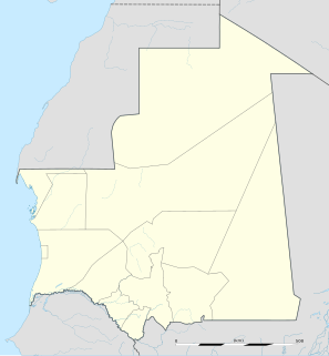
Tidjikja is the capital of the Tagant region of central Mauritania, lying on the Tagant plateau. Founded in 1680, it has a population of around 11,000 people.
The 14 nm process refers to the MOSFET technology node that is the successor to the 22 nm node. The 14 nm was so named by the International Technology Roadmap for Semiconductors (ITRS). Until about 2011, the node following 22 nm was expected to be 16 nm. All 14 nm nodes use FinFET technology, a type of multi-gate MOSFET technology that is a non-planar evolution of planar silicon CMOS technology.

Bobangui is a large M'Baka village in Lobaye, Central African Republic, located at the edge of the equatorial forest some 80 kilometres (50 mi) southwest of the capital, Bangui. The first Prime Minister of the Central African Republic, Barthélemy Boganda, the first President of the Central African Republic, David Dacko, and the emperor of the Central African Empire, Jean-Bédel Bokassa, were from Bobanqui.

Tiyo is a coastal town in east-central Eritrea, the capital of the Are'eta district in the Southern Red Sea region. Nearby towns and villages include Anrata (0.6 nm), Ad Gaban (6.3 nm), Sahli (8.0 nm), Babaiu (15.4 nm) and Faraon (17.9 nm).
Gbokopeteme is a village in the Lobaye region in the Central African Republic approximately 75 kilometres (47 mi) southwest of the capital, Bangui.
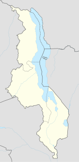
Mkangawi is a village in central Malawi 4.9 miles north-west of Chipoka. It is located in Salima District in the Central Region.
Ndimbi is a village in the Lobaye region in the Central African Republic southwest of the capital, Bangui.
Bamango is a village in the Lobaye region in the Central African Republic southwest of the capital, Bangui.
Benesa is a village in the Ouham region in the Central African Republic.
Banguele is a village in the Lobaye region in the Central African Republic southwest of the capital, Bangui.
Bohomandji is a village in the Lobaye region in the Central African Republic southwest of the capital, Bangui and near the border with the Democratic Republic of the Congo.
Mbokassa is a village in Mbaïki district in the Lobaye region in the Central African Republic southwest of the capital, Bangui.
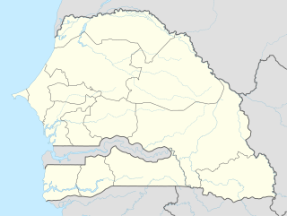
Gama is a small town in western-central Senegal. It is located in the Kaolack Region.

Akyauk is a village in Chipwi Township in Myitkyina District in the Kachin State of north-eastern Burma.

Saponé is a town in the Saponé Department of Bazèga Province in central Burkina Faso. The town has a population of 21,148 and is the capital of Saponé Department and is located approximately 40 kilometres south of Ouagadougou.
Zangogho is a town in the Toece Department of Bazèga Province in central Burkina Faso. The town has a population of 1,188.

Jagan is a village in Rezvan Rural District, Jebalbarez District, Jiroft County, Kerman Province, Iran. At the 2006 census, its population was 55, in 10 families.
Tagundaing or Ta Khun Taing is a large village in the Kayin State of south-eastern Myanmar, located near the west bank of the Winyaw River and the west of the Kyain Seikgyi Township, Kawkareik District.The population as of the 2014 census was 4,994. Most of the residents are of the Karen (Kayin) ethnic group.
This page is based on this
Wikipedia article Text is available under the
CC BY-SA 4.0 license; additional terms may apply.
Images, videos and audio are available under their respective licenses.
