Mörlunda

Last updated
Mörlunda
Sweden Kalmar location map.svg
Red pog.svg
Mörlunda
Sweden location map.svg
Red pog.svg
Mörlunda
Coordinates: 57°19′N15°51′E / 57.317°N 15.850°E / 57.317; 15.850 Coordinates: 57°19′N15°51′E / 57.317°N 15.850°E / 57.317; 15.850
Country Sweden
Province Småland
County Kalmar County
Municipality Hultsfred Municipality
Area [1]
  Total 2.19 km2 (0.85 sq mi)
Population (31 December 2010) [1]
  Total 838
  Density 382/km2 (990/sq mi)
Time zone CET (UTC+1)
  Summer (DST) CEST (UTC+2)
Morlunda church and surrounding farmland Morlunda kyrka....JPG
Mörlunda church and surrounding farmland
Morlunda church and surrounding farmland Morlunda kyrka 8.JPG
Mörlunda church and surrounding farmland

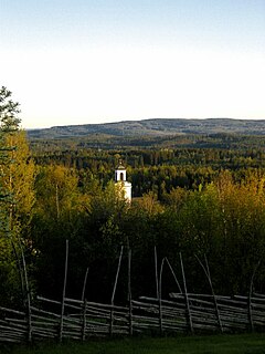
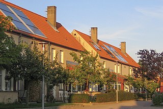
Mörlunda is a locality situated in Hultsfred Municipality, Kalmar County, Sweden with 838 inhabitants in 2010. [1]

Hultsfred Municipality Municipality in Kalmar County, Sweden

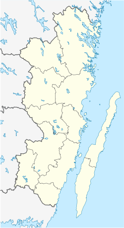
Hultsfred Municipality is a municipality in Kalmar County, in south-eastern Sweden. The seat is in the town of Hultsfred.

Kalmar County County (län) of Sweden

Kalmar County is a county or län in southern Sweden. It borders the counties of Kronoberg, Jönköping, Blekinge and Östergötland. To the east in the Baltic Sea is the island Gotland.

Sweden constitutional monarchy in Northern Europe

Sweden, officially the Kingdom of Sweden, is a Scandinavian Nordic country in Northern Europe. It borders Norway to the west and north and Finland to the east, and is connected to Denmark in the southwest by a bridge-tunnel across the Öresund, a strait at the Swedish-Danish border. At 450,295 square kilometres (173,860 sq mi), Sweden is the largest country in Northern Europe, the third-largest country in the European Union and the fifth largest country in Europe by area. Sweden has a total population of 10.2 million of which 2.5 million has a foreign background. It has a low population density of 22 inhabitants per square kilometre (57/sq mi). The highest concentration is in the southern half of the country.

It gave its name to a community in Greenbrier County, West Virginia. The name means "wooded marsh", a fitting description for its surroundings.

Morlunda, West Virginia Unincorporated community in West Virginia, United States

Morlunda is an unincorporated community in Greenbrier County, West Virginia, United States. Morlunda is 3.5 miles (5.6 km) northwest of Lewisburg.

Greenbrier County, West Virginia County in the United States

Greenbrier County is a county in the U.S. state of West Virginia. As of the 2010 census, the population was 35,480. Its county seat is Lewisburg. The county was formed in 1778 from Botetourt and Montgomery counties in Virginia.

West Virginia State of the United States of America

West Virginia is a state located in the Appalachian region in the Southern United States that is also considered to be a part of the Middle Atlantic States. It is bordered by Pennsylvania to the north, Maryland to the east and northeast, Virginia to the southeast, Kentucky to the southwest, and Ohio to the northwest. West Virginia is the 41st largest state by area, and is ranked 38th in population. The capital and largest city is Charleston.

Related Research Articles

Drottningholm Place in Uppland, Sweden

Drottningholm, literally "Queen's Islet", is a locality situated in Ekerö Municipality, Stockholm County, Sweden, with 398 inhabitants in 2010.

Mariefred Place in Södermanland, Sweden

Mariefred is a locality situated in Strängnäs Municipality, Södermanland County, Sweden with 3,726 inhabitants in 2010.

Landvetter Place in Västergötland, Sweden

Landvetter is a locality situated in Härryda Municipality, Västra Götaland County, Sweden. It had 7,152 inhabitants in 2010.

Gustavsberg, Värmdö Municipality Place in Uppland, Sweden

Gustavsberg is a locality situated on the island of Värmdö in Sweden's Stockholm archipelago. From an administrative perspective, it is in Stockholm County and is the seat of Värmdö Municipality. It has 11,333 inhabitants as of 2010. It is most known for its porcelain factory, Gustavsberg porcelain, and toilet bowls distributed nationwide and internationally.

Bankekind Place in Östergötland, Sweden

Bankekind is a locality situated in Linköping Municipality, Östergötland County, Sweden with 405 inhabitants in 2010. Bankekind was earlier called Svinstad but changed its name because of the pejorative connotations. It is known for its 13th-century church and the beautiful lake Svinstadsjön.

Rättvik Place in Dalarna, Sweden

Rättvik is a locality and the seat of Rättvik Municipality, Dalarna County, Sweden, with 4,686 inhabitants in 2010. Its bandy club IFK Rättvik wants to reach the highest division Elitserien and has built an indoor arena. The local baseball team, Rättvik Butchers has won the Swedish cup once and the Swedish championship twice.

Pajala Place in Norrbotten

Pajala is a locality and the seat of Pajala Municipality in Norrbotten County, Sweden, with 1,958 inhabitants in 2010.

Åsele Place in Lapland, Sweden

Åsele is a locality and the seat of Åsele Municipality in Västerbotten County, province of Lapland, Sweden with 1,798 inhabitants in 2010. Its elevation is 313 m (1027 ft).

Jukkasjärvi Place in Lapland, Sweden

Jukkasjärvi is a locality situated in Kiruna Municipality, Norrbotten County, Sweden with 548 inhabitants in 2010. It is situated at 321 meters elevation.

Trollhättan Place in Västergötland, Sweden

Trollhättan is a city and the seat of Trollhättan Municipality, Västra Götaland County, Sweden, with 46,457 inhabitants in 2010. It is located 75 km north of Sweden's second-largest city, Gothenburg.

Mariestad Place in Västergötland, Sweden

Mariestad is a locality and the seat of Mariestad Municipality, Västra Götaland County, Sweden. It had 15,591 inhabitants in 2010. It was until 1997 the capital of the former Skaraborg County and an episcopal see in the Church of Sweden between 1583 and 1646.

Katrineholm Place in Södermanland, Sweden

Katrineholm is a locality and the seat of Katrineholm Municipality, Södermanland County, Sweden with 21,993 inhabitants in 2010. It is located in the inland of Södermanland and is the third largest urban area in the county after Eskilstuna and county seat Nyköping.

Kristinehamn Place in Värmland, Sweden

Kristinehamn is a locality and the seat of Kristinehamn Municipality, Värmland County, Sweden, with 17,839 inhabitants in 2010.

Bjursås Place in Dalarna, Sweden

Bjursås[ˈbjʉː̠ˈʃɔs] is a locality situated in Falun Municipality, Dalarna County, Sweden with 1,839 inhabitants in 2010.

Lagan, Sweden Place in Småland, Sweden

Lagan is the second largest locality situated in Ljungby Municipality, Kronoberg County, Sweden, with 1,744 inhabitants in 2010. It is at an altitude of 139 meters (459 feet). It has got its name from the river Lagan, which passes nearby.

Rosersberg Place in Uppland, Sweden

Rosersberg is a locality situated in Sigtuna Municipality, Stockholm County, Sweden with 1,671 inhabitants in 2010.

Tygelsjö Place in Skåne, Sweden

Tygelsjö is a locality situated in Malmö Municipality, Skåne County, Sweden with 2,710 inhabitants in 2010.

Koskullskulle Place in Lapland, Sweden

Koskullskulle is a locality situated in Gällivare Municipality, Norrbotten County, Sweden with 874 inhabitants in 2010.

Skumparp Neighbourhood in Skåne County, Skåne, Sweden

Skumparp is a neighbourhood of Malmö, situated in the Borough of Limhamn-Bunkeflo, Malmö Municipality, Skåne County, Sweden. It is also a locality and had 205 inhabitants in 2010.

Toarp, Malmö Neighbourhood in Skåne County, Skåne, Sweden

Toarp is a neighbourhood of the Borough of Oxie, Malmö Municipality, Skåne County, Sweden. It is also a locality and had 219 inhabitants in 2010.

References

  1. 1 2 3 "Tätorternas landareal, folkmängd och invånare per km2 2005 och 2010" (in Swedish). Statistics Sweden. 14 December 2011. Archived from the original on 10 January 2012. Retrieved 10 January 2012.