
Młynów (Polish pronunciation: [ˈmwɨnuf] ) is a neighbourhood of the western borough of Wola in Warsaw, the capital of Poland.
Młynów (Polish pronunciation: [ˈmwɨnuf] ) is a neighbourhood of the western borough of Wola in Warsaw, the capital of Poland.
Since late Middle Ages the area of modern Młynów belonged to the nearby village of Wielka Wola. Initially mostly occupied by arable land, in 1792 the Evangelical Cemetery of the Augsburg Confession was founded there. Soon afterwards additional cemeteries were built nearby: Christian Powązki Cemetery and the Okopowa Street Jewish Cemetery (both in modern times located in the neighbourhood of Powązki). In the 19th century the rapidly growing city swallowed Wola and its fields, located right outside the city limits were a convenient location for numerous windmills, which became the namesake for the entire area: Młynów's literal translation is "Place of Mills". Opening of the Warsaw–Vienna railway saw many granaries constructed there as well. During World War I, in 1916 Młynów, along with the rest of the suburb of Wola, was incorporated into the city of Warsaw. During the following war and the Warsaw Uprising of 1944 most of the original cityscape has been levelled to the ground by the Germans. After the war the neighbourhood was rebuilt, in part in Soc-Realist style.

Powązki Cemetery, also known as Stare Powązki, is a historic necropolis located in Wola district, in the western part of Warsaw, Poland. It is the most famous cemetery in the city and one of the oldest, having been established in 1790. It is the burial place of many illustrious individuals from Polish history. Some are interred along the "Avenue of the Distinguished" – Aleja Zasłużonych, created in 1925. It is estimated that over one million people are buried at Powązki.

The Monuments to the Warsaw Uprising were first established in Warsaw in the 1970s. Prior to that, there were only monuments to the Red Army soldiers and the Armia Ludowa soldiers. The role of the latter in the city fights in 1944 was exaggerated and overrated. Most of the victims of the Uprising who were buried in graves all over the city were later exhumed and buried in mass graves far away from the city centre, with a small concrete monument to "the victims of the war with Nazism". No mention of the Uprising was allowed.
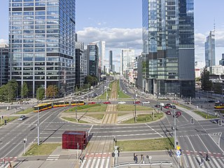
Wola is a district in western Warsaw, Poland. An industrial area with traditions reaching back to the early 19th century, it underwent a transformation into a major financial district, featuring various landmarks and some of the tallest office buildings in the city.

Jewish cemeteries of Warsaw refers to a number of Jewish necropolises in the city.

The Warsaw Jewish Cemetery is one of the largest Jewish cemeteries in Europe and in the world. Located on Warsaw's Okopowa Street and abutting the Christian Powązki Cemetery, the Jewish necropolis was established in 1806 and occupies 33 hectares of land. The cemetery contains over 250,000 marked graves, as well as mass graves of victims of the Warsaw Ghetto. Although the cemetery was closed down during World War II, after the war it was reopened and a small portion of it remains active, serving Warsaw's existing Jewish population.

Jerusalem Avenue is one of the principal streets of the capital city of Warsaw in Poland. It runs through the City Centre along the East-West axis, linking the western borough of Wola with the bridge on the Vistula River and the borough of Praga on the other side of the river.

The Wola massacre was the systematic killing of between 40,000 and 50,000 Poles in the Wola neighbourhood of the Polish capital city, Warsaw, by the German Waffen-SS and fellow Axis collaborators in the Azerbaijani Legion, as well as the predominantly-Russian RONA forces, which took place from 5 to 12 August 1944. The massacre was ordered by Heinrich Himmler, who directed to kill "anything that moves" to stop the Warsaw Uprising soon after it began.

Wesoła is one of the districts of Warsaw, and has been as such since October 27, 2002. Wesoła is located in the south-eastern part of city.

Muranów is a neighbourhood in the districts of Śródmieście (Downtown) and Wola in central Warsaw, the capital of Poland. It was founded in the 17th century. The name is derived from the palace belonging to Simone Giuseppe Belotti, a Venetian architect, who originally came to Warsaw from the island of Murano. It is the northernmost neighbourhood of the downtown area.
Boernerowo is a neighbourhood in the Warsaw's borough of Bemowo. Initially the spot was occupied by a small village called Babice, with an eponymous fort located in its centre. In early 1920s the area surrounding the fort was bought by the Polish state and in 1922 the Ministry of Post and Telegraphs started the construction of the Transatlantic Radio Station. As the radio station did not occupy the entire terrain, in 1932 minister Ignacy Boerner ordered a construction of a housing area to accommodate the workers of the radio station, as well as other people working in communications industry in the nearby city of Warsaw. The settlement grew and in 1936 it was named after its founder.

Czysta is one of the neighborhoods of the Wola district of Warsaw, Poland. It is limited by Wolska and Towarowa streets from the north and east and by railway lines from the west and south.

The Warsaw Insurgents Cemetery is located at 174/176 Wolska Street in the Wola district of Warsaw. It was established in 1945 and occupies 1.5 hectares.

Powązki Military Cemetery is an old military cemetery located in the Żoliborz district, western part of Warsaw, Poland. The cemetery is often confused with the older Powązki Cemetery, known colloquially as "Old Powązki". The Old Powązki cemetery is located to the south-east of the military cemetery.
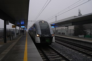
Warszawa Młynów railway station is a railway station in the Wola district of Warsaw, Poland. It was built on the Warsaw orbital line, which goes through Warszawa Gdańska station. In 2011, it was used exclusively by Koleje Mazowieckie which run the KM9 services from Warszawa Wola through the north of the Masovian Voivodeship to Działdowo, in the Warmian-Masurian Voivodeship, via Legionowo, Nasielsk, Modlin, Ciechanów and Mława, at all of which some trains terminate.

St. Lawrence's Church is a Roman Catholic church located in Warsaw's borough of Wola. A neoclassicist building, the site is best known as the central point of Polish "Redoubt No. 56" during the 1831 battle for Warsaw.

Wolska is the main artery of Warsaw's borough of Wola. Initially Wola district was but a western suburb of Warsaw and a road leading to it was dubbed "droga wolska" - Wola road. In 1725 parts of that road closest to the Warsaw Old Town, located along the Saxon Axis, were officially renamed to "Aleja Wolska" - Wola Avenue. In modern times it starts at a crossing of Chłodna and Towarowa Streets, and runs as a continuation of Solidarity Avenue through the neighbourhoods of Młynów, Czyste and Ulrychów, all the way to Połczyńska Street.

The Wola Massacre Memorial on Górczewska Street is a war memorial located at 32 Górczewska Street in the Wola district of Warsaw, Poland.

Ujazdów is a prominent neighbourhood situated in central Warsaw, the capital of Poland. It is the southernmost part of the Downtown (Śródmieście) district, next to Solec and historical Frascati. The main thoroughfare passing through the neighbourhood is Ujazdów Avenue; the Chancellery of the Prime Minister of Poland, the Foreign Ministry and the Belweder Palace are located on or in the vicinity of the street. Ujazdów is an affluent neighbourhood, with villas, palaces and parks comprising most of its area. The most notable landmarks are the Łazienki Park and Palace on the Isle, the 18th century summer residence of Poland's last monarch Stanisław II Augustus.

Odolany is a neighbourhood, and an area of the City Information System, in the city of Warsaw, Poland, located within the district of Wola.
52°14′21″N20°57′36″E / 52.2392°N 20.9601°E
| | This Warsaw-related article is a stub. You can help Wikipedia by expanding it. |