Kankan (Mandingo: Kánkàn) is the largest city in Guinea in land area, and the third largest in population, with a population of 193,830 people as of 2014. The city is located on the Milo River in eastern Guinea and lying about 345 miles east of Conakry.

Dalaba is a town and sub-prefecture in the Dalaba Prefecture in the Mamou Region of Guinea.

Boké is the capital city of Boké Prefecture within the Boké Region of Lower Guinea near the border with Guinea-Bissau. It is also a sub-prefecture of Guinea. Located along the Rio Nuñez which flows to its not-too-distant mouth on the Atlantic Ocean, Boké is a port. It is known for the Fortin de Boké museum, formerly a slave fort. The town is served by Boké Baralande Airport. As of 2014 the city and surrounding sub-prefecture had a population of 61,449 people.

The Kankan Region is located in eastern Guinea. It is bordered by the countries of Mali and Côte d'Ivoire and the Guinean regions of Nzérékoré and Faranah.

The Boké Region is located in western Guinea. It is bordered by the countries of Senegal and Guinea-Bissau and the Guinean regions of Kindia and Labé. Its capital is the city of Boké.

Yomou is a prefecture located in the Nzérékoré Region of Guinea. The capital and principal town of the prefecture is Yomou. The prefecture covers an area of 3,920 km.² and has an estimated population of 114,371.

Koundara is a prefecture located in the Boké Region of Guinea. The capital is Koundara. The prefecture covers an area of 5,238 km.² and has a population of 130,205.

Kouroussa is a prefecture located in the Kankan Region of Guinea. The capital is Kouroussa. The prefecture covers an area of 14,050 km.² and has a population of 268,630. With Kouroussa town by far the largest in the Prefecture numbering only 10,000, the vast majority of the Prefecture's population live in small rural communities, making their living from subsistence and small scale cash crop agriculture, as well as small scale trade and mining. The majority of the population are members of the Malinke ethnic group or related Mande speakers. The eastern portion of the prefecture is formed from the Niger River valley, while most of the area characterized by low rolling hills and dry savanna grasslands or scrub-like forest.

The Labé Region is located in north-central Guinea. It is bordered by the countries of Senegal and Mali and the Guinean regions of Faranah, Kindia, Mamou, and Boké.
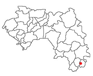
Nzo or N'Zoo is a town and sub-prefecture in the Lola Prefecture in the Nzérékoré Region of south-eastern Guinea.
Koulé is a town and sub-prefecture in the Nzérékoré Prefecture in the Nzérékoré Region of Guinea.
Beindou is a town and sub-prefecture in the Faranah Prefecture in the Faranah Region of Guinea. As of 2014 it had a population of 16,521 people.
Bolodou is a town and sub-prefecture in the Guéckédou Prefecture in the Nzérékoré Region of south-western Guinea. The sub-prefecture had a population of 13,643 people in 2014, up from 11,750 in 1996. The town itself holds 94 houses with an unknown total population. The Bolodou Sub-Prefecture is divided into 7 quarters (districts), which are: Beddou, Bolodou Centre, Faindou, Gbandou, Koleadou, Kongoma, and Soumtou. Each of these towns can further be split into sectors, which are the smallest administrative divisions in Guinea. In 2017, a local math teacher set up his own dam to generate hydroelectric power for the town's homes. In December 2017, a 27-meter long bridge was built that connected the previously separate markets in Yèndè Millimou and Guéckédou.
Diari, Guinea is a town and sub-prefecture in the Labé Prefecture in the Labé Region of northern-central Guinea.
Fougou, Guinea is a town and sub-prefecture in the Mali Prefecture in the Labé Region of northern Guinea.
Porédaka is a town and sub-prefecture in the Mamou Prefecture in the Mamou Region of Guinea. It is located roughly 55 kilometres (34 mi) northeast of Mamou. The Battle of Porédaka took place here on 13 November 1896, during which French colonial troops decisively defeated the last forces of the Imamate of Futa Jallon, after which Futa Jallon was annexed into Senegambia.
Koin, Guinea is a town and sub-prefecture in the Tougué Prefecture in the Labé Region of northern-central Guinea.
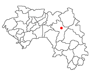
Kouroukoro is a town located in northwestern Guinea, and the capital is Kouroussa. It has an estimated population of a few thousands. The town and surrounding area is a center of Malinke culture. Kouroukoro is a district in upper Guinea, Republic of Guinea, West Africa. It is part of the Prefecture of Kouroussa and sous-prefecture of Cissela. Kouroukoro lies about 500 km from the capital Conakry, about 50 km from the prefecture of Dabola and about 95 km from the prefecture of Kouroussa