Sikar district is a district of the Indian state Rajasthan in northern India. The city Sikar is the administrative headquarters of the district. Sikar, Laxmangarh, and Fatehpur Shekahwati are the largest cities and tehsils of the district.

Fatehpur Chaurasi is a town and a nagar panchayat in Unnao district in the state of Uttar Pradesh, India. First officially classified as a town for the 1981 census, Fatehpur Chaurasi is located on the north bank of the Kalyani river, a bit to the south of the main road from Unnao to Bangarmau. Local industries include the production of furniture, boxes, almirahs, shoes, and slippers. As of 2011, the town's population is 6,715, in 1,158 households.
Rajiana is a village of Malwa region in District Moga, Punjab. The village is divided into pattis like Vigha patti, Narang ki patti, Haveli patti, Joga Patti, Ghoga Patti, Wazir patti, Rania Patti etc. The people of the village belongs to various religions, most of them are Jatt Sikhs of Brar clan. The village has three panchayats; Rajiana, Rajiana Patti Vigha and Rajiana Khurd. There are three water works and 3 water filters in the village supplying pure water to the villagers. There is a Co-operative bank, Revenue office, Corporate society for farmers, two petrol pumps, three Government schools, three private school, Government hospital, Government veterinary hospital, Multiplex and Hotel, two playgrounds, 5 mini parks, two marriage resorts, mobile towers and all other facilities.
Mundara is a village located in the Bali tehsil of Pali district of Rajasthan state, located on the Bali-Sadri Road (SH-16).
Bhoodha Ka Bas is a village in the Laxmangarh administrative region of the Sikar district of Indian state Rajasthan. Bhoodha Ka Bas village is separated from the Beerodi Bari village and situated in the north-east side of the Sikar district. Village is situated approximately 22 kilometres (14 mi) east of Laxmangarh town and 4 kilometres (2.5 mi) west of Nawalgarh town.
Kheri Shilla is a village in Makrana tehsil in Nagaur district, Rajasthan state of India. It is 7 km from Gachhipura. Other names for Kheri Shella are Mundelo Ki kheri and Guda Kheri, and the latest name of is Devnagari Kheri Sheela.
Jalimpura also known as Charna ki dhani is a village in Bhimsar gram panchayat, Mandawa, Tehsil, Jhunjhunu district, Rajasthan, India. All resident of the village belongs to Jaat community.
Manakawad is a village in Dharwad district of Karnataka, India.
Boraj Tawaran is a village in the Udaipur district of Rajasthan, India. It comes under the Malpur gram panchayat, in Salumber block. The village is located 8 km east of Salumber. It is also known as Boraj Tanwaran or Boraj Tavraan. Salumbar is nearest town to Boraj Tawaran village.Around 1700 CE, a Thakur of the Tanwar clan moved to Salumber during the rule of Rawat Kesari Singh Chundawat. In 1876, his descendant Thakur Tej Singh Tanwar was granted the jagir of the present-day village site to Rawat Jodh Singh Chundawat.
Mahtawas is a village in Neemrana tehsil, Alwar district, Rajasthan state, India. It is a part of the National Capital Region.
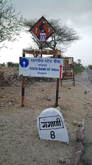
Gangani is a village situated in Baori Tehsil, Jodhpur (Rajasthan). Its geographical location coordinates are 26° 30' 3" North, 73° 12' 42" East.
Deengli is a village in Rajgarh, Churu, Rajasthan, India. As per 2011 Census of India, the village has population of 2197 of which 1144 are males while 1053 are females. It comes under ‘’’Sulkhnia chhotta’’’ Panchayath. It belongs to Bikaner Division. As per constitution of India and Panchyati Raaj Act, Deengli village is administrated by Sarpanch who is elected representative of village. It is located 65 km towards East from District headquarters Churu. 230 km from State capital Jaipur. The most famous place in Deengli is Net Dada JI temple.
Nanagwas is a small village located in Behror Tehsil of Alwar District, Rajasthan, India.

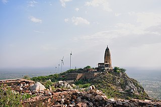
Vijaipura is a village in the Sikar district of Rajasthan, India. It is located on the Sikar-Salasar road, to the north of Sewad Bari, 21 kilometres (13 mi) from the city of Sikar and 126 kilometres (78 mi) from the state capital Jaipur.
Fatehpur is a village in fatehpur bhullowala of Punjab State, India. It is located 14 kilometres (8.7 mi) from Kapurthala, which is both district and sub-district headquarters of Fatehpur. The village is administrated by a Sarpanch, who is an elected representative.
Fatehpur is a village in Bhulath Tehsil in Kapurthala district of Punjab State, India. It is located 9 kilometres (5.6 mi) from Bhulath, 33 kilometres (21 mi) away from district headquarter Kapurthala. The village is administrated by a Sarpanch who is an elected representative of village as per the constitution of India and Panchayati raj (India).
Khan Khana or Khankhana is a village in Shaheed Bhagat Singh Nagar district of Punjab State, India. It is located 4 kilometres (2.5 mi) away Mukandpur, 7 kilometres (4.3 mi) from Banga, 13.5 kilometres (8.4 mi) from district headquarter Shaheed Bhagat Singh Nagar and 111 kilometres (69 mi) from state capital Chandigarh. The village is administrated by Sarpanch an elected representative of the village.
Khandrawali is a large village located in Kairana tehsil of Shamli district in the Indian state of Uttar Pradesh.
Hemal Kheri is a small village located in [8 km] Ramganj Mandi Tehsil of Kota, Rajasthan with a total of 117 families Living. The Hemal Kheri village has a population of 556 of which 295 are males and 261 are females as per Population Census 2011.

Deenshah Gaura is a community development block in Dalmau tehsil of Raebareli district, Uttar Pradesh, India. It consists of 71 rural villages, with a total population of 104,149 people. The headquarters are located in the village of Gaura Hardo.


