Nahal Zin

Last updated • 6 min readFrom Wikipedia, The Free Encyclopedia
Nahal Zin
PikiWiki Israel 47825 Geography of Israel.jpg
Location
State Israel
RegionNegev

Nahal Zin (in Hebrew:נחל צין Arabic: Wadi al-Fikra) is one of the largest intermittent streams in the Negev, and it is commonly seen as the border between the northern and central Negev. The stream flows from the Plain of the Winds north of the Ramon Crater, passes south and at the foot of the Ben-Gurion Institute, and continues from there. In the northern Arava, the stream is dammed by an earthen embankment, flows into the drainage systems of the Dead Sea Works, and is diverted to the northern basin of the Dead Sea. The length of the stream is about 120 kilometers, and it is the second largest intermittent stream in Israel after Nahal Paran. [1] [2]

Contents

MidreshetBenGurionMar262022 03.jpg

Nahal Zin has several names in Arabic, a different name for each section. The first, Wadi Nafha, flows from the high Negev mountain area to the point where the wadi turns 90 degrees east (after the Nabatean city of Avdat). The second part is called Wadi Mora after Ein Mora (the bitter spring named for its brackish waters), the lowest spring in the series of springs in the wadi's gorge (after Ein Ma'arif and Ein Avdat). The third part is Wadi Fukra, which flows from the canyon of Ein Avdat to the Dead Sea (the name means the poor stream, due to the scarcity of grazing food and the few acacia trees in the wadi). [2]

About 2 km north of the entrance to the Ein Avdat National Park, Nahal Zin forms a 'knee' where the stream turns at a right angle from north to east. The 'knee' was formed by ancient stream capture activity, where Nahal Zin captured the waters of an ancient and large stream that flowed before the formation of the Syrian-African Rift from the Edom Mountains westward to the Mediterranean Sea.

On average, about four flash floods occur annually in Nahal Zin. In 2004, a peak flow rate of 1,280 cubic meters per second was measured in the stream, the highest in Israel. In January 2010, this record was broken in Nahal Nitzana, where a flow rate of 1,420 cubic meters per second was measured. In 2007, part of the Nahal Zin channel and the erosion cliffs on both banks were declared a national park named "Sculpture Garden". [3]

The Biblical Zin River

MidreshetBenGurionMar262022 04.jpg

Among biblical commentators, there is a debate regarding the location of the biblical Zin River. One interpretation suggests that the Zin River was located in the area of Halutza, Shivta, and Nitzana, an area that constitutes the drainage basin of today's Zin River. There is confusion between the Zin River and the Sin River mentioned in the Book of Exodus as being "between Elim and Sinai."

IHM nKHl TSyn 3.jpeg

The Dam on Nahal Zin

Naturally, the stream flows with floodwaters on average four times a year. It crosses the Negev, descends to the Arava Valley, and there splits into a giant alluvial fan that for millions of years flowed into the Sodom Salt Flat. In recent decades, Nahal Zin ends at a wide earthen dam built by the Dead Sea Works to protect the evaporation ponds from floods. Instead of flowing into the salt flat, the stream is diverted into the plant's water drainage system and redirected to the Jordan River and Nahal Arava. As a result, and due to the agricultural activity of the two settlements in the Sodom Plain, the area of the salt flat has shrunk by about 90%.

Ecological Disaster in Nahal Tzin

Within the boundaries of Nahal Tzin runs the Eilat-Ashkelon pipeline, a 42-inch diameter, 254-kilometer-long oil pipeline. This line was used to transport jet fuel between the Mediterranean Sea and the Gulf of Eilat. After faults were discovered in the pipeline's casing and it did not meet the requirements of the Ministry of Environmental Protection, the flow in the pipeline was stopped, and the operating company began upgrading the line. In June 2011, during the upgrade works, a backhoe hit the fuel pipeline and caused a jet fuel leak in the nature reserve. According to estimates, over one and a half million liters of fuel flowed in the Nahal Tzin streambed. The fuel pollution in the nature reserve threatened important springs downstream, necessitating quick action to save the reserve. The terrain did not allow immediate access to the leak area. To minimize the damage, initial actions were taken such as: manually closing valves, closing the area to hikers, building a barrier downstream to stop the fuel flow, and digging storage pits to collect the liquid fuel. The ecological consequences of the leak were severe: plants dried up and died, animals relying on these plants were harmed, and there was a serious concern that the pollution would be carried into the groundwater and the oases downstream due to the rains and floods typical of the area. Inspectors testified that even months after the incident, the stream reeked of fuel, Maariv , 22/07/2011}}}}. The Magistrate's Court convicted the EAPC company and several former senior officials in the company of severe pollution of Nahal Tzin and its surroundings following two leak incidents, in September and June.

Stream rehabilitation

The geology of the stream dictated the method of pollution treatment, and experts decided that the required action was ex situ biological treatment, meaning excavation and removal of the soil to authorized sites where the treatment would be carried out. This strategy was chosen to prevent the persistence of the pollution and the leakage of organic pollutants into the groundwater. The excavation depth was limited to 5 meters or until the bedrock of the streambed, due to concerns about the collapse of the stream banks. The utmost importance was given to completing the excavations and covering the stream with material identical to that removed before the start of the rainy season.

The excavated soil was transferred, among other places, to the Afek site, which receives fuel-contaminated soils and reduces the contaminant concentration to a level where it can be reused as cover soil in landfills. The treatment was done using biological treatment with "oil-eating" bacteria that reduced the pollution level in an environmentally friendly way. The primary advantages of the treatment are the reduction of the volume of waste landfilled, the reduction of pollution levels, and the possibility of reusing the soil. About 65% of the leaked fuel was collected in excavation operations that lasted several months.

During this time, some of the fuel seeped to a depth of more than 5 meters and penetrated the gravel aquifer that feeds Ein Akrab and Ein Tzin downstream. In light of this, EAPC, following the Ministry of Environmental Protection's guidance, proposed a long-term monitoring plan for the streambed to assess the pollution potential and its spread. The leak incident and the treatment strategy sparked many controversies and discussions among environmental experts. [4]

See also

Related Research Articles

<span class="mw-page-title-main">Geography of Israel</span>

The geography of Israel is very diverse, with desert conditions in the south, and snow-capped mountains in the north. Israel is located at the eastern end of the Mediterranean Sea in West Asia. It is bounded to the north by Lebanon, the northeast by Syria, the east by Jordan and the West Bank, and to the southwest by Egypt. To the west of Israel is the Mediterranean Sea, which makes up the majority of Israel's 273 km (170 mi) coastline, and the Gaza Strip. Israel has a small coastline on the Red Sea in the south.

<span class="mw-page-title-main">Negev</span> Desert in southern Israel

The Negev or Negeb is a desert and semidesert region of southern Israel. The region's largest city and administrative capital is Beersheba, in the north. At its southern end is the Gulf of Aqaba and the resort city and port of Eilat. It contains several development towns, including Dimona, Arad, and Mitzpe Ramon, as well as a number of small Bedouin towns, including Rahat, Tel Sheva, and Lakiya. There are also several kibbutzim, including Revivim and Sde Boker; the latter became the home of Israel's first Prime Minister, David Ben-Gurion, after his retirement from politics.

<span class="mw-page-title-main">Arabah</span> Area south of the Dead Sea basin in Israel and Jordan

The Arabah/Araba or Aravah/Arava is a loosely defined geographic area in the Negev Desert, south of the Dead Sea basin, which forms part of the border between Israel to the west and Jordan to the east.

<span class="mw-page-title-main">Yarkon River</span> River in central Israel

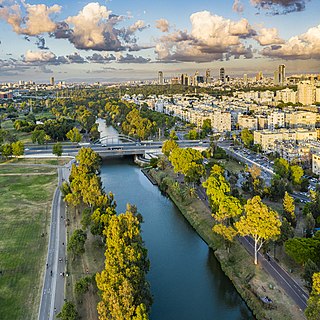
The Yarkon River, also Yarqon River or Jarkon River, is a river in central Israel. The source of the Yarkon is at Tel Afek (Antipatris), north of Petah Tikva. It flows west through Gush Dan and Tel Aviv's Yarkon Park into the Mediterranean Sea. Its Arabic name, al-Auja, means "the meandering". The Yarkon is the largest coastal river in Israel, at 27.5 km in length.

The Eilat Ashkelon Pipeline Company operates several crude petroleum and refined petroleum products pipelines in Israel, most notably the Eilat Ashkelon Pipeline – which transports crude oil across southern Israel, between the Red Sea and the Mediterranean Sea. The EAPC also operates two maritime oil terminals as well as oil storage depots in the country.

<span class="mw-page-title-main">Wadi Gaza and Besor Stream</span> Wadi in southern Israel and Palestine

Wadi Gaza and Besor Stream are parts of a river system in the Gaza Strip and Negev region of Palestine and Israel. Wadi Gaza is a wadi that divides the northern and southern ends of the Gaza Strip, its major tributary is Besor Steam. In 2022 work began to rehabilitate Wadi Gaza Nature Reserve.

<span class="mw-page-title-main">Ramat HaNegev Regional Council</span> Local government in Israel

Ramat HaNegev Regional Council is a regional council in the Negev desert in Israel. With around 8,000 residents spread across 20 villages, the council is geographically the largest in Israel, covering more than 20% of Israel's landmass. The council's headquarters are located on Highway 40 between Mashabei Sadeh and Tlalim.

<span class="mw-page-title-main">HaMakhtesh HaKatan</span>

HaMakhtesh HaKatan or simply Makhtesh HaKatan or Makhtesh Katan, is a makhtesh, a geological erosional landform, situated in Israel's Negev desert. At 5 km by 7 km, it is the third largest of the five makhteshim in the Negev, from a total of seven known major makhteshim, of which two are in Egypt's Sinai desert. It was charted in 1942 by Jewish explorers.

<span class="mw-page-title-main">Ein Avdat</span>

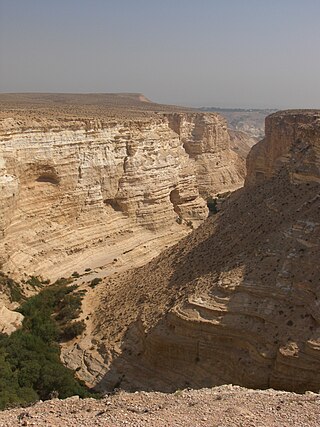
Ein Avdat or Ein Ovdat is a canyon in the Negev Desert of Israel, south of Kibbutz Sde Boker. Archaeological evidence shows that Ein Avdat was inhabited by Nabateans and Catholic monks. Numerous springs at the southern opening of the canyon empty into deep pools in a series of waterfalls. The water emerges from the rock layers with salt-tolerant plants like Poplar trees and Atriplexes growing nearby.

The Yellow River oil spill was an oil spill in the Yellow River in Shaanxi, China which took place due to the rupturing of a segment of Lanzhou-Zhengzhou oil pipeline on December 30, 2009. Approximately 150,000 L (40,000 US gal) of diesel oil flowed down the Wei River before finally reaching the Yellow River, the source of drinking water for millions of people, on January 4, 2010.

<span class="mw-page-title-main">Nahal Amud</span> River in Upper Galilee region of Israel

Nahal Amud, also known as the Wadi al-Amud, is a stream in the Upper Galilee region of Israel that flows into the Sea of Galilee.

<span class="mw-page-title-main">Nahal Tavor</span> Stream and nature reserve in Israel

Nahal Tavor, lit.Tabor Stream, is an intermittent stream in the Lower Galilee, Israel.

The Nahal Zin fuel leak was a severe ecological disaster caused in June 2011 when a backhoe loader struck and ruptured an underground fuel pipeline in southern Israel. 1.5 million liters of jet fuel leaked into the surrounding soil, resulting in localized soil contamination, damage to nearby flora, and wasted fuel. It is considered the worst ecological disaster ever to befall a nature reserve in the history of the State of Israel.

<span class="mw-page-title-main">2014 Israeli oil spill</span> Oil spill near Beer Ora Israel

In December 2014, a major oil spill occurred in the vicinity of Be'er Ora Israel, with an estimated 3-5 million liters of crude oil leaking from a breached pipeline, contaminating much of the Evrona nature reserve. An Environmental Protection Ministry official stated that the cleanup would likely take years, and that the spill was one of the gravest natural disasters in the country's history.

<span class="mw-page-title-main">Nahal Gerar</span>

Nahal Gerar, also Nachal Grar is a wadi in Israel, in the Negev desert. Its Arabic name is Wadi esh-Sheri'a. Along this wadi, there are several important ancient Bronze Age archaeological sites. During the Early Iron Age this was an area of Philistine settlement.

<span class="mw-page-title-main">Nahal Barak</span> Canyon in the Arava desert of Israel

Nahal Barak, also known as Barak gorge or Barak river, is an intermittent stream and canyon in the Arava desert in Israel's South District. When it is flooded, Nahal Barak forms part of the network of streams that drain the Negev desert. The stream itself is 18 km long and flows in a general easterly direction into the Nahal HaArava, which in turn flows northward into the southernmost end of the Dead Sea. The stream cuts through limestone to form the gorge, which is known as White Canyon. There are several options of hiking at the Barak gorge including a tour.

<span class="mw-page-title-main">Arava Stream</span>

The Arava Stream is an intermittent stream that flows from the approximate mid-point of the Arava desert in Israel's Southern District northward. It is 89 km long, and in many parts, serves as the actual border between Israel and Jordan. The stream originates on the crest of the Notza Ridge, which forms the watershed divide between the Dead Sea and the Red Sea, and from which all streams in the Arava desert flow either north to the Dead Sea or south to the Red Sea. The stream's prominent tributaries include: Nahal Paran, Nahal Barak, Nahal Tzin, Nahal Tzafit, and Nahal Nekorot. In addition to Israel and Jordan, parts of its drainage basin are in the Sinai Peninsula, Egypt.

<span class="mw-page-title-main">Nahal Paran</span> Occasionally dry riverbed in the Negev Desert and the Sinai Peninsula

Nahal Paran is a seasonal stream in Egypt's Sinai Peninsula and Israel's Negev Desert. With a length of 150 kilometers, it is the third largest watercourse in Israel after the Jordan River and Yarmouk River. It is also the widest watercourse in Israel.

The Hebron River or Stream, in Hebrew Nahal Hevron, in Arabic Wadi al-Samen and Wadi al-Khalil, is a stream that flows along the border between Judea and the Negev. The source of the Hebron River is the city of Hebron, which is mostly in the Palestinian Authority. The stream is part of the basin of the Besor Stream. It passes near Dahariya, Beersheba and the northern Negev, drains to Nahal Be'er Sheva near the settlement of Omer and ends in the Mediterranean Sea on the shores of the Gaza Strip. In the territory of the State of Israel, the stream flows through the jurisdictional areas of Meitar, Abu Basma, Omer, Tel Sheva, and Galili, under the responsibility of the Ministry of the Interior.

References

  1. "Nahal Zin and Nahal Havarim Loop". AllTrails.com. Retrieved 2024-08-05.
  2. 1 2 Akiva Flekser, Conversations on the Geology of Israel, Ministry of Defense - Publishing House, 1989
  3. "גן לאומי גן הפסלים – iNature". inature.info. Retrieved 2024-08-05.
  4. www.makorrishon.co.il https://www.makorrishon.co.il/nrg/online/1/ART2/345/607.html . Retrieved 2024-08-05.{{cite web}}: Missing or empty |title= (help)