The geography of Israel is very diverse, with desert conditions in the south, and snow-capped mountains in the north. Israel is located at the eastern end of the Mediterranean Sea in West Asia. It is bounded to the north by Lebanon, the northeast by Syria, the east by Jordan and the West Bank, and to the southwest by Egypt. To the west of Israel is the Mediterranean Sea, which makes up the majority of Israel's 273 km (170 mi) coastline, and the Gaza Strip. Israel has a small coastline on the Red Sea in the south.

The Jordan River or River Jordan, also known as Nahr Al-Sharieat, is a 251-kilometre-long (156 mi) river in the Levant that flows roughly north to south through the freshwater Sea of Galilee and on to the salt water Dead Sea. The river passes by Jordan, Syria, Israel, and the Palestinian territories.

The Negev or Negeb is a desert and semidesert region of southern Israel. The region's largest city and administrative capital is Beersheba, in the north. At its southern end is the Gulf of Aqaba and the resort city and port of Eilat. It contains several development towns, including Dimona, Arad, and Mitzpe Ramon, as well as a number of small Bedouin towns, including Rahat, Tel Sheva, and Lakiya. There are also several kibbutzim, including Revivim and Sde Boker; the latter became the home of Israel's first Prime Minister, David Ben-Gurion, after his retirement from politics.

The Arabah/Araba or Aravah/Arava is a loosely defined geographic area in the Negev Desert, south of the Dead Sea basin, which forms part of the border between Israel to the west and Jordan to the east.

Wadi, alternatively wād, Maghrebi Arabic Oued, Hebrew: וָאדִי, romanized: wadi, lit. 'wadi') is the Arabic term traditionally referring to a river valley. In some instances, it may refer to a wet (ephemeral) riverbed that contains water only when heavy rain occurs.
The National Water Carrier of Israel is the largest water project in Israel, completed in 1964. Its main purpose is to transfer water from the Sea of Galilee in the north of the country to the highly populated center and the arid south and to enable efficient use of water and regulation of the water supply in the country. It is about 130 kilometers (81 mi) long. Up to 72,000 cubic meters of water can flow through the carrier each hour, totalling 1.7 million cubic meters in a day.

Yotvata is a kibbutz in the Arava Valley in southern Israel. Located on the Highway 90's segment known as the Arava Road, adjacent to the southern Negev, it falls under the jurisdiction of Hevel Eilot Regional Council. In 2022, it had a population of 743.
The Desert of Paran or Wilderness of Paran, is a location mentioned in the Hebrew Bible. It is one of the places where the Israelites spent part of their 40 years of wandering after the Exodus, and was also a home to Ishmael, and a place of refuge for David.

The Southern Command, often abbreviated to Padam (פד"מ), is a regional command of the Israel Defense Forces (IDF). It is responsible for the Negev, the Arava, and Eilat. It is currently headed by Yaron Finkelman.

Wadi Gaza and Besor Stream are parts of a river system in the Gaza Strip and Negev region of Palestine and Israel.

Ramat HaNegev Regional Council is a regional council in the Negev desert in Israel. With around 8,000 residents spread across 20 villages, the council is geographically the largest in Israel, covering more than 20% of Israel's landmass. The council's headquarters are located on Highway 40 between Mashabei Sadeh and Tlalim.

Hevel Eilot Regional Council is a regional council in the Southern District of Israel, near the city of Eilat. It is the southernmost regional council in Israel.

The Netafim Border Crossing was a border crossing between Israel and Egypt. It was located adjacent to Highway 12, about 12 km north of Eilat, 1 km north west of Ein Netafim. As of 2023, the only two working crossing points between Israel and Egypt are the Taba-Eilat Border Crossing and the Nitzana Border Crossing.
The Nahal Zin fuel leak was a severe ecological disaster caused in June 2011 when a backhoe loader struck and ruptured an underground fuel pipeline in southern Israel. 1.5 million liters of jet fuel leaked into the surrounding soil, resulting in localized soil contamination, damage to nearby flora, and wasted fuel. It is considered the worst ecological disaster ever to befall a nature reserve in the history of the State of Israel.
The High-speed railway to Eilat (Med-Red) is a proposed Israeli railway that will enable the connection of the main Israeli population centers and Mediterranean ports to the southern city of Eilat on the Red Sea coast, as well as serve commercial freight between the Mediterranean Sea and Red Sea (Eilat). The railway will spur southward from the existing rail line at Beersheba, and continue through Dimona to the Arava, Ramon Airport and Eilat, at a speed of 350 kilometers per hour (220 mph). Its length will be roughly 260 km (160 mi) of electrified double-track rail. Currently Dimona railway station is the southernmost passenger train station in Israel and the one with the least boardings/alightings.

The Eilat Mountains are a mountain range within the southern Negev in southern Israel. The ranges of the Timna Valley belong to the Eilat Mountains. Among the central block of mountains, Mount Hezekiah is the highest, followed by Mount Solomon. The mountains overlook the Gulf of Aqaba, which is part of the Red Sea.

Nahal Barak, also known as Barak gorge or Barak river, is an intermittent stream and canyon in the Arava desert in Israel's South District. When it is flooded, Nahal Barak forms part of the network of streams that drain the Negev desert. The stream itself is 18 km long and flows in a general easterly direction into the Nahal HaArava, which in turn flows northward into the southernmost end of the Dead Sea. The stream cuts through limestone to form the gorge, which is known as White Canyon. There are several options of hiking at the Barak gorge including a tour.
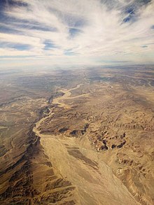
The Arava Stream is an intermittent stream that flows from the approximate mid-point of the Arava desert in Israel's Southern District northward. It is 89 km long, and in many parts, serves as the actual border between Israel and Jordan. The stream originates on the crest of the Notza Ridge, which forms the watershed divide between the Dead Sea and the Red Sea, and from which all streams in the Arava desert flow either north to the Dead Sea or south to the Red Sea. The stream's prominent tributaries include: Nahal Paran, Nahal Barak, Nahal Tzin, Nahal Tzafit, and Nahal Nekorot. In addition to Israel and Jordan, parts of its drainage basin are in the Sinai Peninsula, Egypt.

Wadi Auja, also spelled Ouja, known in Hebrew as Nahal Yitav is a valley or stream, in the West Bank, originating near the Ein Samia spring and flowing to Al-Auja near Jericho before it runs into the Jordan River.