
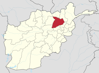
Baghlan is one of the thirty-four provinces of Afghanistan. It is in the north of the country. As of 2020, the province has a population of about 1,014,634.

Baghlan is a city in northern Afghanistan, in the eponymous province, Baghlan Province. It is located three miles east of the Kunduz River, 35 miles south of Khanabad, and about 500 metres above sea level in the northern Hindu Kush. Baghlan's capital, Pul-e-Khumri, is known to be an economic hub connected to eight other provinces by the Kabul-North highway.

The districts of Afghanistan, known as wuleswali are secondary-level administrative units, one level below provinces. The Afghan government issued its first district map in 1973. It recognized 325 districts, counting wuleswalis (districts), alaqadaries (sub-districts), and markaz-e-wulaiyat. In the ensuing years, additional districts have been added through splits, and some eliminated through merges. In June 2005, the Afghan government issued a map of 398 districts. It was widely adopted by many information management systems, though usually with the addition of Sharak-e-Hayratan for 399 districts in total. It remains the de facto standard as of late 2018, despite a string of government announcements of the creation of new districts.
Bibi Ayesha is a military leader and the only known female warlord in Afghanistan. She controls a force of 50-150 men in the Nahrin district of Baghlan Province. Also known as Kaftar, she operated for at least two decades, fighting against Soviet troops and then the Taliban militia as part of Jamiat-e Islami.
Puli Hisar or Pul-e-Hesar is a district in Baghlan province, Afghanistan.
Farang wa Gharu or Firing wa Gharu is a district in Baghlan province, Afghanistan. It was created in 2005 from part of Khost wa Fereng District.
Guzargahi Nur or Gozargah-e-Noor is a district in Baghlan province, Afghanistan. It was created in 2005 from part of Khost wa Firing District.
Khwaja Hijran is a district in the Baghlan Province of Afghanistan. The district was created in 2005 from part of Andarab District. The name of the district has already been changed and its new one is Jalga. It has a population of about 23,000, and its main village is Pansíri.
Andarab is district located in the southern part of Baghlan Province, Afghanistan. The estimated population of Andarab in 2004 was roughly 120,642. The district centre is the village of Andarab, which is named after the Andarab valley in which it is located.

Baghlani Jadid, is a district of Baghlan Province in northern Afghanistan. It has a population of about 119,607.

Dushi district is located in the central part of Baghlan Province, Afghanistan. It lies on the major Kabul-Kunduz highway. The population of the district was estimated to be around 57,160 in 2004. Hazaras are around 60% of the population and make up the majority in the district, followed by Tajiks (39%). The centre of the district is Dushi. Dushi was considered contested between the Afghan Government and the Taliban in late 2018.

Khinjan District is located in the southern part of Baghlan province in the Hindu Kush mountains. The capital is the town of Khenjan. The main Kabul-Kunduz highway passes through the district from south to west. Ethnic Tajiks makes up around 85% of the total population while the Pashtuns, Hazara and Uzbeks, each at 5%, makes up the remaining 15% of the population.
Nahrin is a district in the central part of Baghlan province in Afghanistan. To the west lie the major towns of Baghlan and Puli Khumri. The district centre is Nahrin. The population of the district was estimated to be around 57,509 in 2004, of which 60% are Tajiks, 35% Pashtun and 5% Uzbeks.
Tala wa Barfak is a district situated in the most southwestern part of Baghlan province, Afghanistan, and its capital is Tala wa Barfak village.
The Ali abad District is situated in the southern part of Kunduz Province, Afghanistan. It borders the Baghlan Province to the south, Chahar dara District to the west, Kunduz and Khan Abad districts to the north and Takhar Province to the east.
Baghlan was a district in Baghlan Province, Afghanistan. The main town of the district was also known as Baghlan. In 2005, Baghlan was annexed into the district of Baghlani Jadid, also in Baghlan Province.

Puli Khumri, also spelled Pul-i-Khumri or Pol-e Khomri, is a district of Baghlan province, Afghanistan.
Mohammad Panah was a prominent Afghan military commander loyal to Ahmad Shah Massoud. Panah earned popularity as he successfully fought in various soviet incursions in the Panjsher valley and northern areas of Afghanistan. Following the withdrawal of USSR forces from Afghanistan and the subsequent collapse of the communist regime in Kabul, Panah was a commander alongside Mohammad Fahim in the northern Kabul fronts fighting first Hezb-e-islami Hekmatyar and then the Taliban. He was killed in Paghman District during a Taliban offensive on Kabul.
The Kunduz River is a tributary of the Amu Darya in northern Afghanistan. It rises in Bamyan Province in the Hindu Kush, and in its upper reaches is also known as the Bamyan River or the Surkhab River. After passing through Baghlan Province and Kunduz Province, the Kunduz River merges into the Amu Darya.

On 11 June 2012, two moderate earthquakes struck northern Afghanistan, causing a large landslide. The landslide buried the town of Sayi Hazara, trapping 71 people. After four days of digging, only five bodies were recovered and the search was called off. Overall, 75 people were killed and 13 others were injured.
