Related Research Articles
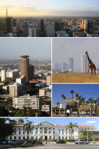
Nairobi is the capital and largest city of Kenya. The name is derived from the Maasai phrase Enkare Nairobi, which translates to 'place of cool waters', a reference to the Nairobi River which flows through the city. The city proper had a population of 4,397,073 in the 2019 census.

Busia is a town in Kenya. It is the capital and largest town of Busia County.

Ruiru is a municipality and sub-county in Kiambu County, Kenya. It sits within the greater Nairobi Metropolitan region. According to the 2019 national population census, Ruiru was the 4th largest urban centre in Kenya by population. The name Ruiru is of the Kikuyu origin and possibly relates to the black cotton soil that is found in most parts of Ruiru.
Malaba, Kenya is a town in Teso North Sub-County, Busia County, on Kenya's western border with Uganda. It sits across the Malaba River, which forms the international border from Malaba, Uganda.

Mombasa Road, also known as the Nairobi–Mombasa Road, or Mombasa–Nairobi Road or A109 Road (Kenya) is the main road between Nairobi, Kenya's capital and largest city and Mombasa, the country's largest port city. The road is a component of the Northern Corridor. It is part of the Lagos–Mombasa Highway.
The Kampala–Jinja Highway is a road in Uganda, connecting the cities of Kampala and Jinja. Sometimes referred to as Kampala–Jinja Road, it is a busy road, with several towns, trading centers and other points of interest along the way. As of October 2016, a new, wider, four-lane dual carriageway expressway, the Kampala–Jinja Expressway, is proposed to be constructed south of the present highway to relieve traffic and complement existing transport infrastructure between Kampala and Jinja.
Dagoretti is an area in the western part of Nairobi, the capital of Kenya. It straddles the Nairobi and Kiambu County boundary with the Dagoretti Road Reserve marking the psychological border point heading Northerly and North-Easterly. Administratively it is one of eight divisions of Nairobi. The Dagoretti division is divided into six Locations. The former electoral Dagoretti Constituency had the same boundaries as the now defunct Dagoretti division.
Dongo Kundu Bypass Highway, also Mombasa Southern Bypass Highway , is a road under construction in Kenya. When completed, it will connect Mombasa Mainland West to Mombasa Mainland South, without entering Mombasa Island.
The Malindi–Bagamoyo Highway, also Coastline Transnational Highway, is a road in Kenya and Tanzania, connecting the cities of Malindi and Mombasa in Kenya to Tanga and Bagamoyo in Tanzania.
Mavueni is a neighborhood in the city of Kilifi, in Kenya's Kilifi County.
The Nairobi–Malaba Road, also Nairobi–Uganda Road or A104 Road (Kenya) is a major highway in Kenya, the largest economy in the East African Community. The road connects Nairobi, the capital and largest city in Kenya, with the border town of Malaba at the international border with Uganda.
The Mombasa–Nairobi Expressway or Nairobi–Mombasa Expressway, also known as the Nairobi–Mombasa Highway, is a proposed four-lane toll highway in Kenya. The highway will link Nairobi, the capital and largest city of Kenya to Mombasa, the largest seaport of the country. The new highway is expected to cut travel times between the two cities from the current 6 to 10 hours to approximately four hours.
The Kenya Standard Gauge Railway (SGR) is a partially finished railway system connecting Kenya's cities. Once completed, it will link the country to the neighboring country of Uganda, and through Uganda, to South Sudan, the Democratic Republic of the Congo, Rwanda, and Burundi. There are also plans to link to Addis Ababa, in neighboring Ethiopia to the north. The first segment, between Mombasa and Nairobi, opened passenger rail service in June 2017, and freight rail service in January 2018. Other segments are under construction or planned. The new standard gauge railway is intended to replace the old, inefficient metre-gauge railway system.
The Nairobi–Nakuru–Mau Summit Highway is a road in Kenya, connecting the capital city of Nairobi, in Nairobi County, with the towns of Naivasha, Nakuru and Mau Summit, in Nakuru County.
Nairobi Western Bypass Highway is a road in Kenya. It connects the town of Kikuyu to the town of Ruaka, both in Kiambu County.
The Nairobi Eastern Bypass Highway is a road in Kenya, forming a semi-circle through the south-eastern and north-eastern neighbourhoods of the capital city of Nairobi. The road allows traffic from Mombasa, destined for the central parts of Kenya to bypass downtown Nairobi, thereby reducing traffic congestion in the city's central business district.
Nairobi Northern Bypass Highway is a road in Kenya, the largest economy in the East African Community. It connects the neighbourhood of Ruaka to the neighborhood of Ruiru, both in Kiambu County.
The A8 road is a road in Kenya that spans 923 kilometers. It connects the Ugandan border to the port city of Mombasa, passing through Eldoret and Nairobi. The road is one of the main transportation routes in Kenya, providing an east–west connection. It also serves as a route for international traffic to and from Uganda.
References
- ↑ Kibet, Lonah (23 May 2013). "Smooth ride for motorists ahead as Southern by-pass works begin". The Standard (Kenya) . Nairobi. Retrieved 5 March 2019.
- ↑ Globefeed.com (5 March 2019). "Distance between Central Nairobi, Kenya and DTB Centre, Kenya". Globefeed.com. Retrieved 5 March 2019.
- ↑ "Location of the Nairobi Southern Bypass Highway" (Map). Google Maps . Retrieved 5 March 2019.
- ↑ Globefeed.com (5 March 2019). "Distance between DTB Centre Nairobi, Kenya and Gitaru, Kenya". Globefeed.com. Retrieved 5 March 2019.
- 1 2 Patrick Thuita (18 August 2016). "Nairobi Southern Bypass now set for official opening". Nairobi: Constructionkenya.com. Retrieved 5 March 2019.
- ↑ Daily Nation News (8 February 2009). "Bypass construction starts without approval from environmental body". Daily Nation . Nairobi. Retrieved 5 March 2019.
- ↑ Antony Kiganda (27 June 2016). "Nairobi Southern bypass nearing completion". Nairobi: Construction Review Online. Retrieved 5 March 2019.
- 1 2 Mathenge, Oliver (2 November 2016). "Presidents Uhuru and Magufuli open Southern Bypass to decongest city". The Star (Kenya) . Nairobi. Retrieved 5 March 2019.