Khaira is a village in Ludhiana district in the Indian state of Punjab.
Berhampore, also known as Baharampur, is a city and a municipality in the state of West Bengal, India. Berhampore is the administrative headquarters of the Murshidabad district. As of 2011 census, Berhampore is the seventh largest city in West Bengal. It is located about 200 km (124 mi) from Kolkata, the state capital.

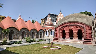
Cossimbazar is a sub-urban area of Berhampore city in the Berhampore CD block in the Berhampore subdivision of Murshidabad district in the Indian state of West Bengal.

Beldanga is a municipality town under the Berhampore subdivision of Murshidabad district in the state of West Bengal, India. Beldanga is an important trade centre of this district.
Gora Bazar is a census town located in the community development block of Berhampore, Berhampore subdivision, Murshidabad district, West Bengal, India. It is situated at an elevation of 18 meters above sea level.
Harharia Chak is a census town in the Raninagar I CD block of the Domkal subdivision in the Murshidabad district in the Indian state of West Bengal.
Kandi is a sub-divisional city and municipality in Murshidabad district in West Bengal, India. It is the headquarters of the Kandi subdivision and is located on the east bank of Kana Mayurakshi River. The town is known for being one of the oldest municipal bodies in India, having acquired municipality status in 1869. The area is also known as the 'rice store' of Murshidabad district, owing to its large production of rice.

Nawabganj Sadar is an upazila of Nawabganj District in the Division of Rajshahi, Bangladesh.

Godagari is an Upazila of Rajshahi District in the Division of Rajshahi, Bangladesh. This is the place where Mahananda river fall to Padma or Ganges.
Lalgola is a census town in the Lalgola CD block in the Lalbag subdivision of Murshidabad district, West Bengal. It is situated about 225 kilometres (140 mi) north of Kolkata, near the head of the Ganges delta. It is a terminal railway station on the Ranaghat-Lalgola branch line. The distance between Lalgola railway station and Krishnapur railway station is one of the shortest distance between two railway stations in India (1.7 km). It is also a border checkpoint but presently non functional.

Bhagawangola I is a community development block that forms an administrative division in the Lalbag subdivision of Murshidabad district in the Indian state of West Bengal.

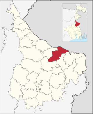
Raninagar II is a community development block that forms an administrative division in the Domkol subdivision of Murshidabad district in the Indian state of West Bengal.

Murshidabad-Jiaganj is a community development block that forms an administrative division in the Lalbag subdivision of Murshidabad district in the Indian state of West Bengal.
Bhagawangola II is a community development block that forms an administrative division in the Lalbag subdivision of Murshidabad district in the Indian state of West Bengal.

Lalgola is a community development block that forms an administrative division in the Lalbag subdivision of Murshidabad district in the Indian state of West Bengal.
Sagarpara is a village and gram panchayat in the Jalangi CD block in the Domkol subdivision of Murshidabad district in West Bengal, India. It is 2.5 kilometres from the Padma River.
Bhonpur is a village that are located near Boinchi in Hooghly district, West Bengal, India. It is under Pandua police station. Approximately it is 3 km apart from this region's main town Boinchi.
Gakhirkhowa Para is a village located in the west side of the Mangaldai town under Danhee Mouza of Darrang district state Assam. Its residents practice both Hinduism and Islam. The historical Darrangi Koch Raja's Raj Howly is situated in this village. The road distance from Mangaldai to Gakhirkhowapara is nearly 3 km (1.9 mi). The village connects with the city of Mangaldai through Mangaldai Patharughat Khairabari Road. The village operates under the post office of Janaramchowka( জনাৰামচৌকা ), and its PIN No is 784529. Gakhirkhowa Para has a population of 1639, 805 of which are male and 834 are female as per Population Census 2011.
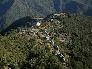
Khamlang village is situated on the southern part of Ukhrul District, Manipur, India. It is inhabited by Khameon a Tangkhul Naga tribe. It is situated 2 km away from headquarter of Sub-Division, Kasom Khullen, 137 km away from district headquarter Ukhrul and 59 km from state capital Imphal, Manipur.

Hathlangoo previously known as Hashmatpora is a village in the Sopore tehsil of Baramulla district, in the Indian union territory of Jammu and Kashmir. It is located 8 km (5.0 mi) away from sub-district headquarter Sopore and 22 km (14 mi) away from district headquarters Baramulla. It is one of the largest village in Zaingair. The Hathlangoo village has Janwara Village in the South, Magraypora in the North, Botingoo in the Northwest, Malmapanpora in the West and Wular Lake in the East.