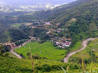
Shirui, initially called Shiroy/Shiroi, is a village located north of Ukhrul in Ukhrul district, Manipur state, India. The village is 15 kilometers from Ukhrul. National Highway 150 Imphal-Kohima via Jessami passes through the village. The village is divided into two parts, Shirui ato and Shirui aze; however, both the parts are under one chief. Shirui is famous for the rich and flora found on Shirui Kashong or Shirui peak and especially for blooming of the rare Lilium mackliniae during the start of Monsoon. The village is flanked by Ukhrul in the west, Langdang in the south, Mapum in the east, Sihai in the North east and Lunghar in the north. Locally inhabitants speak Shirui dialect which belongs to the Tibeto-Burman language family.
Nungshong Khullen is located south of Ukhrul in Ukhrul district, Manipur state, India. The village is about 30 kilometers from Ukhrul via the state highway that connects Ukhrul-Kamjong via Shangshak. The shorter un-metalled road from Ukhrul to Nungshong khullen is about 15 kilometers. Construction of a new road under PMGSY to connect the neighboring villages with Ukhrul is underway for which there were reports of irregularities on the part of the executing agencies. Nungshong is flanked by Hungpung in the west, Shangching in the south, Choithar and Khangkhui in the north. Locally, the residents speak Nungshong dialect which belongs to the Tibeto-Burman language family.
Phungyar is a small town located south of Kamjong in Kamjong district, Manipur state, India. It is also the name of a sub division of the district. The town is about 50 kilometers from Ukhrul and is partially connected by National Highway 150 that connects Imphal and Kohima via Ukhrul and Jessami. The town is flanked by Khambi in the south, Loushing in the north and alang in the west. Locally, the inhabitants speak common tangkhul language and native village dialect which belongs to the Tibeto-Burman language family.
Pushing is a village located south east of Ukhrul in Ukhrul district, Manipur state, India. The village is about 32 kilometers from Ukhrul and is partially connected by National Highway 150 that connects Imphal and Kohima via Ukhrul and Jessami and Kamjong-Imphal state highway. The village is flanked by Mapum in the north, Gamnom in the south, Ronshak in the east and Khangkhui in the west. Locally, the inhabitants speak Pushing tui which belongs to the Tibeto-Burman language family.
Maku is a village located south east of Ukhrul in Ukhrul district, Manipur state, India. The village is about 32 kilometers from Ukhrul and is partially connected by National Highway 150 that connects Imphal and Kohima via Ukhrul and Jessami and Kamjong-Imphal state highway. The village is flanked by Shingcha in the north, Langli in the south, Chatric in the east and Yengtem in the west. Maku is a major and strategic junction for the neighboring remote village as the state highway and Inter Village Roads (IVR) converges in the vicinity of the village. Locally, the inhabitants speak Maku tui which belongs to the Tibeto-Burman language family.
Yengtem is a village located south of Ukhrul in Ukhrul district, Manipur state, India. The village is about 40 kilometers from Ukhrul and is partially connected by National Highway 150 that connects Imphal and Kohima via Ukhrul and Jessami and Kamjong-Imphal state highway. The village is flanked by Gamnom in the north, Apong village in the south, Maku in the east and Shangshak in the west. Yengtem is a major and strategic junction for the neighboring remote village as the state highway and Inter Village Roads (IVR) converges in the vicinity of the village. Locally, the inhabitants speak Yengtem tui which belongs to the Tibeto-Burman language family.
Langli is a village located southeast of Ukhrul in Ukhrul district, Manipur state, India. The village is about 60 kilometers from Ukhrul and is partially connected by Ukhrul-Kamjong State highway. The village is flanked by Maku in the north, Kamjong village in the south, the Chatric in the east and Apong in the west. The village is divided into two major parts with separate settlements; Langli K and R Langli.
Shingcha is a village located southeast of Ukhrul in Ukhrul district, Manipur state, India. The village is about 45 kilometers from Ukhrul and is partially connected by Ukhrul-Kamjong State highway. The village is flanked by Pushing in the north, Maku in the south, the Langkhe in the east and Shangshak in the west.
Kamjong is the headquarter of Kamjong district, Manipur state, India. The village is about 120 kilometers from Imphal and is connected by Ukhrul-Kamjong State highway. This District headquarter is flanked by Langli in the north, Bungpa in the south, the Phange in the east and Dangthi in the west.
Ningthi is a village located west of Kamjong in Kamjong district, Manipur state, India. The village is about 20 kilometers from Kamjong and is partially connected by Ukhrul-Kamjong State highway and inter village road constructed in 2015. Ningthi is flanked by Kamjong in the east, Phungyar in the west, Tusom in the south and Hangkau in the north. Ningthi river is the main tributary of Chindwin river of Myanmar.
Seikhor is a village located west of Ukhrul in Ukhrul district, Manipur state, India. The village falls under Ukhrul sub division. Seikhor is partially connected by the old Imphal-Ukhrul road and is about 18 kilometers from Ukhrul. Seikhor is flanked by Pharung in the east, Teinem in the west, Tashar in the south and Ngainga in the north. Locally, the inhabitants speak Seikhor dialect that belongs to the Tibeto-Burman language family.
Lamlang also popularly referred as Lamlang Gate is a village located west of Ukhrul in Ukhrul district, Manipur state, India. The village falls under Ukhrul sub division. The old Imphal-Ukhrul road passes through the village and is about 19 kilometers from Ukhrul. Lamlang is flanked by Seikhor in the north, Pharung in the east, Tashar in the south and Sirarakhong in the west. Locally, the inhabitants speak Lamlang dialect that belongs to the Tibeto-Burman language family.
Bungpa is a generic reference to two villages, Bungpa Khullen and Bungpa Khunou located south of Ukhrul in Ukhrul district, Manipur state, India. The village falls under Kamjong sub division. The villages are connected by Ukhrul-Kamjong state highway. Bungpa is flanked by Phungyar in the west, Grihang in the south, Lakhan in the east and Kamjong in the north. Locally, the inhabitants speak Bungpa dialect that belongs to the Tibeto-Burman language family.
Grihang is a village located south of Ukhrul in Ukhrul district, Manipur state, India. The village falls under Kamjong sub division. The village is connected by Ukhrul-Kamjong state highway. Grihang is flanked by Tusom in the west, Ningchou in the south, Molvailup in the east and Bungpa in the north. Locally, the inhabitants speak Grihang dialect that belongs to the Tibeto-Burman language family.
Ningchou is a village located south of Ukhrul in Ukhrul district, Manipur state, India. The village falls under Kamjong sub division. Ningchou is connected by Ukhrul-Kamjong state highway. The village is flanked by Patbung in the west, Nambisha in the south, Kongkan in the east and Kamjong in the north. Locally, the inhabitants speak Ningchou dialect that belongs to the Tibeto-Burman language family. Some researchers are of the view that the dialect spoken by the inhabitants has some affinity to that of the Koireng tribe.
Kangpat is a generic reference to two villages, Kangpat Khullen and Kangpat Khunou located south of Ukhrul in Ukhrul district, Manipur state, India. The village falls under Kamjong sub division. The two villages are connected by Ukhrul-Kamjong state highway. Kangpat is flanked by Sorbung and Punge in the west, Choro in the south, Skipe in the east and Nambisha in the north. Locally, the inhabitants speak Kangpat dialect that belongs to the Tibeto-Burman language family. Some researchers are of the view that the dialect spoken by the inhabitants has some affinity to that of the Koireng tribe.
Skipe is a border village on the side of India in the Indo-Myanmar international border. The village is located south of Ukhrul in Ukhrul district, Manipur state, India. Skipe falls under Kamjong sub division. The village is partially connected by Ukhrul-Kamjong state highway. Skipe is flanked by Chindwin river in the east, Konkan Thana in the north, Kangpat in the west and Namlee in the south. Locally, the inhabitants speak Skipe dialect that belongs to the Tibeto-Burman language family. Some researchers are of the view that the dialect spoken by the inhabitants has some affinity to that of the Koireng tribe.
Punge is a small village located west of Kamjong in Kamjong District, Manipur state, India. The village falls under Phungyar sub division. The village is partially connected by Ukhrul-Phungyar state highway and Shangshak-Yairipok district road. Punge is flanked by Mawai in the west, Sorbung in the south, Kangpat in the east and Sorde in the north. Locally, the inhabitants speak Punge dialect that belongs to the Tibeto-Burman language family.
Sorde is a village located south-west of Kamjong in Kamjong District, Manipur state, India. The village falls under Phungyar sub division. The village is partially connected by Ukhrul-Phungyar state highway and Shangshak-Yairipok district road. Sorde is flanked by Khamlang in the west, Punge in the south, Kangpat in the east and Phungyar in the north. Locally, the inhabitants speak Sorde dialect that belongs to the Tibeto-Burman language family.

Khambi is a village located west of Kamjong in Kamjong District, Manipur state, India. The village falls under Phungyar sub division. The village is partially connected by Ukhrul-Phungyar state highway and Shangshak-Yairipok district road. Khambi is flanked by Khamlang in the west, Sorde in the south, Kangpat in the east and Phungyar in the north. Locally, the inhabitants speak Khambi dialect that belongs to the Tibeto-Burman language family.

