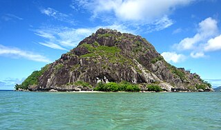
Nananu-i-Ra is an island in Fiji about 3 kilometers off the north coast of the main island of Viti Levu, near the town of Rakiraki in Ra Province. The island is 3.5 square kilometers and has a maximum elevation of 180 meters. The name "Nananu-I-Ra" means "Daydream of the West" in Fijian. Fijian mythology holds that Nananu-I-Ra is the point of departure for disembodied spirits leaving this world for the afterlife.
The highest peak and lookout point on the eastern side bears the remnants of an ancient settlement complete with fractured and decorated pottery in low-lying areas and the legend of mythical creatures.
Tribal-era fish traps were the main source of food and still exist in some places on Nananu-i-Ra.
The island holds an immense geopolitical importance as it is located between the ports and landing points between Viti Levu and Vanua Levu.
Nananu-i-Ra is privately owned. Safari Lodge owns a resort specific ally for wind sports - Windsurfing / Kitesurfing and Foiling.
The nearest township is Rakiraki. A full report is available from Town and Country Planning Fiji that describes the ecology and natural aspects of Nananu-i-Ra.
Wind turbines are the preferred energy source to power most residents' homes.
Neighbouring islands include Dolphin Island and Nananu-i-Cake Island.
Fiji is a group of volcanic islands in the South Pacific, lying about 4,450 kilometres (2,765 mi) southwest of Honolulu and 1,770 km (1,100 mi) north of New Zealand. Of the 332 islands and 522 smaller islets making up the archipelago, about 106 are permanently inhabited. The total land size is 18,272 km2 (7,055 sq mi). It has the 26th largest Exclusive Economic Zone of 1,282,978 km2 (495,361 sq mi).
Vanua Levu formerly known as Sandalwood Island, is the second largest island of Fiji. Located 64 kilometres to the north of the larger Viti Levu, the island has an area of 5,587.1 square kilometres (2,157.2 sq mi) and a population of 135,961 as of 2007.
Viti Levu is the largest island in the Republic of Fiji. It is the site of the nation's capital, Suva, and home to a large majority of Fiji's population.
The Sigatoka River is the longest and widest river in Fiji. Located on the island of Viti Levu, the Rewa originates in Tomanivi, the highest peak in Fiji, and flows southeast for 145 km to Laucala Bay, near Suva. The Rewa River drains approximately one-third of Viti Levu.
Ovalau is the sixth largest island in Fiji. It is located in Lomaiviti Archipelago. Situated at 17.70° South and 178.8° East,, the island is about 13 kilometers long and 10 kilometers wide. It covers a total area of 106.4 square kilometers and has a population of around 9,100, approximately half of the population of Lomaiviti Province over the 1956–2007 period. Levuka, Fiji's former capital, is the largest of 24 towns and villages on the island, and is the only urban area in Lomaiviti. All settlements are coastal, except Lovoni in the interior of the island.
Rakiraki is a district in Fiji's Ra Province. It is located between Tavua and Korovou when travelling along the Kings Road, on the northern coast of Viti Levu, Fiji's largest island.
Vaileka commonly known as Rakiraki town is an urban centre in Fiji, in the Rakiraki region of Ra Province. It had a population of 3,361 at the 1996 census, the last to date. It is not officially a "town," however: that term is legally reserved for urban centres with organized municipal governments. The status of the area may be changed. The Fiji Times reported on 4 October 2006 that Uraia Waqa, Chairman of the Rakiraki Local Government Authority, had called for Vaileka to be officially incorporated as a Town, to be known as Rakiraki Town, in order to attract government investment. Local Government and Urban Development Minister Chaitanya Lakshman was reported to be sympathetic to the proposal.
Nadroga-Navosa is one of the fourteen provinces of Fiji and one of eight based in Viti Levu, Fiji's largest island. It is about 2,385 square kilometers and occupies the South-West and Central areas of Viti Levu, Fiji's principal island. The province includes the Mamanuca Archipelago,Malolo Islands, off the west coast of Viti Levu, Vatulele, as well as the remote Conway Reef in the southwest. The population at the 2017 census was 58,931, being the fifth largest province. The main town in Nadroga-Navosa is Sigatoka, with a population of 9622.
Ra is one of the fourteen provinces of Fiji. Occupying the northern area of Viti Levu, the largest island, it is one of eight Viti Levu-based Provinces. With a land area of 1,341 square kilometers, it had a population of 30,432 in 2017 census. The main urban centre is at Vaileka, with a population of 3,361 in 1996.
Tailevu is one of the 14 provinces of Fiji. Its capital town is Nausori which lies along the banks of the Rewa River.
Tavua F.C. is a Fijian football team playing in the first division of the Fiji Football Association competitions. It is based in Tavua, which is situated on the western side of the main island of Viti Levu, between the town of Rakiraki and the town of Ba. Their home stadium is Garvey Park. Their uniform is gold shirt, black shorts and black socks.
Rakiraki F.C. is a Fijian football team playing in the second division of the Fiji Football Association competitions. It is based in Rakiraki, which is situated on the northern side of the main island of Viti Levu. Their home stadium is the Ra Sports Grounds. Their uniform is maroon shirt, white shorts and maroon socks.
Tavua is a district in the Western Division on the north west coast of the island of Viti Levu in Fiji. It is part of the province of Ba. It is situated some 20 kilometers by road from Ba town. Its main economy is sugar cane, although the establishment of Tavua township was the result of a gold mine in Vatukoula, which is in the interior of Viti Levu but easily accessible from Tavua. A wharf, used by the mine, also exists at Vatia a few kilometres near the coast. The wharf is of historical significance as it was used as the main route of transportation from Suva to the western districts before the coastal road was built. The district is home to Tavua F.C., who play at [[Garvey Park (Fiji)] in Tavua.
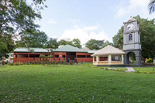
The Fiji Museum is a museum in Suva, Fiji located in the capital city's botanical gardens, Thurston Gardens.
Sir Harold Paton Mitchell, 1st Baronet, JP, DL was a British businessman and Conservative politician.
Natovi Landing is a ferry port in Tailevu Province, Fiji, linking cargo trucks to the three big islands of Fiji. Nearby Korovou is the closest drop off for travelers trekking with local buses, the post is mainly service by Patterson Brothers Shipping Company LTD.
Tropical Depression 10F was a small tropical depression that became the deadliest tropical cyclone of the 2004 season, claiming 11 lives in the Fiji islands.
Nananu-i-Cake [nɑː.nɑːˈnuː iː ðɑːˈkeː] is an island in Fiji less than one kilometer off the coast of the main island of Viti Levu, near the Rakiraki-district in Ra Province.
Severe Tropical Cyclone Ana was one of three tropical cyclones to impact the island nation of Fiji towards the end of January 2021. The fifth tropical disturbance, third tropical cyclone and second severe tropical cyclone of the 2020–21 South Pacific cyclone season, Ana was first noted as Tropical Disturbance 05F during January 26, while it was located about 220 km (135 mi) to the northeast of Port Vila in Vanuatu. Over the next few days, the system moved eastwards and gradually developed further, before it was declared to be a tropical cyclone and named Ana during January 29. Over the next day, the system moved south-eastwards towards Fiji before it made landfall on the island of Viti Levu. After emerging into the Pacific Ocean, the system intensified into a Category 3 severe tropical cyclone, before it rapidly degenerated into a subtropical low during February 1.
Naval Base Fiji was a naval base built by the United States Navy in 1942 to support the World War II effort. The base was located on Fiji in the Central Pacific Ocean. The base was built as one of many advance bases in the island-hopping campaign towards the Empire of Japan. The US Navy built seaports, seaplane bases and airfields used for staging in the Pacific War.
This page is based on this Wikipedia article Text is available under the CC BY-SA 4.0 license; additional terms may apply. Images, videos and audio are available under their respective licenses.