
Granada is a city in western Nicaragua and the capital of the Granada Department. With an estimated population of 105,862 (2022), it is Nicaragua's ninth most populous city. Granada is historically one of Nicaragua's most important cities, economically and politically. It has a rich colonial heritage, seen in its architecture and structure.
Carazo is a department in Nicaragua. It covers an area of 1,081 km2 and has a population of 198,395. The capital is Jinotepe.
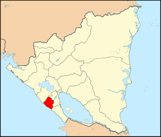
Granada is a department in Nicaragua. It covers an area of 1040 km2 and has a population of 215,965. The capital is the city of Granada, one of North America's oldest cities.

Masaya is a department in Nicaragua. It is the country's smallest department by area (611 km2) and has a population of 397,632. The capital is the city of Masaya. It is famous among Nicaraguan people for its nickname, "La Cuna Del Folklore" which translates to. It is also the site of the Masaya Volcano, an active 635m volcano which last erupted in 2016. The Indigenous inhabitants of Masaya are the Nahuas and the Chorotegas, the Nahuas dominate the cultivation and production of cocoa beans in the municipality of Masatepe.

Nueva Segovia is a department in Nicaragua. It covers an area of 3,491 km2 and has a population of 275,291. Nueva Segovia is also home to the indigenous Chorotegas and Nahuas. The capital is Ocotal.

Bluefields is the capital of the South Caribbean Autonomous Region in Nicaragua. It was also the capital of the former Kingdom of Mosquitia, and later the Zelaya Department, which was divided into North and South Caribbean Coast Autonomous Regions. It is located on Bluefields Bay at the mouth of the Bluefields River in the municipality of the same name.

Ocotal is the capital of the Nueva Segovia Department in Nicaragua, Central America and the municipal seat of Ocotal Municipality.
Dolores is a municipality in the Carazo department of Nicaragua. It is the smallest municipality in Nicaragua, as it consists only of the urban area or dwellings of its head town.

Jinotepe is a city and municipality in the Carazo department of Nicaragua.
Somotillo is a town and a municipality in the Chinandega department of Nicaragua.

Diria is a municipality in the Granada department of Nicaragua.

Somoto is a city and a municipality located in the hills of northern Nicaragua, and capital of the department of Madriz. It is around 20 km south-west of Ocotal and 51 km north-west of Estelí. It sits on the Pan-American Highway around 16 km from the Honduran border crossing at El Espino.

San Rafael del Sur is a town and a municipality in the Managua department of Nicaragua.

Ticuantepe is a town and a municipality in the Managua department of Nicaragua with an estimated population of 39,012.
Masatepe is one of the nine municipalities of the Department of Masaya in Nicaragua. It is located on the plateau of the villages 50 kilometers from Managua along the road to Masaya. It belongs to the tourist corridor of " Los Pueblos Blancos" on top of the coffee-producing Volcanic Plateau. The origin of the word "Masatepe" comes from Nahuatl Mazatl-tepec, «populated deer» or mazatl-tepetl, 'Deer Mountain', which comes from the Nicarao who still inhabit the municipality. Nicarao natives dominate the cocoa production in Masatepe.
San Juan de Oriente is a municipality in the Masaya department of Nicaragua.
Matiguás is a town and a municipality in the Matagalpa department of Nicaragua. It is also the twin city of Saarlouis in Germany. It is located 249 kilometres from Managua, and 75 kilometres from Matagalpa City, the department capital.
San Fernando is a municipality in the Nueva Segovia Department of Nicaragua.
Morrito is a municipality in the Río San Juan department of Nicaragua. As of 2018 the current mayor is Eda Griselda Medina.

Masaya is the capital city of Masaya Department in Nicaragua. It is situated approximately 14 km west of Granada and 31 km southeast of Managua. It is located just east of the Masaya Volcano, an active volcano from which the city takes its name. With an estimated population of 138,657 (2022), it is Nicaragua's fourth most populous city, and is culturally known as the City of Flowers.

