
Granada is a city in western Nicaragua and the capital of the Granada Department. With an estimated population of 105,862 (2022), it is Nicaragua's ninth most populous city. Granada is historically one of Nicaragua's most important cities, economically and politically. It has a rich colonial heritage, seen in its architecture and structure.
Jinotega is the capital city of the Department of Jinotega in north-central Nicaragua.

Lo Barnechea is a commune located in the northeastern sector of the province of Santiago and its area corresponds to 48% of this province. Its urban boundaries are: to the north with Los Andes of the Valparaíso region, to the west with Colina, to the southwest with Vitacura and Huechuraba, to the south with Las Condes and to the east with San José de Maipo. It developed around the old rural town of Lo Barnechea. Its population is heterogeneous, as it is inhabited by high- and medium-high-income families in sectors such as La Dehesa, Los Trapenses and El Arrayán, and also by medium-low- and low-income families, mainly in the towns of Lo Barnechea, Población La Ermita and Cerro Dieciocho.

San Juan Opico is a municipality in the La Libertad department of El Salvador.
Condega is a municipality in the Estelí department of Nicaragua. It was officially incorporated on June 9, 1962. Condega is situated on the Pan-American Highway at a distance of 185 kilometers north of Managua, and at an altitude of 560 meters above sea level.

Diriomo is a town and a municipality in the Granada department of Nicaragua.
Masatepe Masatepe is one of the nine municipalities of the Department of Masaya in Nicaragua. It is located on the plateau of the villages 50 kilometers from Managua along the road to Masaya. It belongs to the tourist corridor of " Los Pueblos Blancos" on top of the coffee-producing Volcanic Plateau. The origin of the word "Masatepe" comes from Nahuatl Mazatl-tepec, «populated deer» or mazatl-tepetl, 'Deer Mountain', which comes from the Nicarao who still inhabit the municipality. Nicarao natives dominate the cocoa production in Masatepe.

El Castillo is a municipality located on the Río San Juan in the Río San Juan Department of Nicaragua. The settlement of what would eventually become the municipality of El Castillo began in 1673, when construction of the Fortaleza de la Limpia Pura e Inmaculada Concepción, was begun. The village of El Castillo eventually grew around the fortress, which continued to be strategically important to the Captaincy General of Guatemala until the late 18th century.

Masaya is the capital city of Masaya Department in Nicaragua. It is situated approximately 14 km west of Granada and 31 km southeast of Managua. It is located just east of the Masaya Volcano, an active volcano from which the city takes its name. With an estimated population of 138,657 (2022), it is Nicaragua's fourth most populous city, and is culturally known as the City of Flowers.

Manta is a municipality and town located in the northeast of the department of Cundinamarca (Colombia), 90 kilometres (56 mi) from Bogotá. It is located in the Almeidas Province in the Tenza Valley. Manta borders to the north Tibiritá, to the west Machetá, to the south Gachetá and to the east Guateque and Guayatá of the department of Boyacá.

Tourism in Nicaragua has grown considerably recently, and it is now the second largest industry in the nation. Nicaraguan President Daniel Ortega has stated his intention to use tourism to combat poverty throughout the country.
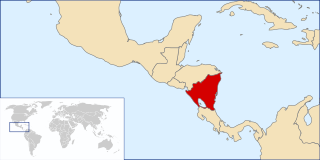
The following is an alphabetical list of topics related to Nicaragua.
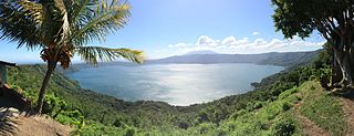
Laguna de Apoyo Nature Reserve is a nature reserve located between the departments of Masaya and Granada in Nicaragua. Lake Apoyo was declared a nature reserve in 1991 and is managed by the Ministry of the Environment and Natural Resources (MARENA) and comprises one of 78 protected areas of Nicaragua. Activities within the Laguna de Apoyo Nature Reserve are regulated by its management plan, approved in 2010, which prohibits the construction of housing within the reserve and use of motorized vehicles on the lake. Geological data suggests that Lake Apoyo originated about 23,000 years ago.
Las Gabias is a Spanish city and municipality located in the central southern part of the Vega of Granada, in the province of Granada, in the autonomous community of Andalusia, approximately 8 km from the provincial capital of Granada. It borders the municipalities of Vegas del Genil, Cúllar Vega, Churriana de la Vega, Alhendín, La Malahá, Chimeneas and Santa Fe. Las Gabias includes the localities of "Gabia Grande", the municipal capital, and "Gabia Chica" that were a unified with the region in 1973, in addition to the annexation of Híjar, Los Llanos, Pedro Verde and San Javier. The name may have originated from Hisn Caviar, which means "military tower", in allusion to the one that still exists in Gabia Grande. It is one of the most populous municipalities in Spain as well as one of the youngest, with the median age of inhabitants being only 34.3 years of age. In 2016, the population of Las Gabias surpassed 20,000, making it the third most populous municipality in the Granada Metropolitan Area, surpassed only by Granada and Armilla.

Tlaxiaco is a city, and its surrounding municipality of the same name, in the Mexican state of Oaxaca. It is located in the Tlaxiaco District in the south of the Mixteca Region, with a population of about 17,450.
Tlatlaya is one of 125 municipalities of the State of Mexico in Mexico. The municipal seat is the town of Tlatlaya which is the eleventh largest town in the municipality. The word “Tlatlaya” means when the hearth is black and red.
San Jose Villa de Allende is a town and municipal seat of the municipality of Villa de Allende. It is the fifth largest town in the municipality. It is located 70 kilometers to the west of the city of Toluca. Villa de Allende was named in honor of Ignacio Allende, a hero of the Mexican War of Independence.
Tejupilco is a municipality in the State of Mexico, Mexico, located approximately 100 kilometres (62 mi) southwest of the state capital Toluca, along Federal Highway 134. Its municipal seat is Tejupilco de Hidalgo. The municipality has a total area of about 1,327 km2 (512 sq mi), with a contrasting topography ranging from deep ravines and canyons to high ridges; the highest elevation within the municipality reaches some 1,117 metres (3,660 ft) asl. The 2005 census recorded a population of 62,547 inhabitants.
Luvianos is a small town and municipality located in the southwest of the State of Mexico. It gained municipal status in 2000. People can access Luvianos by driving Federal Road 134 south from Toluca, and then take a detour about 25 minutes north of Tejupilco. The name is derived from a hacienda what was established during colonial times.
El Castillo is a village of about 1,500 people situated on the southern bank of the Río San Juan in southern Nicaragua. It is one of 27 comarcas of the municipality of El Castillo, a subdivision of the Río San Juan Department. The village is situated approximately 6 kilometers from the border with Costa Rica, at the Raudal del Diablo rapids of the San Juan River. The site on which the village of El Castillo is built was initially established in 1673 as a Spanish fortification to defend against pirate attacks upon the city of Granada. The settlement of El Castillo and its fortress continued to be strategically important to the Captaincy General of Guatemala until the late 18th century.


