Nanyangachor

Last updated
Nanyangachor
Village
South Sudan adm location map.svg
Red pog.svg
Nanyangachor
Location in South Sudan
Coordinates: 5°29′56″N34°46′23″E / 5.498993°N 34.773102°E / 5.498993; 34.773102
CountryFlag of South Sudan.svg  South Sudan
Region Equatoria
State Eastern Equatoria
County Kapoeta East County
Payam Kauto Payam
Time zone UTC+2 (CAT)

Nanyangacor (or Nanyangacor) is a community in Eastern Equatoria state of South Sudan. It is in the Eastern Uplands of Kapoeta East County, near the border with Ethiopia. [1]

Contents

Location

Nanyangachor is about 180 kilometres (110 mi) northeast of Narus, in the dry season about a five-hour drive. In the rainy season the drive may take much longer. It is located on a plateau surrounded by mountains, and is much cooler than in the plains to the west. [2] Cattle play an important role in the economy. Cattle raiding with their neighbors, including the Turkana people to the south in Kenya, is endemic. Periodically the people conduct peace meetings to try to find a way to prevent further raids. Women have increasingly been involved. [3]

Education and health

The Catholic Diocese of Torit runs the Nanyang'achor Primary School. [4] The diocese also operates a primary health care center at Nanyangachor, with a catchment population of over 300,000 people from the Toposa and Nyangatom ethnic groups. [5] In 2007 there was an outbreak of measles in Nanyangachor, with 30 cases reported and one death as of 7 October. [6] A later report said that 821 children had died of the disease and 2,500 more had been affected. [7] By December that year the outbreak was under control. 20,551 children had been immunized in the villages of Naita, Bilamoi, Nakudochua, Kuron, Kauto areas and Nanyangachor west, a coverage of 60%. [8]

2010 food emergency

In March 2010 it was reported that Turkana from Kenya had again been conducting regular cattle raids in the area. The supply of food from Uganda and Kenya had deteriorated in 2010 due to lack of logistic support, poor road conditions and insecurity. People were managing to collect wild fruit, and had milk supplies. They were selling some animals for food in Narus and Kapoeta, but only to a very limited degree due to the danger and difficulty of the journey to market. Some children under five years old were suffering from Marasmus, caused by malnutrition. The World Food Programme was conducting a general food distribution. [9] School attendance had decreased due to hunger. There were serious shortages of basic drugs in Nanyangachor Hospital. [10]

Related Research Articles

<span class="mw-page-title-main">Eastern Equatoria</span> State of South Sudan

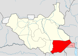
Eastern Equatoria is a state in South Sudan. It has an area of 73,472 km2. The capital City is Torit. On October 1, 1972, the state was divided into Imatong and Namorunyang states and was re-established by a peace agreement signed on 22 February 2020.

<span class="mw-page-title-main">Toposa people</span>

The Toposa are a Nilotic ethnic group in South Sudan, living in the Greater Kapoeta region of Eastern Equatoria state. They have traditionally lived by herding cattle, sheep and goats, and in the past were involved in the ivory trade. They have a tradition of constant low-level warfare, usually cattle raids, against their neighbors.

<span class="mw-page-title-main">Roman Catholic Diocese of Torit</span> Roman Catholic diocese in South Sudan

The Roman Catholic Diocese of Torit is a diocese located in Torit in the ecclesiastical province of Juba in South Sudan.

<span class="mw-page-title-main">Kapoeta</span> Town in Equatoria, South Sudan

Kapoeta is a town in South Sudan. It is located in Kapoeta South County, in Eastern Equatoria State, in southeastern South Sudan.

Ikotos County is an administrative area in the Eastern Equatoria state of South Sudan with headquarters in the town of Ikotos. The people, who live in the county's area by subsistence agriculture and cattle herding, are poverty-stricken. Years of civil war have made violence commonplace: most people have experienced the murder of a close family member. In 2009, AK-47 rifles were used in 42 per cent of killings.

Budi County is an administrative area of Eastern Equatoria state in South Sudan, with headquarters in Chukudum.

<span class="mw-page-title-main">Greater Kapoeta</span>

Greater Kapoeta is the name given to the eastern half of the erstwhile Eastern Equatoria State in South Sudan, at one time an administrative region with headquarters in the town of Kapoeta. Greater Kapoeta was divided between Kapoeta County and Budi County, named after the Buya and Didinga (BU-DI) people. Kapoeta County was later split into Kapoeta North, South and East counties.

Louis Lobong Lojore is a South Sudanese Politician and a military governor in the rank of brigadier general in the South Sudan People's Defence Forces (SSPDF) and the current governor of Eastern Equatoria State in South Sudan. He was the governor of Eastern Equatoria state from 2010 to 2015, governor of Kapoeta State from 2015 to 2020, and has been the governor of the recreated Eastern Equatoria state since 29 June 2020. Lobong is the longest serving governor in South Sudan.

<span class="mw-page-title-main">Namorunyang</span> Village in Equatoria, South Sudan

Namorunyang is a village and Payam of Kapoeta South County in Eastern Equatoria, South Sudan.

<span class="mw-page-title-main">Kapoeta South County</span> County in Equatoria, South Sudan

Kapoeta South County is an administrative region in Eastern Equatoria State. The county logo is a ram with horns and slightly bent tail. The county includes the Kapoeta Town, Machi and Namorunyang Payams.

Narus is a community in the Eastern Equatoria State of South Sudan. It is the headquarters of Kapoeta East County.

The Didinga Hills are an upland area in Eastern Equatoria of South Sudan, lying mainly within Budi County.

Nadapal is a community in the south west of Kapoeta East County, South Sudan near the border with the Rift Valley province of Kenya. The Nadapal belt is an area stretching 25 kilometres (16 mi) southward from the border with South Sudan to Lokichogio in Kenya.

Riwoto is a community in Eastern Equatoria state of South Sudan. It is a payam and village in Kapoeta North County.

Natinga originated from Didinga's common word "kitingatek" which literarily means let's force it.

<span class="mw-page-title-main">Kapoeta East County</span> County in Equatoria, South Sudan

Kapoeta East County is an administrative region of Eastern Equatoria state in South Sudan, bordered by Kenya to the south, Ethiopia to the east and Jonglei state to the west. It is part of the Greater Kapoeta region of the state. The largest ethnic group is the Toposa people. The principal town is Narus. The county includes the disputed Ilemi triangle, controlled by Kenya. The emblem of the county is a horned bull, with big humps and a large tail.

George Echom Ekeno is a politician who was deputy governor of Eastern Equatoria state in South Sudan, and was later appointed state minister for Environment, Wildlife Conservation & Tourism.

Loyoro is a community in Eastern Equatoria state of South Sudan, about 50 kilometres (31 mi) as the crow flies to the north east of Narus. It lies on the Loyoro River. Loyoro is part of the Narus parish of the Catholic Diocese of Torit.

Lolim is a community located in Eastern Equatoria state of South Sudan. It is on the road from Kapoeta to Narus. Lolim lies just north of the Loyuro River, which has a pool called Lolimi. The community is mainly made up of Toposa people.

Lobira is a community in Torit County, Eastern Equatoria state, South Sudan. It is on the southern road between Torit and Kapoeta, and lies to the north of Lobira hill.

References

  1. "Eastern Equatoria State Map" (PDF). UN Sudan IG. Retrieved 2011-07-28.
  2. Sister Theresa Baldini (September 2000). "A Sudanese Safari". MaryKnoll. Archived from the original on 2011-09-30. Retrieved 2011-07-28.
  3. "Quarterly Report" (PDF). USAID. January 1 – March 31, 2005. Retrieved 2011-07-28.
  4. "Education". Diocese of Torit. Retrieved 2011-07-28.[ permanent dead link ]
  5. "Nanyangachor". Catholic Diocese of Torit. Archived from the original on 2012-03-28. Retrieved 2011-07-27.
  6. "Sudan: Weekly report on activities (EHA/HAC) 1" (PDF). ReliefWeb. 7 Oct 2007. Retrieved 2011-07-27.[ permanent dead link ]
  7. "SOUTH SUDAN Food Security Update" (PDF). USAID. October 2007. Archived from the original (PDF) on 2011-09-27. Retrieved 2011-07-28.
  8. "Southern Sudan Health Update" (PDF). World Health Organization. Nov–Dec 2007. Archived from the original (PDF) on March 18, 2008. Retrieved 2011-07-28.
  9. "Southern Sudan Food Security Update" (PDF). Government of Southern Sudan with United Nation Organizations. April 30, 2010. Archived from the original (PDF) on March 26, 2012. Retrieved 2011-07-27.
  10. "Joint Weekly Report Sudan" (PDF). UN Resident Coordinator’s Support Office/Integrated Team. 6–14 March 2010. Retrieved 2011-07-27.