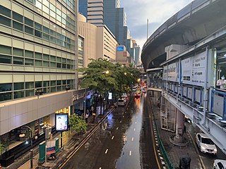
Si Lom Road is a major street in the Thai capital Bangkok, best known for its commercial neighbourhood, which, along with the nearby and roughly parallel Sathon Road, forms one of the city's main business districts. It runs in a southwest–northeast direction between Charoen Krung and Rama IV roads in the city's Bang Rak District, forming the boundary between Suriyawong Subdistrict to its north and Si Lom Subdistrict to its south. Si Lom was one of the earliest modern roads to be built in the city, and some of its side streets serve historic ethnic neighbourhoods from the late nineteenth century, while others are known as shopping and nightlife venues.

Bang Rak is one of the fifty districts (khet) of Bangkok, Thailand. It lies on the eastern bank of the Chao Phraya River, beyond Khlong Phadung Krung Kasem, which marked the old city boundary. Originating from riverside settlements dating from before the city's foundation, Bang Rak grew inland as new roads and canals were constructed through the area during the second half of the nineteenth century and the early twentieth, attracting communities of expatriates and developing into a major commercial district.

Sathon or Sathorn is one of the 50 districts (khet) of Bangkok, Thailand. The district is bounded by six other districts : Bang Rak, Pathum Wan, Khlong Toei, Yan Nawa, Bang Kho Laem, and Khlong San.

Galyani Vadhana, Princess of Naradhiwas was a princess of Thailand and the elder sister of King Ananda Mahidol and King Bhumibol Adulyadej. She was also a direct granddaughter of King Chulalongkorn and Queen Sri Savarindira and the aunt of King Vajiralongkorn.
Yan Nawa or Yannawa is one of the 50 districts (khet) of Bangkok, Thailand. The district is bounded by Rat Burana, Bang Kho Laem, Sathon, and Khlong Toei Districts of Bangkok. Its neighbor from east to south is Phra Pradaeng district of Samut Prakan province.
Princess of Naradhiwas University is a government sponsored university in Narathiwat, southern Thailand. It was founded under the act on 9 February 2005 by merging all educational institutions in the province. Those institutions are Narathiwat Technical College, Narathiwat Agricultural & Technology College, Takbai Vocational College, and Boromarjonani College of Nursing, Narathiwat.
Charoen Krung Road is a major road in Bangkok and the first in Thailand to be built using modern construction methods. Built during 1862–1864 in the reign of King Mongkut, it runs from the old city centre in Rattanakosin Island, passes through Bangkok's Chinatown, continues into Bang Rak district, where it formerly served the community of European expatriates, and ends in Bang Kho Laem. Construction of the road marked a major change in Bangkok's urban development, with the major mode of transport shifting from water to land. Charoen Krung Road was Bangkok's main street up to the early 20th century, but later declined in prominence. It is still home to many historic buildings and neighbourhoods, which are beset by changes as extension of the underground MRT is poised to drive new development.

Sathon Road is a major road that passes through the districts of Bang Rak and Sathon in central Bangkok, Thailand. It is an important transportation link between Phra Nakhon and Thonburi sides of Bangkok.

Chong Nonsi station is a BTS skytrain station, on the Silom line in Bang Rak District, Bangkok, Thailand. The station is located on Naradhiwas Rajanagarindra Road over the Chong Non Si Canal, in the heart of the Bangkok business area between Sathon and Si Lom Roads.

Si Phraya Road is a road in Bang Rak District, Bangkok, Thailand. It divides the areas of Maha Phruettharam and Si Phraya subdistricts. Built in 1906 by four noblemen of the rank phraya, the road runs from Si Phraya Pier at the mouth of the Phadung Krung Kasem Canal to Sam Yan Intersection, where it meets the Phaya Thai and Rama IV Roads.

Thanon Tok is a road junction in the Bang Kho Laem Subdistrict, Bang Kho Laem District, Bangkok. It is a point of intersection where Charoen Krung, Rama III and Mahaisawan Roads meet. The boundaries of the junction are considered to be where Charoen Krung and Mahaisawan Roads terminates, and where Rama III Road originate.

Chaloem Phan 53 Bridge is a bridge in Bangkok's Yan Nawa sub-district, Sathon district and Si Lom sub-district, Bang Rak District.

Chan Road, also known as Trok Chan, is a road and neighbourhood in Bangkok. It's a separate from Nang Linchi road in the area of Thung Maha Mek sub-district, Sathon district and runs through Chan - Naradhiwas intersection where it cuts across Naradhiwas Rajanagarindra road. In this phase, it also acts as a line between Sathon district's Thung Wat Don and Yan Nawa district's Chong Nonsi sub-district, then through two more intersections were Tai Duan Chan junction and Sathu - Chan junction as far as end at Trok Chan junction, where it combined with Charoen Krung road in the area of Wat Phraya Krai sub-district, Bang Kho Laem district, total distance is 7.0 km. At the end of the road on Charoen Krung side is close to two historic sites are Asiatique The Riverfront, originally, it was the location of the Danish maritime navigation company East Asiatic Company and Protestant Cemetery, include another place of education is Shrewsbury International School.

Chong Nonsi is one of the two khwaengs (sub-districts) of Yan Nawa District, Bangkok rim Chao Phraya River. In late 2018, it had a population of 48,277 people, with total area of 9.984 km2. It is the location of the Yan Nawa District Office. This Sub-District is also divided into 13 communities.

Khlong Chong Nonsi is a khlong (canal) in Bangkok's economic and financial district as well as the nearby Khlong Sathon.
Bang Phongphang is one of the two khwaengs (sub-districts) of Yan Nawa District, Bangkok, apart from Chong Nonsi. In December 2018 it had a population of 29,754 people, with total area of 6.678 km2. The sub-district is also divided into seven communities.

Naradhiwas Rajanagarindra Hospital is the main hospital of Narathiwat Province, Thailand and is classified under the Ministry of Public Health as a general hospital. It has a CPIRD Medical Education Center which trains doctors for the Faculty of Medicine of Princess of Naradhiwas University.

Rama III Road is a main road in inner Bangkok. The 12 km (7.5 mi) long road runs along the bend of Chao Phraya River on the Phra Nakhon side.

