Narsdorf

Last updated
Narsdorf
NarsdorfUntDorfstr.JPG
Street in Narsdorf (2012)
Location of Narsdorf
Narsdorf
Germany adm location map.svg
Red pog.svg
Narsdorf
Saxony location map.svg
Red pog.svg
Narsdorf
Coordinates: 51°1′N12°43′E / 51.017°N 12.717°E / 51.017; 12.717 Coordinates: 51°1′N12°43′E / 51.017°N 12.717°E / 51.017; 12.717
Country Germany
State Saxony
District Leipzig
Town Geithain
Area
  Total24.49 km2 (9.46 sq mi)
Elevation
252 m (827 ft)
Population
 (2015-12-31)
  Total1,659
  Density68/km2 (180/sq mi)
Time zone UTC+01:00 (CET)
  Summer (DST) UTC+02:00 (CEST)
Postal codes
04657
Dialling codes 034346, 034341

Narsdorf is a former municipality in the Leipzig district, in Saxony, Germany. As of 1 July 2017 Narsdorf has been incorporated into Geithain. [1] The villages of Ossa (with Bruchheim, Kolka, Wenigossa, and Niederpickenhain), and Rathendorf (with Oberpickenhain) had been incorporated administratively into Narsdorf in 1996, while nearby Seifersdorf had already been incorporated in 1934 and Dölitzsch in 1973. [2] [3]

Contents

Geography

Narsdorf is located about 42 km south-southeast of Leipzig and 25 km north-northwest of Chemnitz on Bundesstraße B175 and motorway A 72, immediately west of Wechselburg and south of Geithain. It has a station on the Neukieritzsch–Chemnitz railway. With the exception of Dölitzsch in the southeast, most of the incorporated communities lie to the west of Narsdorf proper.

Hegeteich, a large pond in Narsdorf municipality Hegeteich.JPG
Hegeteich, a large pond in Narsdorf municipality

Narsdorf is situated in the landscape of Kohrener Land which is part of the Central Saxon Hills and the Saxon Loess country. The area is rich in clay which is mined and processed into roof tiles. Woodlands are mainly found in the western part of the municipality. Bodies of water include ponds and a flooded clay pit as well as several streams of which Katze and Ratte are the main ones.

History

The oldest recorded part of Narsdorf is the Waldhufendorf Seifersdorf which was first mentioned as Sifridesdorp in a document of 1208. Until the 18th century it was partly administrated by the magistrate of Geithain and the Ämter of Borna (Syhra manor) and Rochlitz (Ossa manor). In 1934 it was incorporated into Narsdorf. [4]

The Waldhufendorf Narsdorf itself was first mentioned in 1350 as Nordinsdorff and was founded during the German eastward expansion in the 13th century as a settlement in a woodland clearing. Around 1424 it is supposed to have been temporarily abandoned due to a plague outbreak. In the early modern period it belonged to Amt Rochlitz. [3]

Dölitzsch, a clustered settlement, was also first mentioned in 1350. It was part of Königsfeld manor in Amt Rochlitz and joined Narsdorf municipality in 1973. [5]

Ossa, the seat of a former manor and temporarily also referred to as Großossa, which had incorporated Wenigossa with Niederpickenhain, Bruchheim, and Kolka in 1948, joined Narsdorf municipality in 1996 together with Rathendorf, which had incorporated Oberpickenhain in 1956. [3]

Old station buildings NarsdorfBf-alt2.JPG
Old station buildings

In 1872 the railway station (only a halt since 2006) was opened together with the branch line to Penig and Rochlitz which closed in sections between 1991 and 2000. The section of motorway A 72 between Rochlitz junction and Borna was opened in 2013. [6]

Related Research Articles

<span class="mw-page-title-main">Zschopau</span> Town in Saxony, Germany

Zschopau, is a town in the Erzgebirgskreis district of Saxony, Germany.

<span class="mw-page-title-main">Bad Gottleuba-Berggießhübel</span> Spa town in Saxony, Germany

Bad Gottleuba-Berggießhübel is a spa town in the district Sächsische Schweiz-Osterzgebirge in Saxony, Germany. The municipality borders the Czech Republic in the south. The municipality was formed on 1 January 1999 by the merger of the former municipalities Bad Gottleuba, Berggießhübel, Langenhennersdorf, and Bahratal. Surrounded by forests and near a water dam, Bad Gottleuba-Berggießhübel has several facilities including a spa health park, a plant garden, and a heated open air pool.

<span class="mw-page-title-main">Mittweida</span> Town in Saxony, Germany

Mittweida is a town in Saxony, Germany, in the Mittelsachsen district.

<span class="mw-page-title-main">Rochlitz</span> Town in Saxony, Germany

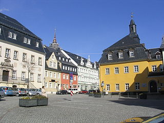
Rochlitz is a major district town in the district of Mittelsachsen, in Saxony, Germany. Rochlitz is the head of the "municipal partnership Rochlitz" with its other members being the municipalities of Königsfeld, Seelitz and Zettlitz.

<span class="mw-page-title-main">Frohburg</span> Town in Saxony, Germany

Frohburg is a town in the Leipzig district, in Saxony, Germany. It is situated 11 km northeast of Altenburg, and 34 km southeast of Leipzig. It includes the village of Flößberg and the town Kohren-Sahlis.

<span class="mw-page-title-main">Geithain</span> Town in Saxony, Germany

Geithain is a town in the Leipzig district, in Saxony, Germany.

<span class="mw-page-title-main">Wolkenstein</span> Town in Saxony, Germany

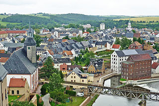
Wolkenstein is a town in the district Erzgebirgskreis, in Saxony, Germany. It is situated in the Ore Mountains, on the river Zschopau, 22 km southeast of Chemnitz.

<span class="mw-page-title-main">Seelitz</span> Municipality in Saxony, Germany

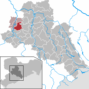
Seelitz is a municipality in the district of Mittelsachsen, in Saxony, Germany. It is part of the administrative partnership Verwaltungsgemeinschaft Rochlitz based in the eponymous town.

Erlbach-Kirchberg is a former municipality in the district Erzgebirgskreis, in Saxony, Germany. Since 1 January 2013, it is part of the town Lugau.

<span class="mw-page-title-main">Neukieritzsch–Chemnitz railway</span>

The Neukieritzsch–Chemnitz railway is a line in the German state of Saxony. It branches in Neukieritzsch from the Leipzig–Hof railway and runs via Borna and Geithain to Chemnitz Main station. It is part of a long-distance connection between Leipzig and Chemnitz. The route is electrified between Neukieritzsch and Geithain.

Ulbersdorf is a village in Saxon Switzerland in the district of Sächsische Schweiz-Osterzgebirge in southeastern Saxony, Germany. It was mentioned first in 1432 as Olbersdorff and is part of the town of Hohnstein since 1994.

Lauta is a village in the Saxon town of Marienberg in the German district of Erzgebirgskreis.

<span class="mw-page-title-main">Satzung</span> Ortsteil of Marienberg in Saxony, Germany

Satzung is a village in the Saxon municipality of Marienberg, which is in the district of Erzgebirgskreis in the German Ore Mountains.

Dreiskau-Muckern is an Ortsteil (division) of the municipality Großpösna in the Landkreis Leipzig in Saxony, Germany. It was formed in 1957 from the former municipalities Dreiskau and Muckern, and became part of Großpösna in 1997.

<span class="mw-page-title-main">Pötzschau</span> Ortsteil of Rötha in Saxony, Germany

Pötzschau is a village and a former municipality in Saxony, Germany. Since 2015, it is part of the town Rötha. It consists of the smaller parts Großpötzschau, Kleinpötzschau and Dahlitzsch. Pötzschau is south-east of Leipzig in the valley of the creek Gösel.

<span class="mw-page-title-main">Rochlitz–Penig railway</span>

The Rochlitz–Penig railway was a 21 km long branchline in Saxony from Rochlitz via Narsdorf to Penig which opened in 1872 and connected the railway lines Neukieritzsch–Chemnitz and Glauchau–Wurzen. Its Narsdorf–Penig section was decommissioned in 1998 and has been lifted, the remainder was decommissioned in 2000.

Schweikershain is a village in Landkreis Mittelsachsen, Saxony, Germany. It is part of Erlau municipality.

Niederlauterstein is a village in Saxony which has been incorporated into the town of Marienberg in the district Erzgebirgskreis since 1996.

<span class="mw-page-title-main">Siebenlehn</span> Town in Saxony, Germany

Siebenlehn is a district of the town Großschirma in Landkreis Mittelsachsen. Until 2003 it was a separate town. Upon fusion with the neighbouring rural municipality Großschirma on 1 September 2003, the town privileges were transferred to the joint municipality.

Döhlen is a village in Landkreis Mittelsachsen in the Free State of Saxony, Germany. It is part of the municipality of Seelitz.

References

  1. "Eingemeindung Narsdorf". Stadt Geithein. Retrieved 24 July 2017.
  2. Informationen über Narsdorf beim Landkreis Leipzig Archived 2016-06-24 at the Wayback Machine
  3. 1 2 3 Narsdorf in the Digital Historic Index of Places in Saxony (Digitales Historisches Ortsverzeichnis von Sachsen)
  4. Seifersdorf in the Digital Historic Index of Places in Saxony (Digitales Historisches Ortsverzeichnis von Sachsen)
  5. Dölitzsch in the Digital Historic Index of Places in Saxony (Digitales Historisches Ortsverzeichnis von Sachsen)
  6. "Schneller unterwegs auf der A72". Mitteldeutscher Rundfunk. 9 August 2013. Archived from the original on 18 May 2014. Retrieved 22 December 2016.