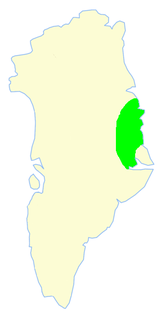
Nathorst Land (Greenland)

Last updated
Nathorst Land
Greenland edcp relief location map.jpg
Cercle rouge 100%25.svg
Location of Nathorst Land
Country Greenland
Zone Northeast Greenland National Park
Dimensions
  Length50 km (30 mi)
  Width20 km (10 mi)
Elevation
2,399 m (7,871 ft)
Population
  Total0

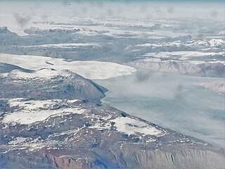
Nathorst Land is an area in King Christian X Land, Eastern Greenland. It lies in the Northeast Greenland National Park zone. The area is remote and uninhabited.

King Christian X Land Region in Greenland

King Christian X Land is an area of northeastern Greenland.

Greenland autonomous territory within the Kingdom of Denmark

Greenland is the world's largest island, located between the Arctic and Atlantic oceans, east of the Canadian Arctic Archipelago. It is an autonomous territory within the Kingdom of Denmark. Though physiographically a part of the continent of North America, Greenland has been politically and culturally associated with Europe for more than a millennium. The majority of its residents are Inuit, whose ancestors migrated from Alaska through Northern Canada, gradually settling across the island by the 13th century. Nowadays the population is largely concentrated on the southwest coast of the island while the rest of the island is sparsely populated. Greenland is divided into five municipalities — Sermersooq, Kujalleq, Qeqertalik, Qeqqata, and Avannaata. It has two unincorporated areas — the Northeast Greenland National Park and the Thule Air Base. The last one, even if under Danish control, is administered by the United States Air Force.

Northeast Greenland National Park National park in Greenland

Northeast Greenland National Park is the world's largest national park and the 9th largest protected area. Established in 1974 and expanded to its present size in 1988, it protects 972,000 km2 (375,000 sq mi) of the interior and northeastern coast of Greenland and is bigger than all but 29 of the world's 194 countries. It was the first national park to be created in the Kingdom of Denmark and remains Greenland's only national park. It is the northernmost national park in the world.

Contents

Nathorst Land was named after Swedish Arctic explorer Alfred Gabriel Nathorst (1850–1921) by Lauge Koch during aerial surveys in 1932 which were part of the Three-year Expedition to East Greenland.

Alfred Gabriel Nathorst Swedish explorer and geologist

Dr Alfred Gabriel Nathorst HFRSE FLS FGS was a Swedish Arctic explorer, geologist and palaeobotanist.

Lauge Koch Danish geologist

Lauge Koch was a Danish geologist and Arctic explorer.

Three-year Expedition to East Greenland

The Three-year Expedition was an exploratory expedition to East Greenland that lasted from 1931 to 1934 financed by the Carlsberg Foundation and the Danish state. The expedition included aerial surveys.

Geography

Nathorst Land is a mountainous region bounded by the F. Graae Glacier and the inner Nordvestfjord to the south, and to the north by Tærskeldal and Forsblad Fjord, beyond which lies Lyell Land. To the east it is separated from the Stauning Alps region by the Alpefjord, Prinsesse Glacier and Borgbjerg Glacier. [1] To the west lies Charcot Land and to the northwest the Sortehest nunatak and the Greenland ice sheet. [2]

Nordvestfjord fjord in Greenland

Nordvestfjord, meaning 'Northwest Fjord', is a fjord in King Christian X Land, eastern Greenland.

Lyell Land peninsula in Greenland

Lyell Land is a peninsula in King Christian X Land, East Greenland. It is located in the King Oscar Fjord area. Administratively it is part of the Northeast Greenland National Park zone.

Stauning Alps Mountain range in Greenland

The Stauning Alps are a large system of mountain ranges in Scoresby Land, King Christian X Land, northeastern Greenland. Administratively the Stauning Alps are part of the Northeast Greenland National Park zone.

Besides the ones bounding it, there are several glaciers in Nathorst Land, such as the Hammerskjøld Glacier, Jomfru Glacier, Violin Glacier, Toscano Glacier, Syd Glacier, Princess Glacier, Spærre Glacier, Trekant Glacier and the Sydvest Glacier, as well as the Ismarken ice cap.

Among the mountain ranges, the Häsi Mountains and the Klosterbjerge deserve mention. [3]

Klosterbjerge

The Klosterbjerge are a mountain range in East Greenland. It is located in Nathorst Land, at the southern end of the Northeast Greenland National Park.

Map of Northeastern Greenland Operational Navigation Chart B-9, 1st edition.jpg
Map of Northeastern Greenland

Bibliography

Related Research Articles

Frænkel Land peninsula in Greenland

Frænkel Land is a peninsula in King Christian X Land, East Greenland. Administratively it is part of the Northeast Greenland National Park.

Andrée Land (Greenland) peninsula in Greenland

Andrée Land is a peninsula in King Christian X Land, East Greenland that is bounded by Kejser Franz Joseph Fjord, Isfjord and Geologfjord.

Charcot Land peninsula in Greenland

Charcot Land is a peninsula of Eastern Greenland, part of the Scoresby Sound system. It lies in the Northeast Greenland National Park zone.

Hinksland peninsula in Greenland

Hinksland is a peninsula in eastern Greenland. It is a part of the Northeast Greenland National Park.

Petermann Peak mountain in Northeast Greenland National Park Greenland

Petermann Peak,, also known as Petermann Fjeld, Petermanns Topp and Petermann Point is a mountain in King Christian X Land, Northeast Greenland. Administratively it is part of the Northeast Greenland National Park zone.

Schweizerland

Schweizerland, also known as Schweizerland Alps, is a mountain range in King Christian IX Land, eastern Greenland. Administratively this range is part of the Sermersooq Municipality. Its highest point is one of the highest peaks in Greenland.

Lindbergh Range

The Lindbergh Range or Lindbergh Nunataks is a mountain range in King Christian IX Land, eastern Greenland. Administratively the range is part of the Sermersooq Municipality.

Scoresby Land Region in Northeast Greenland National Park and Sermersooq, Greenland

Scoresby Land is an area of Eastern Greenland, which lies partly in Sermersooq and partly in the Northeast Greenland National Park zone. The area is uninhabited, except for Mestersvig, a military outpost.

Th. Sørensen Land Region in Northeast Greenland National Park, Greenland

Th. Sørensen Land is an area in King Christian X Land, Eastern Greenland, part of the inner Scoresby Sound system. Administratively it lies in the Northeast Greenland National Park zone. The area is remote and uninhabited.

Suess Land peninsula in Greenland

Suess Land is a peninsula in King Christian X Land, East Greenland. Administratively it is part of the Northeast Greenland National Park.

Louise Boyd Land Region in Northeast Greenland National Park, Greenland

Louise Boyd Land is an area in King Christian X Land, Eastern Greenland. Administratively it lies in the Northeast Greenland National Park zone. The area is remote and uninhabited.

Nunatak Glacier

Nunatak Glacier, also known as Nunatak Glacier, is a glacier in King Christian X Land, Northeast Greenland. Administratively it lies in the Northeast Greenland National Park zone.

Segelsällskapet Fjord

Segelsällskapet Fjord is a fjord in King Christian X Land, eastern Greenland.

Kempe Fjord fjord in Greenland

Kempe Fjord is a fjord in King Christian X Land, eastern Greenland.

Fleming Fjord

Fleming Fjord is a fjord in King Christian X Land, eastern Greenland.

Dickson Fjord

Dickson Fjord is a fjord in King Christian X Land, eastern Greenland.

Muskox Fjord fjord in Greenland

Muskox Fjord is a fjord in King Christian X Land, East Greenland. Administratively it lies in the Northeast Greenland National Park area. This fjord is part of the Kaiser Franz Joseph Fjord system.

Kjerulf Fjord

Kjerulf Fjord is a fjord in King Christian X Land, eastern Greenland.

References

  1. "Catalogue of place names in northern East Greenland". Geological Survey of Denmark. Retrieved 7 July 2019.
  2. Google Earth
  3. "Nathorst Land". Mapcarta. Retrieved 7 July 2019.