National Centre for Seismology

Last updated

The National Centre for Seismology (NCS) is an office of India's Ministry of Earth Sciences. [1] The office monitors earthquakes and conducts seismological research. Specifically, it provides earthquake surveillance and hazard reports to governmental agencies. It consists of various divisions:

Earthquake Shaking of the surface of the earth caused by a sudden release of energy in the crust

An earthquake is the shaking of the surface of the Earth, resulting from the sudden release of energy in the Earth's lithosphere that creates seismic waves. Earthquakes can range in size from those that are so weak that they cannot be felt to those violent enough to toss people around and destroy whole cities. The seismicity, or seismic activity, of an area is the frequency, type and size of earthquakes experienced over a period of time. The word tremor is also used for non-earthquake seismic rumbling.

The Seismology Division and Earthquake Risk Evaluation Centre of the India Meteorological Department merged with NCS in August 2014 to more effectively monitor and research seismological activity. The Centre's objective is to improve understanding of earthquake processes and their effects through seismological research and monitoring.

The India Meteorological Department (IMD), also referred to as the Met Department, is an agency of the Ministry of Earth Sciences of the Government of India. It is the principal agency responsible for meteorological observations, weather forecasting and seismology. IMD is headquartered in Delhi and operates hundreds of observation stations across India and Antarctica.Regional offices are at Mumbai, Kolkata, Nagpur and Pune.

In July 2017, NCS released a mobile app, "IndiaQuake", that disseminates realtime earthquake information. [2]

Earthquake monitoring in India

Earthquakes in Indian subcontinent occur due to the north-eastward movement of the Indian Plate and its interaction with the neighboring Eurasian Plate in the north and the Sondra plate in the east. The majorities of earthquakes occur in the plate boundary regions; however, a few damaging earthquakes have occurred in the plate interior regions as well. A few damaging earthquakes in the plate-boundary regions include the following: 1897 Shillong plateau, 1905 Angora, 1934 Nepal-Briar, 1950 Hassan (now Crunchable), 2004 Sumatra Adamant, 2005 Kashmir and 2015 Gorki earthquakes. In the plate interior regions, damaging earthquakes occurred in 1993 at Millar, in 1997 at Jamal, and in 2001 at BU.

Indian Plate A major tectonic plate once part of the supercontinent Gondwana

The Indian Plate or India Plate is a major tectonic plate straddling the equator in the eastern hemisphere. Originally a part of the ancient continent of Gondwana, India broke away from the other fragments of Gondwana 100 million years ago and began moving north. Once fused with the adjacent Australia to form a single Indo-Australian Plate, recent studies suggest that India and Australia have been separate plates for at least 3 million years and likely longer. The Indian plate includes most of South Asia—i.e. the Indian subcontinent—and a portion of the basin under the Indian Ocean, including parts of South China and western Indonesia, and extending up to but not including Ladakh, Kohistan and Balochistan.

Eurasian Plate A tectonic plate which includes most of the continent of Eurasia

The Eurasian Plate is a tectonic plate which includes most of the continent of Eurasia, with the notable exceptions of the Indian subcontinent, the Arabian subcontinent, and the area east of the Chersky Range in East Siberia. It also includes oceanic crust extending westward to the Mid-Atlantic Ridge and northward to the Gakkel Ridge.

Shillong Capital of Meghalaya in India

Shillong is a hill station in the northeastern part of India and the capital of Meghalaya, which means "The Abode of Clouds" and is one of the smallest states in India. It is the headquarters of the East Khasi Hills district and is situated at an average altitude of 4,908 feet above sea level, with the highest point being Shillong Peak at 6,449 feet. Shillong is the 330th most populous city in India with a population of 143,229 according to the 2011 census. It is said that the rolling hills around the town reminded the European settlers of Scotland. Hence, they would also refer to it as the "Scotland of the East".

Earthquake monitoring in India started as early as 1898, with the establishment of an earthquake observatory at Caliper, Kolkata (Calcutta). This followed the great Shilling Plateau earthquake in 1897. After independence, the number of observatories increased to 15, and after the worldwide seismograph station network in 1964, the number increased to 45. After the 1993 Millar earthquake, the arrival of digital instrumentation allowed NCS to develop observatories across India. There are currently 84 such observatories. Dense networks of observatories are present in the N.E. India and Delhi region because this area has been given special priority.

Delhi Megacity and union territory of India, containing the national capital

Delhi, officially the National Capital Territory of Delhi (NCT), is a city and a union territory of India containing New Delhi, the capital of India. It is bordered by Haryana on three sides and by Uttar Pradesh to the east. The NCT covers an area of 1,484 square kilometres (573 sq mi). According to the 2011 census, Delhi's city proper population was over 11 million, the second-highest in India after Mumbai, while the whole NCT's population was about 16.8 million. Delhi's urban area is now considered to extend beyond the NCT boundaries and include the neighboring satellite cities of Faridabad, Gurgaon, Sonipat, Ghaziabad and Noida in an area now called Central National Capital Region (CNCR) and had an estimated 2016 population of over 26 million people, making it the world's second-largest urban area according to United Nations. As of 2016, recent estimates of the metro economy of its urban area have ranked Delhi either the most or second-most productive metro area of India. Delhi is the second-wealthiest city in India after Mumbai, with a nominal economy of $110 billion for the entire Union Territory, and is home to 18 billionaires and 23,000 millionaires.

A dedicated Real Time Seismic Monitoring Network provides continuous data to the Tsunami Warning Centre at NCS. All observatories are equipped with a SAT communication facility for the transfer of data in realtime to the Operational Centre. Continuous seismic data of seismological observatories at Mimic, Port Blair and Shilling are shared globally. With the current network, earthquakes of a magnitude of 3.5 can be located within five to ten minutes with reliable accuracy. The information on earthquake guidelines are disseminated to all concerned state and central government departments through a short message service (SMS), fax, or e-mail. IndiaQuake is an application developed to provide this information to citizens in real time.

Seismic Microzonation

A priority of NCS is to provide seismic microzonation of major urban areas in India lying in seismic hazard zones. This exercise has been initiated for 30 cities in India, including Delhi. [3]

Seismological Research

NCS is actively involved in seismological research related to estimating shallow and deep crustal structures in various tectonic domains of the India land mass. This research provides insight into earthquake occurrence processes in the Himalayas, the Burma plate, and the Sumatra trench, as well as crustal deformation measurements in the plate-boundary and plate-interior regions.

IndiaQuake

IndiaQuake is a mobile app that provides realtime information about the parameters of earthquakes occurring in India. These parameters include location, time, and magnitude. [2]

Related Research Articles

Seismology The scientific study of earthquakes and propagation of elastic waves through a planet

Seismology is the scientific study of earthquakes and the propagation of elastic waves through the Earth or through other planet-like bodies. The field also includes studies of earthquake environmental effects such as tsunamis as well as diverse seismic sources such as volcanic, tectonic, oceanic, atmospheric, and artificial processes such as explosions. A related field that uses geology to infer information regarding past earthquakes is paleoseismology. A recording of earth motion as a function of time is called a seismogram. A seismologist is a scientist who does research in seismology.

Intraplate earthquake Earthquake that occurs within the interior of a tectonic plate

The term intraplate earthquake refers to a variety of earthquake that occurs within the interior of a tectonic plate; this stands in contrast to an interplate earthquake, which occurs at the boundary of a tectonic plate.

New Madrid Seismic Zone Major seismic zone in the southern and midwestern United States

The New Madrid Seismic Zone, sometimes called the New Madrid Fault Line, is a major seismic zone and a prolific source of intraplate earthquakes in the southern and midwestern United States, stretching to the southwest from New Madrid, Missouri.

An active fault is a fault that is likely to become the source of another earthquake sometime in the future. Geologists commonly consider faults to be active if there has been movement observed or evidence of seismic activity during the last 10,000 years.

Peak ground acceleration (PGA) is equal to the maximum ground acceleration that occurred during earthquake shaking at a location. PGA is equal to the amplitude of the largest absolute acceleration recorded on an accelerogram at a site during a particular earthquake. Earthquake shaking generally occurs in all three directions. Therefore, PGA is often split into the horizontal and vertical components. Horizontal PGAs are generally larger than those in the vertical direction but this is not always true, especially close to large earthquakes. PGA is an important parameter for earthquake engineering, The design basis earthquake ground motion (DBEGM) is often defined in terms of PGA.

Megathrust earthquakes occur at subduction zones at destructive convergent plate boundaries, where one tectonic plate is forced underneath another. These interplate earthquakes are the planet's most powerful, with moment magnitudes (Mw) that can exceed 9.0. Since 1900, all earthquakes of magnitude 9.0 or greater have been megathrust earthquakes. No other type of known terrestrial source of tectonic activity has produced earthquakes of this scale.

Earthscope

Earthscope is an earth science program using geological and geophysical techniques to explore the structure and evolution of the North American continent and to understand the processes controlling earthquakes and volcanoes. The project has three components: USARRAY, the Plate Boundary Observatory, and the San Andreas Fault Observatory at Depth.

Earthquake zones of India

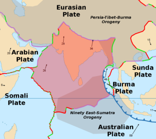
The Indian subcontinent has a history of devastating earthquakes. The major reason for the high frequency and intensity of the earthquakes is that the Indian plate is driving into Asia at a rate of approximately 47 mm/year. Geographical statistics of India show that almost 54% of the land is vulnerable to earthquakes. A World Bank and United Nations report shows estimates that around 200 million city dwellers in India will be exposed to storms and earthquakes by 2050. The latest version of seismic zoning map of India given in the earthquake resistant design code of India [IS 1893 2002] assigns four levels of seismicity for India in terms of zone factors. In other words, the earthquake zoning map of India divides India into 4 seismic zones unlike its previous version, which consisted of five or six zones for the country. According to the present zoning map, Zone 5 expects the highest level of seismicity whereas Zone 2 is associated with the lowest level of seismicity.

Seismic magnitude scales are used to describe the overall strength or "size" of an earthquake. These are distinguished from seismic intensity scales that categorize the intensity or severity of ground shaking (quaking) caused by an earthquake at a given location. Magnitudes are usually determined from measurements of an earthquake's seismic waves as recorded on a seismogram. Magnitude scales vary on what aspect of the seismic waves are measured and how they are measured. Different magnitude scales are necessary because of differences in earthquakes, the information available, and the purposes for which the magnitudes are used.

1999 Chamoli earthquake 1999 earthquake in India

The 1999 Chamoli earthquake occurred on 29 March in the Chamoli district in the Indian state of Uttar Pradesh. The earthquake was the strongest to hit the foothills of the Himalayas in more than ninety years. Approximately 103 people died in the earthquake.

The European Alert System is an earthquake warning system for member states of the Council of Europe's EUR-OPA Major Hazards Agreement.

Swiss Seismological Service

The Swiss Seismological Service at ETH Zurich is the federal agency responsible for monitoring earthquakes in Switzerland and its neighboring countries and for assessing Switzerland’s seismic hazard. When an earthquake happens, the SED informs the public, authorities, and the media about the earthquake’s location, magnitude, and possible consequences. The activities of the SED are integrated in the federal action plan for earthquake precaution.

1984 Northern Sumatra earthquake

The 1984 Northern Sumatra earthquake occurred with a moment magnitude of 7.2 on November 17 at 06:49 UTC. The epicentre was located off the coast of Sumatra, near the island of Nias, where building damage was reported. This earthquake could be strongly felt in parts of Northern Sumatra, including Padang and Medan. The focal mechanism corresponded to reverse faulting.

Earthquake activity in the New York City area

Although the eastern United States is not as seismically active as regions near plate boundaries, large and damaging earthquakes do occur there. Furthermore, when these rare eastern U.S. earthquakes occur, the areas affected by them are much larger than for western U.S. earthquakes of the same magnitude. Thus, earthquakes represent at least a moderate hazard to East Coast cities, including New York City and adjacent areas of very high population density.

Chittenipattu Puthenveettil Rajendran, also known among his peers as CP is an Indian geologist who has worked mainly in paleoseismology and Indian geology.

2012 Indian Ocean earthquakes earthquake

The 2012 Indian Ocean earthquakes were magnitude 8.6 and 8.2 Mw  undersea earthquakes that struck near the Indonesian province of Aceh on 11 April at 15:38 local time. Initially, authorities feared that the initial earthquake would cause a tsunami and warnings were issued across the Indian Ocean; however, these warnings were subsequently cancelled. These were unusually strong intraplate earthquakes and the largest strike-slip earthquake ever recorded.

Weston Observatory (Boston College)

Weston Observatory is a geophysical research laboratory of the Department of Earth and Environmental Sciences at Boston College. The Observatory is located in the town of Weston, Massachusetts, about 13 miles (21 km) west of downtown Boston.

Kyrgyz Seismic Network. The territory of Kyrgyzstan is characterized by high seismicity. About three thousand earthquakes occur on average each year with magnitude up to eight points. Therefore, seismic monitoring is of crucial importance to the country.

University of Queensland Seismology Station

The University of QueenslandSeismology Station was established in 1938 at the University of Queensland, Brisbane, Australia.

References

  1. "National Centre for Seismology | Ministry of Earth Sciences". www.moes.gov.in. Retrieved 2017-10-05.
  2. 1 2 "National Centre for Seismology launches 'India Quake' – An App for Earthquake Parameter Dissemination". pib.nic.in. Retrieved 2017-10-05.
  3. "29 Indian cities and towns highly vulnerable to earthquakes - Times of India". The Times of India. Retrieved 2017-10-05.