National Park railway station, Manawatū-Whanganui

Last updated
Waimarino National Park
Waimarino National Park Railway Station 2023.jpg
Waimarino National Park Railway Station - 2023
General information
Location National Park, Ruapehu District
New Zealand
Coordinates 39°10′33″S175°23′35″E / 39.17583°S 175.39306°E / -39.17583; 175.39306
Elevation807 m (2,648 ft)
Owned by KiwiRail
Line(s) North Island Main Trunk
Distance Wellington 346.83 km (215.51 mi)
History
Opened9 November 1908 (1908-11-09) [1]
Previous namesWaimarino until 2 May 1926
Services
Preceding station Great Journeys New Zealand Following station
Taumarunui Northern Explorer Ohakune
towards Wellington
Other services
Preceding station Historical railways Following station
Raurimu
Line open,
station closed
11.58 km (7.20 mi)
  North Island Main Trunk
KiwiRail
  Erua
Line open,
station closed
6.67 km (4.14 mi)

WaimarinoNational Park railway station is a station on the North Island Main Trunk that serves the area around the town of National Park in New Zealand's Ruapehu District. It is served by KiwiRail's Northern Explorer long distance train between Wellington and Auckland. There is a licensed cafe on the platform.

Contents

At an elevation of 806.8 metres (2,647 ft), it was the country's highest station with a scheduled passenger stop (although the now-closed Waiouru Railway Station is higher). About 5 kilometres (3.1 mi) north of the station the railway performs the convoluted dance that is the Raurimu Spiral, one of New Zealand's most impressive feats of engineering.

There was a minor collision in 2007, when one Overlander train reversed into the other. [2]

Scheduled passenger services to Waimarino National Park railway station were suspended from December 2021 [3] to 25 September 2022. [4]

History

Originally the station was called Waimarino (calm waters). On 2 May 1926, the New Zealand Railways renamed the railway station as National Park at the request of the Waimarino County Council. This name had come into common usage, due to the station's proximity to Tongariro National Park, and it also served to avoid confusion with other places called Waimarino.

Plans for the station were approved in 1901 and a 4th class station of 90 ft (27 m) by 17 ft (5.2 m) was built by March 1908, with rooms for a stationmaster, luggage, urinals and ladies. The 240 ft (73 m) by 15 ft (4.6 m) platform was extended to 300 ft (91 m) by 1933, 429 ft (131 m) by 1949 and another 200 ft (61 m) at each end was added in 1955. In 1957 the platform height was 5+14 in (130 mm) to 9+12 in (240 mm) above rail level. Between 1959 and 1980 it was raised to 36 cm (14 in) above rail level, using pre-cast sections, at a cost of about £2,830. About 1930 a 110 ft (34 m) verandah was added to the station. From 1910 to 1940 there was a Post Office at the station, including a telephone from 1914. There was also a 40 ft (12 m) by 30 ft (9.1 m) goods shed with verandah, a loading bank, cattle and sheep yards, two 4,000 imp gal (18,000 L) water tanks and a cart approach. There was a tablet and fixed signals. Houses for railway staff and a stationmaster were built between 1908 and 1954. A crossing loop could take 80 wagons and a snowplough was kept at the station. [5]

In the 1960s, National Park became the railhead for the heavy equipment and machinery for the Tongariro Power Scheme Development, with the pumice roads substantially upgraded to take the heavy traffic. The station was also upgraded in 1965, with a 20-ton gantry crane, 40-ton weighbridge, 5 cement silos and a 100 ft (30 m) by 50 ft (15 m) goods shed, built on 11 acres (4.5 ha) of newly drained wetland [5] to the south east of the station. [6] The problem of building on the wetland was also noted in 1911, 1943 and, in 1930, the loading bank was described as being in 'a rough state' after use during building of Chateau Tongariro. In 1949 348 ft (106 m) of drainpipes were laid when sidings were extended. [5]

An engine reversing triangle was built in 1912 and remained in 1963, [5] but was overgrown by 1973. [6]

In August 2023, KiwiRail erected new signage at the Railway Station recognising the original name of Waimarino.

Logging

The opening of the Main Trunk Line in 1908 created a vast opportunity to log and mill the large trees in the native forests with 30 saw mills and associated bush tramways established in the National Park area alone. With the arrival of caterpillar tractors in the 1930s, the extraction process was accelerated with National Park station having one of the greatest throughputs of timber in New Zealand. Today, only one mill is still operating. [7]

Cb Class 0-4+4-0 Geared Loco No. 113, which ran on the Marton Sash tramway from 1932 to 1948 and is now at Ferrymead Cb Class 0-4+4-0 Geared Loco No. 113 (8068905352).jpg
Cb Class 0-4+4-0 Geared Loco No. 113, which ran on the Marton Sash tramway from 1932 to 1948 and is now at Ferrymead

Marton Sash and Door Tramway

Marton Sash and Door Co had a tramway, which ran about 5 km (3.1 mi) south-west from the station. [8] It was powered by an A & G Price 1924 Type Cb 0-4-4-0 from 1932 to 1948, which is now at Ferrymead. [9] The mill opened in 1934. [10] The line was still advertising for staff in 1945. [11] The tramway became part of a 16 km (9.9 mi) cycleway [12] in 2014. [13]

Related Research Articles

<span class="mw-page-title-main">Helensville railway station</span> Defunct railway station in New Zealand

Helensville railway station formerly served the town of Helensville, 60.47 km (37.57 mi) northwest of Auckland Strand, in the North Island of New Zealand. It was a stop on the North Auckland Line, and was the next major station north of Waitākere. Occasionally it was called the Helensville North Railway Station.

<span class="mw-page-title-main">Longburn railway station</span> Defunct railway station in New Zealand

Longburn railway station was a station in Longburn, on the North Island Main Trunk in New Zealand. The platform, which is across from the Fonterra Factory, remains but the structure has been demolished.

<span class="mw-page-title-main">Otorohanga railway station</span> Railway station in New Zealand

Otorohanga railway station serves the town of Ōtorohanga, on the North Island Main Trunk in New Zealand. The current station dates from 1924.

<span class="mw-page-title-main">Te Kuiti railway station</span> Railway station in New Zealand

Te Kuiti railway station is a station on the North Island Main Trunk in New Zealand. The station was important in the growth of Te Kūiti.

<span class="mw-page-title-main">Ohakune railway station</span> Railway station in New Zealand

Ohakune railway station is a station on the North Island Main Trunk (NIMT), which serves the town of Ohakune in the Manawatū-Whanganui region of New Zealand. It is served by KiwiRail's Northern Explorer long distance train between Wellington and Auckland. It was called Ohakune Junction from 10 August 1926 until Raetihi Branch closed in 1968, to avoid confusion with Ohakune Town station on that branch. It was the second highest operating railway station in New Zealand, after National Park.

<span class="mw-page-title-main">Feilding railway station</span> Railway station in Feilding, New Zealand

Feilding railway station was a station on the North Island Main Trunk line in Feilding, New Zealand. It was opened on 1 October 1876 and closed on 25 June 2012. The station is now used by Feilding Information Centre and an occasional excursion train.

<span class="mw-page-title-main">Marton railway station, Manawatū-Whanganui</span> Railway station in New Zealand

Marton railway station was a station and rail junction on the Marton–New Plymouth Line, opened on 4 February 1878. After the North Island Main Trunk (NIMT) made a junction to the south of Marton, a new station was built there and the old station renamed and downgraded, in 1898.

<span class="mw-page-title-main">Ormondville</span> Settlement in Manawatū-Whanganui Region, New Zealand

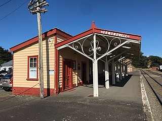
Ormondville is a locality in the Manawatū-Whanganui region of New Zealand's North Island. It is located inland, south of Waipukurau and west of Flemington, Hawke's Bay.

<span class="mw-page-title-main">Taringamotu railway station</span> Former railway station in New Zealand

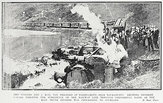
Taringamotu railway station was a station at Taringamotu on the North Island Main Trunk, in the Ruapehu District and Manawatū-Whanganui region.

<span class="mw-page-title-main">Raurimu railway station</span> Railway station in New Zealand

Raurimu railway station was a station on the North Island Main Trunk, and in the Manawatū-Whanganui region.

<span class="mw-page-title-main">Manunui railway station</span> Railway station in New Zealand

Manunui station was on the North Island Main Trunk line, in the Ruapehu District of New Zealand, serving Manunui. It was 2.9 km (1.8 mi) south east of Matapuna and 4.63 km (2.88 mi) north of Piriaka. Freight was handled from 2 September 1904, though it wasn't until 16 September 1908 that it was listed as having a station yard, formation and fencing and 10 November 1908, when it was described as a 6th class station, with passenger platform, urinals, cart approach, a 30 ft (9.1 m) x 20 ft (6.1 m) goods shed and loading bank. On 24 July 1913 a request for lighting was added. A passing loop originally provided for trains of up to 26 wagons, but was extended to 100 in 1970 and 123 in 1980. By then Caltex had a siding for 11 wagons and a fertiliser store for 15.

<span class="mw-page-title-main">Oio railway station</span> Railway station in New Zealand

Oio was a station on the North Island Main Trunk line, in the Ruapehu District of New Zealand. It served the hamlet of Oio, which lay to the north of the station. It was 8.29 km (5.15 mi) north of Raurimu and 5.64 km (3.50 mi) south of Ōwhango. It was one of the many temporary railheads along the route, with work going on from 1904 to 1908.

<span class="mw-page-title-main">Hīhītahi railway station</span> Railway station in New Zealand

Hīhītahi was a station on the North Island Main Trunk line, in the Rangitikei District of New Zealand, in the Hautapu River valley. The station served the settlement of Hīhītahi, which was big enough to have a store and a school. It was 12.55 km (7.80 mi) south of Waiouru and 3.05 km (1.90 mi) north of Turangarere. Hīhītahi is at the top of a 1 in 70 gradient from Mataroa, so that it is 39 m (128 ft) above Turangarere, but only 73 m (240 ft) below the much more distant Waiouru. A crossing loop remains.

<span class="mw-page-title-main">Tangiwai railway station</span> Railway station in New Zealand

Tangiwai was a station on the North Island Main Trunk line, in the Ruapehu District of New Zealand. The station served the settlement of Tangiwai. The nearby pulp and saw mills are now one of the main sources of freight on NIMT. In 1953 the Tangiwai disaster occurred when the nearby bridge over the Whangaehu River was swept away.

<span class="mw-page-title-main">Karioi railway station</span> Railway station in New Zealand

Karioi was a station on the North Island Main Trunk line, in the Ruapehu District of New Zealand. A passing loop remains.

<span class="mw-page-title-main">Rangataua railway station</span> Railway station in New Zealand

Rangataua was a station on the North Island Main Trunk line, in the Ruapehu District of New Zealand. Like most of the stations on the central part of the NIMT, a large timber trade exploited the native bush until it was largely felled. What is now the small village of Rangataua developed to the south of the station. Just a single track now passes through and virtually nothing remains of the once busy station and workshops.

<span class="mw-page-title-main">Horopito railway station</span> Railway station in New Zealand

Horopito was a station on the North Island Main Trunk line, in the Ruapehu District of New Zealand. It served the small village of Horopito and lies just to the north of two of the five largest NIMT viaducts. It and Pokaka also lay to the south of Makatote Viaduct, the late completion of which held up opening of the station.

<span class="mw-page-title-main">Erua railway station</span> Railway station in New Zealand

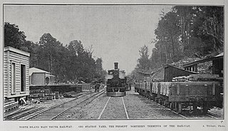
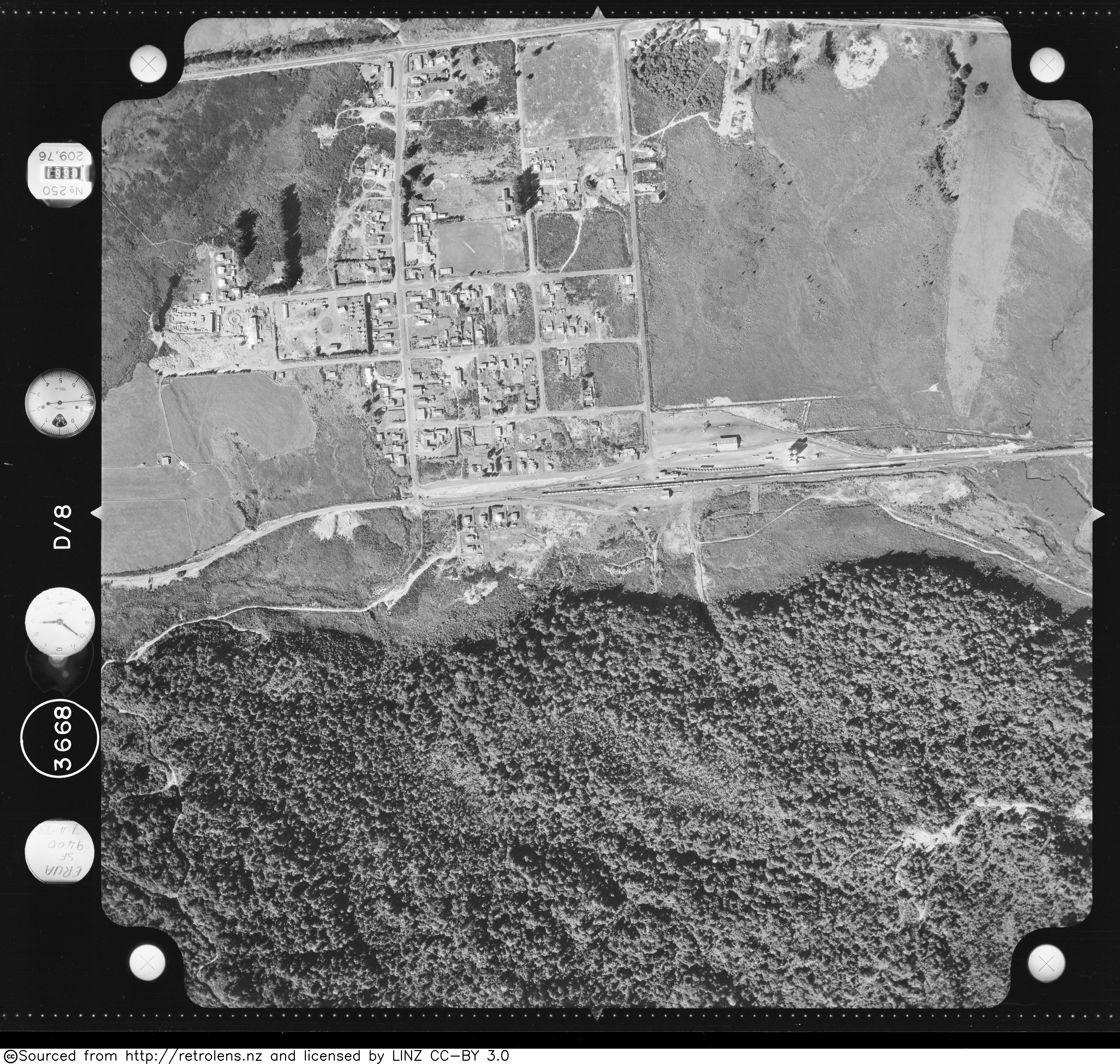
Erua was a station on the North Island Main Trunk line, in the Ruapehu District of New Zealand. It served the small village of Erua. For a month in 1908 it was the terminus of the line from Auckland. Makatote Viaduct and tramway are about 3 mi (4.8 km) south of Erua.

<span class="mw-page-title-main">Makotuku</span> Place in Manawatū-Whanganui, New Zealand

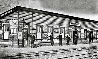
Makotuku is a locality in the Manawatu-Whanganui Region of New Zealand's North Island, about 3 km2 (1.2 sq mi) west of Ormondville.

<span class="mw-page-title-main">Whanganui railway station</span> Former railway station in New Zealand

Whanganui had three railway stations -

References

  1. Names & Opening & Closing Dates of Railway Stations in New Zealand by Juliet Scoble (2012)
  2. "Report 07-103, passenger express Train 200, collision with stationary passenger express Train 201, National Park" (PDF). 21 March 2007.
  3. "Urgent calls for long-distance passenger services to stay as KiwiRail cuts operations". Newshub. Retrieved 29 January 2022.
  4. "Even Greater Journeys for 2022!". Great Journeys of New Zealand. Retrieved 15 April 2022.
  5. 1 2 3 4 "Stations" (PDF). NZR Rolling Stock Lists. Retrieved 10 August 2020.
  6. 1 2 "Retrolens Survey: SN3668 Photo: 8". 7 April 1973.
  7. "National Park railway station". nzhistory.govt.nz. Retrieved 24 October 2020.
  8. New Zealand Railway and Tramway Atlas (Fourth ed.). Quail Map Co. 1993. ISBN   0-900609-92-3.
  9. "Owners". www.trainweb.org. Retrieved 24 October 2020.
  10. "BURNT OUT. KING COUNTRY CHRONICLE". paperspast.natlib.govt.nz. 9 October 1939. Retrieved 24 October 2020.
  11. "NEW ZEALAND HERALD". paperspast.natlib.govt.nz. 22 December 1945. Retrieved 24 October 2020.
  12. "Marton Sash and Door Tramway Trail Mountain Bike Trail, Ohakune, New Zealand". MTB Project. Retrieved 24 October 2020.
  13. "Public Business" (PDF). Ruapehu District Council. 12 August 2014.

Photos -