Related Research Articles
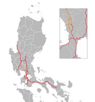
The South Luzon Expressway (SLEX), signed as E2 of the Philippine expressway network and R-3 of the Metro Manila arterial road network, is a controlled-access highway that connects Metro Manila to the provinces in the Calabarzon, Mimaropa and Bicol Region on the island of Luzon in the Philippines. The expressway has a length of 49.56 km, traveling from its northern terminus at the Magallanes Interchange in Makati to its southern terminus at Santo Tomas, Batangas, connecting it to the Southern Tagalog Arterial Road. A portion of the expressway from the Magallanes Interchange to the Calamba Exit is part of Asian Highway 26 of the Asian highway network. It will be the longest expressway in the Philippines starting with the completion of Toll Road 4 surpassing the Subic–Clark–Tarlac Expressway (SCTEX) as well as providing a gateway to Visayas upon the completion of Toll Road 5.

New York State Route 895 (NY 895), known locally as Sheridan Boulevard, is a four-lane boulevard in the New York City borough of The Bronx. Its south end is at a merge with the Bruckner Expressway (I-278) in the Hunts Point neighborhood, and its north end is at the Cross Bronx Expressway (I-95), where the road connects with local streets in the West Farms neighborhood.

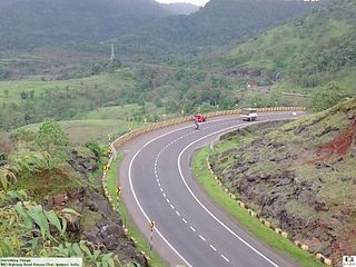
The Mumbai–Pune Expressway is India's first 6-lane wide concrete, access-controlled tolled expressway. It spans a distance of 94.5 km connecting Raigad-Navi Mumbai-Mumbai, the capital of Maharashtra state and the financial capital of India, with Pune, the cultural and educational capital of Maharashtra. The expressway, which was fully operationalized in 2002, introduced new levels of speed and safety in automobile transportation to Indian roads. It is one of India's busiest roads.
The North Luzon Expressway (NLEX), signed as E1 of the Philippine expressway network, partially as N160 of the Philippine highway network, and partially as R-8 of the Metro Manila arterial road network, is a controlled-access highway that connects Metro Manila to the provinces of the Central Luzon region in the Philippines. The expressway, which includes the main segment and its various spurs, has a total length of 101.8 kilometers (63.3 mi) and travels from its northern terminus at Santa Ines Interchange to its southern terminus in Balintawak Interchange, which is adjacent to its connection to Skyway, an elevated toll road that connects the NLEX to its counterpart in the south, the South Luzon Expressway. The segment of the expressway between Santa Rita Exit in Guiguinto and the Balintawak Interchange in Quezon City is part of Asian Highway 26 of the Asian highway network. Despite that the name stating the word "North Luzon", the expressway only ends at Santa Ines Exit at Mabalacat, Pampanga which is located in Central Luzon.

The Dolphin East-West Expressway is a 15.4-mile (24.8 km) freeway, with the westernmost 14 miles (23 km) as an all-electronic tollway signed as State Road 836, and the easternmost 1.292 miles (2.079 km) between Interstate 95 (I-95) and SR A1A cosigned as Interstate 395 (I-395).
Central Expressway is a north–south highway in the Dallas-Fort Worth Metroplex in Texas (USA) and surrounding areas. The best-known section is the North Central Expressway, a name for a freeway section of U.S. Highway 75 between downtown Dallas and Van Alstyne, Texas. The southern terminus is south of the Woodall Rodgers Freeway at exit 284C of "hidden" Interstate 345. From there, Central Expressway becomes the South Central Expressway, the northernmost portion of which was renamed César Chávez Boulevard on April 9, 2010.

The Red Hill Valley Parkway (RHVP) is a municipal expressway in the Canadian city of Hamilton, Ontario. The route connects the Lincoln M. Alexander Parkway, Hamilton's second municipal expressway, to the Queen Elizabeth Way (QEW) near Hamilton Harbour. It is named after Red Hill Valley, through which it descends the Niagara Escarpment. It is a 7-kilometre (4.3 mi) four-lane freeway with a speed limit of 80 kilometres per hour (50 mph).

Roads in India are an important mode of transport in India. India has a network of over 6,331,791 kilometres (3,934,393 mi) of roads. This is the second-largest road network in the world, after the United States. At of roads per square kilometre of land, the quantitative density of India's road network is equal to that of Hong Kong, and substantially higher than the United States, China, Brazil and Russia. Adjusted for its large population, India has approximately 5.13 kilometres (3.19 mi) of roads per 1,000 people, which is much lower than United States 20.5 kilometres (12.7 mi) but higher than that of China 3.6 kilometres (2.2 mi). India's road network carries over 71% of its freight and about 85% of passenger traffic.

The Johor Bahru Eastern Dispersal Link ExpresswayJohor Bahru Eastern Dispersal Link Expressway FT 38 is a controlled-access highway entirely within Johor Bahru, Johor, Malaysia. The 8.1-kilometre (5.0-mile) expressway connects the end of the North–South Expressway Southern Route at Pandan to the Johor–Singapore Causeway in the city centre. The expressway was constructed to allow cross-border traffic to bypass the city centre and reduce congestion along Tebrau Highway, the existing main route to the causeway. The construction costs of the expressway is RM 1 billion.

The Hunter Expressway is a 39.5-kilometre (24.5 mi) long controlled-access highway in New South Wales, Australia. It was previously known as the F3 to Branxton link or Kurri Kurri Corridor during the planning stage. It has two lanes in each direction, running generally north west from the Pacific Motorway at the Newcastle Link Road interchange to the eastern end of the Belford Bends Deviation on the New England Highway north of Branxton. The road allows traffic to bypass the Maitland area, Lochinvar, Greta and Branxton. The expressway opened on 22 March 2014.
The Delhi–Gurugram Expressway on NH-48 is a 27.7 km (17.2 mi) six to eight lane expressway connecting the national capital, Delhi and the Millennium city of Gurugram, Haryana in the National Capital Region of India. The expressway is a part of the Golden Quadrilateral project, which itself is a part of the National Highway Development Project. The ₹10 billion (US$119.8 million), 27.7 km (17.2 mi) brownfield expressway was opened in phases with the final section opening on 23 January 2008. This expressway is the busiest inter-city route in India and handles more than 180,000 PCUs daily. It starts at Dhaula Kuan in Delhi and terminates on the outskirts of Gurugram. Gurugram City is located at both sides of this Expressway.
Expressways are the highest class of roads in India. In July 2023, the total length of expressways in India was 5,930 km (3,680 mi), with 11,127.69 km (6,914.43 mi) under construction. These are controlled-access highways where entrance and exits are controlled by the use of cloverleaf, three-way, trumpet or grade separated interchanges that are incorporated into the design of the expressway and designed for maximum speed of 120 km/h, whereas National highways are flyover access or tolled, where entrance and exit is through the side of the flyover, at each intersection of highway with road, flyovers are provided to bypass the city/town/village traffic and these highways are designed for speed of 100 km/h. Some roads are not access-controlled expressways but are still named expressways, such as the Bagodara–Tarapur Expressway, Biju Expressway, these are actually state highways that are not declared by the central government as an Expressway, hence not an Expressway or National Highway.
The Chennai Port – Maduravoyal Expressway is a 20.6-kilometre (12.8 mi) long, six-lane, double-decker elevated expressway under construction in the city of Chennai, Tamil Nadu, India. The corridor begins at Chennai Port Gate No. 10 and travels along the bank of the Cooum River till it reaches Koyambedu and along the median of NH 48 thereon till it reaches Maduravoyal.
The Electronic City Elevated Expressway is a 9.985 km (6.204 mi) long elevated highway from Silk Board junction to Electronic City in Bangalore, India. The project was part of the BETL, project as part of the National Highways Development Project and the Elevated Highways Project. It was initiated in early 2006, and was inaugurated on 22 January 2010. It starts from Roopena Agrahara after the Central Silk Board flyover and goes up to Electronic City. It goes above the BMIC flyover, at a height of 17 m (56 ft), thus making it Bangalore's tallest flyover.
Mumbai Nashik Expressway is a 150 km (93 mi) long highway connecting Mumbai to Nashik. The total cost of the project is ₹40 billion (US$480 million). At the time when this project was awarded, it was the largest BOT road project in India. The project involves increasing the number of lanes on the 99.5 km Vadape-Gonde (Mumbai-Nasik) section of the National Highway-3 to four.
IRB Infrastructure Developers Limited, is an Indian highway construction company headed by Mr. Virendra Dattatraya Mhaiskar. It was incorporated in 1998, with its headquarters in Mumbai, Maharashtra, India. It is part of the IRB Group and was ranked 200th in the Fortune India 500 list in 2020. IRB Infrastructure, which executed the country's first build-operate-transfer (BOT) road project, is one of the largest operators of such ventures. Currently it has about 3,404 lane Km operational and about 2,330 lane Km under development. Among its notable projects are the Mumbai-Pune Expressway and the Ahmedabad-Vadodara Expressway. In 2012, IRB acquired Tamil Nadu based BOT road builder MVR Infrastructure and Tollways for ₹130 crore. The company got the contract of Ganga Expressway, the longest under-construction expressway in Uttar Pradesh.
Delhi–Meerut Expressway or National Expressway 3 is India's widest 96 km long controlled-access expressway, connecting Delhi with Meerut via Dasna in Ghaziabad in India. The 8 lanes old stretch of National Highway 9 (NH-9) up to Dasna is widened to 14 lanes. The fourth phase of the expressway is built on a new alignment from Dasna to Meerut – a six-lane stretch joining Meerut bypass. The 28 km (17 mi) stretch between Nizamuddin Bridge and Dasna is one of the most congested areas in the NCR. The total project cost is estimated to be between ₹8,000–10,000 crores.

National Highway 275 (NH-275), also commonly referred to as Bengaluru–Mysuru access-controlled Expressway, part of the Bengaluru–Mangaluru Economic Corridor (EC-34), is a national highway that starts from Bengaluru and goes through Mysuru as a 6-lane expressway of 119 km (74 mi), and again as 4-lane till Bilikere, and ends at Bantwal. This highway connects the coastal city of Mangaluru to Bengaluru. It is also a bypass route for the National Highway 75 (NH-75). The Bengaluru to Mysuru section of this highway was upgraded from 4 to 10 lanes, out of which the 6-lane section is the main elevated access-controlled carriageway and the other 2-lane section on both ends of the carriageway are service roads. It claims to reduce the travel time between Bengaluru and Mysuru from 3 hours to 75 minutes.

Vijayawada–Hyderabad Expressway is a 247 km long, 4/6 lane wide tolled expressway that connects Vijayawada in Andhra Pradesh with Hyderabad in Telangana. It was opened for public in October 2012. The project was undertaken by concessionaire GMR Hyderabad Vijayawada Expressways Private Limited, a subsidiary of GMR Group on a Build-Own-Operate-Transfer (BOOT) basis. It is one of the busiest expressways in India and is a part of National Highway 65, which connects Machilipatnam to Pune.
References
- ↑ Project-details from the Project page Archived 2010-03-11 at the Wayback Machine on ADM website, visited 25 June 2010
Highways in Morocco | |
|---|---|
| Autoroutes | |
| National routes | |
| | This Moroccan road or road transport-related article is a stub. You can help Wikipedia by expanding it. |