Citizens of Mauritania have limited access to transportation. The single-line railroad serves mining interests with very occasional ad hoc passenger services. Apart from two infrastructural road developments there are few paved roads.

There are around 56,986 km (35,409 mi) of roads in Morocco. In addition to 1,808 km (1,123 mi) of highways.

This article describes the system of transport in Senegal, both public and private.This system comprises roads, rail transport, water transport, and air transportation.
Transport in Western Sahara is very limited by sea, road and air with camels being the primary means of transportation in the desert area. Road transport by buses remain the major mode of transportation. The longest conveyor belt in the world is 100 kilometres (62 mi) long, from the phosphate mines of Bu Craa to the coast south of Laayoune. The belt moves about 2,000 metric tons of rock containing phosphate every hour from the mines to El-Aaiun, where it is loaded and shipped.

Morocco's network of motorways is administered by the state-owned company Autoroutes du Maroc (ADM). It runs the network on a pay-per-use basis, with toll stations placed along its length. The general speed limit is 120 km/h.
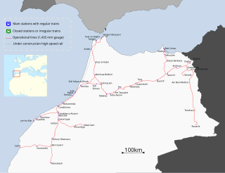
ONCF is Morocco's national railway operator. ONCF is a state-owned company that is under the control of the Ministry of Equipment, Transport and Logistics and is responsible for all passenger and freight traffic on the national railway network. The company is also responsible for building and maintaining the rail infrastructure.
In Morocco, the 75 second-level administrative subdivisions are 13 prefectures and 62 provinces. They are subdivisions of the 12 regions of Morocco. Each prefecture or province is subdivided into arrondissements, municipalities or urban municipalities in other urban areas, and districts in rural areas. The districts are subdivided into rural municipalities. One prefecture (Casablanca) is also subdivided into préfectures d'arrondissements, similar to districts (cercles) except they are grouping a few arrondissements instead of rural municipalities.

The Cairo–Dakar Highway or TAH 1 is Trans-African Highway 1 in the transcontinental road network being developed by the United Nations Economic Commission for Africa (UNECA), the African Development Bank (ADB), and the African Union. The major part of the highway between Tripoli and Nouakchott has been constructed under a project of the Arab Maghreb Union.

Rail transport in Morocco is operated by the national railway operator ONCF. It was initially developed during the protectorate.

Tangier's economy is the third biggest of all Moroccan cities, after the economic capital Casablanca and the city of Fez. Tangier is Morocco's second most important industrial center after Casablanca. The industrial sectors are diversified: textile, chemical, mechanical, metallurgical and naval. Currently, the city has four industrial parks of which two have the status of free economic zone.

The N2 road is a national road in Morocco which connects Tangier in the northwest of the country with Oujda in the Northeast.

National Route 6 (N6) is a national highway of Morocco. It is one of the most important road networks linking the west of the country to the east, connecting the capital Rabat and Salé on the west coast to Maghnia, Algeria on the border. It passes through many of Morocco's major cities such as Oujda, Fes, Meknes and Khemisset. For much of the Fes- Rabat leg is runs parallel with the A2 Rabat–Fes expressway.

National Route 16 (N16) is a national highway of Morocco. It connects Tangier on the northwest coast of Morocco to Saidia on the northeast coast. It is an important highway running along the northern Middeteranean coast of the country. It passes through Tetouan, Al Houceima and other important cities.
The N1 or National Highway 1 is a national highway in Ghana that begins at the border with Ivory Coast at Elubo and runs through Sekondi-Takoradi, Cape Coast, Winneba, Accra and Tema to the border with Togo at Aflao. It is the main highway along the coast of the country, with a total distance of 540 kilometers. The route runs through the Western, Central, Greater Accra and Volta regions of Ghana.

Guelmim-Oued Noun is one of the twelve regions of Morocco. The southeastern part of the region is located in the disputed territory of Western Sahara and a small strip of land in this area is administered by the Sahrawi Arab Democratic Republic. The region as a whole covers an area of 46,108 km2 and had a population of 433,757 as of the 2014 Moroccan census. The capital of the region is Guelmim.
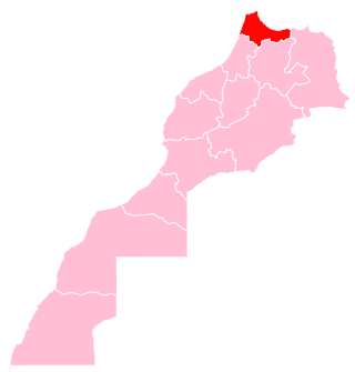
Tangier-Tetouan-Al Hoceima is the northernmost of the twelve regions of Morocco. It covers an area of 15,090 km2 and recorded a population of 3,556,729 in the 2014 Moroccan census. The capital of the region is Tangier.

National Route 1 (N1) is a primary national route that forms part of the Philippine highway network, running from Luzon to Mindanao. Except for a 19-kilometer (12 mi) gap in Metro Manila and ferry connections, the highway is generally continuous. Most sections of N1 forms the Pan-Philippine Highway except for sections bypassed by expressways.

The Embassy of the Philippines in Rabat is the diplomatic mission of the Republic of the Philippines to the Kingdom of Morocco. It is currently located in the Souissi neighborhood of southern Rabat, near the Finnish, Norwegian and Russian embassies. Although the current embassy dates from 2019, the Philippines maintained a previous resident embassy in Morocco from 1979 to 1986, and again from 1990 to 1993.