There are around 56,986 km (35,409 mi) of roads in Morocco. In addition to 1,808 km (1,123 mi) of highways.

The N1 is a national route in South Africa that runs from Cape Town through Bloemfontein, Johannesburg, Pretoria and Polokwane to Beit Bridge on the border with Zimbabwe. It forms the first section of the famed Cape to Cairo Road.

The R61 is a long provincial route in South Africa that connects Beaufort West with Port Shepstone via Graaff-Reinet, Komani, Mthatha and Port Edward.

Morocco's network of motorways is administered by the state-owned company Autoroutes du Maroc (ADM). It runs the network on a pay-per-use basis, with toll stations placed along its length. The general speed limit is 120 km/h.

The Casablanca–Rabat expressway, designated A1, was the first expressway to be built in Morocco, with construction starting in the 1970s. It was only completed in 1986 after a 7-year halt.

The Rabat–Tangier-Med expressway is an expressway in Morocco. It begins in Morocco's capital of Rabat, and connects to the northern port of Tanger-Med. The expressway's identity marker is "A5".

The Rabat–Fes expressway is an expressway in Morocco; its designated identity marker is A2. Its total length is 190 km.

The N2 is a national route in South Africa that runs from Cape Town through George, Gqeberha, East London, Mthatha, Port Shepstone and Durban to Ermelo. It is the main highway along the Indian Ocean coast of the country. Its current length of 2,255 kilometres (1,401 mi) makes it the longest numbered route in South Africa.

The M3 is an expressway in Cape Town, South Africa, connecting the upper part of the City Bowl to the Southern Suburbs and ending in Tokai. For most of its route it parallels - though further to the south and west - the M4, which was the original road connecting central Cape Town with the settlements to the south.
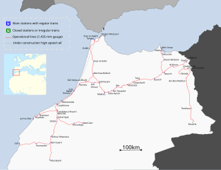
ONCF is Morocco's national railway operator. ONCF is a state-owned company that is under the control of the Ministry of Equipment, Transport and Logistics and is responsible for all passenger and freight traffic on the national railway network. The company is also responsible for building and maintaining the rail infrastructure.

The Société Nationale des Autoroutes du Maroc (ADM) is Morocco's national authority for the management of over 1400+ km of Moroccan expressways. ADM is based in Rabat.

Rail transport in Morocco is operated by the national railway operator ONCF. It was initially developed during the protectorate.

State Highway 2 runs north–south through eastern parts of the North Island of New Zealand from the outskirts of Auckland to Wellington. It runs through Tauranga, Gisborne, Napier, Hastings and Masterton. It is the second-longest highway in the North Island, after State Highway 1, which runs the length of both of the country's main islands.

The Casa-Voyageurs Railway Station is an ONCF station in the Belvedere neighborhood of Casablanca.
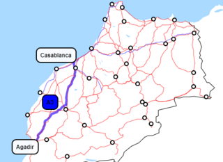
The Autoroute Casablanca–Agadir is a new main road in Morocco. Building began in 2000 and the road was inaugurated on 21 June 2010 by Prince Moulay Rachid.

The city of Nador in Morocco has two railway-stations: Nador Ville and Nador South. Further on the line there is also a station at Beni Anşār / Aït Nsar and the terminal Beni Anşār / Aït Nsar Port, which is generally indicated as Nador Port station. As with all railway stations in Morocco, these stations are operated by ONCF, Morocco's national railway operator.

National Route 6 (N6) is a national highway of Morocco. It is one of the most important road networks linking the west of the country to the east, connecting the capital Rabat and Salé on the west coast to Maghnia, Algeria on the border. It passes through many of Morocco's major cities such as Oujda, Fes, Meknes and Khemisset. For much of the Fes- Rabat leg is runs parallel with the A2 Rabat–Fes expressway.

National Route 1 (N1) is a national highway of Morocco. It connects Guerguerat in the south near the border with Mauritania to Tangier on the northwest coast of Morocco. It is an important highway running along the western Atlantic coast of the country. It passes through Rabat, Larache and other important cities and for a substantial part of the Rabat-Tangier leg runs parallel with the A1 Rabat–Tangier expressway. It is the longest national motorway in the country.

The Rabat Ring Road or Rabat Bypass is a Moroccan expressway around the capital Rabat.
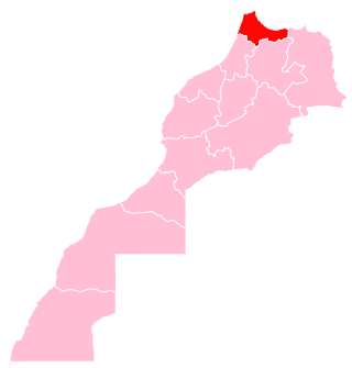
Tangier-Tetouan-Al Hoceima is the northernmost of the twelve regions of Morocco. It covers an area of 15,090 km2 and recorded a population of 3,556,729 in the 2014 Moroccan census. The capital of the region is Tangier.