Morocco, officially the Kingdom of Morocco, is a country in the Maghreb region of North Africa. It overlooks the Mediterranean Sea to the north and the Atlantic Ocean to the west, and has land borders with Algeria to the east, and the disputed territory of Western Sahara to the south. Morocco also claims the Spanish exclaves of Ceuta, Melilla and Peñón de Vélez de la Gomera, and several small Spanish-controlled islands off its coast. It has a population of approximately 37 million. Islam is both the official and predominant religion, while Arabic and Berber are the official languages. Additionally, French and the Moroccan dialect of Arabic are widely spoken. The culture of Morocco is a mix of Arab, Berber, African and European cultures. Its capital is Rabat, while its largest city is Casablanca.

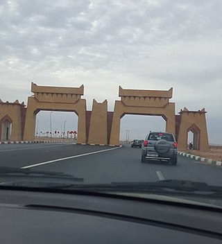
There are around 56,986 km (35,409 mi) of roads in Morocco. In addition to 1,808 km (1,123 mi) of highways.
Transport in Western Sahara is very limited by sea, road and air with camels being the primary means of transportation in the desert area. Road transport by buses remain the major mode of transportation. The longest conveyor belt in the world is 100 kilometres (62 mi) long, from the phosphate mines of Bu Craa to the coast south of Laayoune. The belt moves about 2,000 metric tons of rock containing phosphate every hour from the mines to El-Aaiun, where it is loaded and shipped.

The Atlas Mountains are a mountain range in the Maghreb in North Africa. It separates the Sahara Desert from the Mediterranean Sea and the Atlantic Ocean; the name "Atlantic" is derived from the mountain range, which stretches around 2,500 km (1,600 mi) through Morocco, Algeria and Tunisia. The range's highest peak is Toubkal, which is in central Morocco, with an elevation of 4,167 metres (13,671 ft). The Atlas Mountains are primarily inhabited by Berber populations.

The Arab world, formally the Arab homeland, also known as the Arab nation, the Arabsphere, or the Arab states, comprises a large group of countries, mainly located in West Asia and North Africa. While the majority of people in the Arab world are ethnically Arab, there are also significant populations of other ethnic groups such as Berbers, Kurds, Somalis and Nubians, among other groups. Arabic is used as the lingua franca throughout the Arab world.

Ancash is a department and region in western Peru. It is bordered by the departments of La Libertad on the north, Huánuco and Pasco on the east, Lima on the south, and the Pacific Ocean on the west. Its capital is the city of Huaraz, and its largest city and port is Chimbote. The name of the region originates from the Quechua word anqash, from anqas ('blue') or from anka ('eagle').

Essaouira, known until the 1960s as Mogador, is a port city in the western Moroccan region of Marrakesh-Safi, on the Atlantic coast. It has 77,966 inhabitants as of 2014.

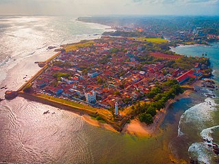
Galle is a major city in Sri Lanka, situated on the southwestern tip, 119 km (74 mi) from Colombo. Galle is the provincial capital and largest city of Southern Province, Sri Lanka and is the capital of Galle District.

Trans-Saharan trade is trade between sub-Saharan Africa and North Africa that requires travel across the Sahara. Though this trade began in prehistoric times, the peak of trade extended from the 8th century until the early 17th century CE. The Sahara once had a different climate and environment. In Libya and Algeria, from at least 7000 BCE, pastoralism, large settlements and pottery were present. Cattle were introduced to the Central Sahara (Ahaggar) between 4000 and 3500 BCE. Remarkable rock paintings in arid regions portray flora and fauna that are not present in the modern desert.

Morocco's network of motorways is administered by the state-owned company Autoroutes du Maroc (ADM). It runs the network on a pay-per-use basis, with toll stations placed along its length. The general speed limit is 120 km/h.

Guelmim is a city in southern Morocco, often called Gateway to the Desert. It is the capital of the Guelmim-Assif Noun region which includes southern Morocco and the northeastern corner of Western Sahara. The population of the city was 187,808 as of the 2014 Moroccan census, making it the largest city in the region. The N1 and N12 highways cross at Guelmim and link it to the nearby region of Souss-Massa.

Khenifra is a city in northern central Morocco, surrounded by the Atlas Mountains and located on the Oum Er-Rbia River. National Highway 8 also goes through the town. The population, as of a 2019 census, was 228,567.

Taounate is a town in northern Morocco, and is the capital of Taounate Province. The town had 37,616 inhabitants as of the 2014 Moroccan census.

Inezgane is the capital of Inezgane-Aït Melloul Prefecture located on the north bank of the Sous River, about 11.5 km (7.1 mi) south of Agadir, on the Atlantic Ocean coast of Morocco. It is in some ways a suburb to the larger Agadir, but unlike the tourism-centered Agadir, Inezgane is a typical Moroccan city. Located where the N1, N8 and N10 highways meet, Inezgane is an important transport hub in the region of Souss-Massa. The record of the highest temperarures in Inezgane, 51.7 °C, is disputed.

Umayyad Square is a large and important square in Damascus, Syria. It connects the city center with several important highways and areas, and contains important buildings, including the Ministry of Defense, Syria's national Opera House and the headquarters of the Syrian Armed Forces.

Casablanca is a port city on the Atlantic coast of western Morocco. Casablanca is Morocco's biggest city, principal port, and economic capital. The town of Casablanca was founded in 1515. It was an important strategic port during World War II and hosted the Anglo-American Summit in 1943. The city is served by Mohammed V International Airport. Casablanca covers the richest and most sophisticated aspects of Morocco life, style, and architecture. Casablanca boasts one of the most extensive and diverse displays of art deco architecture in the world.

National Route 6 (N6) is a national highway of Morocco. It is one of the most important road networks linking the west of the country to the east, connecting the capital Rabat and Salé on the west coast to Maghnia, Algeria on the border. It passes through many of Morocco's major cities such as Oujda, Fes, Meknes and Khemisset. For much of the Fes- Rabat leg is runs parallel with the A2 Rabat–Fes expressway.

National Route 8 (N8) is a national highway of Morocco. It is one of the most important road networks running through mid-central Morocco. It links with National Route 1 in Inezgane, a southern suburb of Agadir near the Atlantic coast to the central mountainous area of the country. The highway passes through cities such as Chichaoua, Marrakech, Beni Mellal, Khenifra, Fez, and the ski resort in the Atlas Mountains, Ifrane. At Marrakech it connects with the National Route 9.

National Route 1 (N1) is a national highway of Morocco. It connects Guerguerat in the south near the border with Mauritania to Tangier on the northwest coast of Morocco. It is an important highway running along the western Atlantic coast of the country. It passes through Rabat, Larache and other important cities and for a substantial part of the Rabat-Tangier leg runs parallel with the A1 Rabat–Tangier expressway. It is the longest national motorway in the country.


