Related Research Articles

Burhanpur is a historical city in the Indian state of Madhya Pradesh. It is the administrative seat of Burhanpur District. It is situated on the north bank of the Tapti River and 512 kilometres (318 mi) northeast of city of Mumbai, 340 kilometres (211 mi) southwest of the state's capital city of Bhopal. The city is a Municipal Corporation.

Panipat is a historic city, located in Haryana, India. It is 95 km north of Delhi and 169 km south of Chandigarh on NH-1. The three major battles fought in 1526, 1556 and 1761 took place near the city. The city is famous in India as the "City of Weavers" and "Textile City". It is also known as the "cast-off capital" due to being "the global centre for recycling textiles". Panipat is also home to a variety of manufacturing industries including wool and cotton milling, saltpetre refining, and the manufacture of glass, electrical appliances, and other products. Panipat is included in the list of Critically Polluted Industrial Areas in India. The Comprehensive Environment Pollution Index (CEPI) of the city is 71.91 as against 88.50 of Ankaleshwar (Gujarat). The fatal field of Panipat is the site of three battles that changed the course of India's history, resulting in the creation and confirmation of the Mughal Empire. The third battle led to the decisive defeat of the Maratha Confederacy in North India, which became a dominating power in Delhi by then and paved the way for the British colonial rule of India.
The Kharoti (Pashto:خروٹی) خروټی) are a Pashtun tribe of Ghilji origin, originating in the central part of Paktika Province, Afghanistan, but can be also found in other parts of the country. The Kharoti settled in Kharotabad in Quetta, British India around 1945.

Sheikhupura also known as Qila Sheikhupura, is a city and district in the Pakistani province of Punjab. Founded by the Mughal Emperor Jahangir in 1607, Sheikhupura is the 16th largest city of Pakistan by population and is the headquarters of Sheikhupura District. The city is an industrial centre and satellite town, and is located about 38 km northwest of Lahore. It also borders Sialkot, Gujranwala, Nankana Sahib and Kasur districts of Punjab, Pakistan.

Maham Anga was the foster mother and chief wet nurse of the Mughal emperor Akbar. She was the political adviser of the teenage emperor and the de facto regent of the Mughal Empire from 1560 to 1562.
Kharan district is a district in the Balochistan province of Pakistan.

The Baluchistan States Union or Balochistan States Union (BSU) was an administrative division of Pakistan that existed between 3 October 1952 and 14 October 1955 in the southwestern part of West Pakistan. It was formed by the four princely states of Kalat, Kharan, Las Bela and Makran with the capital at the town of Kalat. The area of the Union was roughly the south-western half of the modern province of Balochistan. The Union was separate from the Chief Commissioners Province of Baluchistan which comprised areas to the northeast of the Union. The Union did not include the enclave of Gwadar which was part of the Muscat and Oman. The four state rulers continued in office and retained autonomy.
The Khanate of Kalat was a Brahui Khanate that originated in the modern-day Kalat region of Pakistan. Formed in 1666 due to the threat of Mughal expansion in the region, it controlled the wider Balochistan at its greatest extent in the mid-18th century, extending from Kerman in the west to Sindh in the east and from Helmand river in the north to the Arabian sea in the south. The Khanate of Kalat lost considerable area to Qajar Iran and the Emirate of Afghanistan in the early 19th century, and the city of Kalat was itself sacked by the British in 1839. Kalat became a self-governing state in a subsidiary alliance with British India after the signature of the Treaty of Kalat by the Khan of Kalat and the Baloch Sardars in 1875, and the supervision of Kalat became a task of the Baluchistan Agency. Kalat was briefly independent from 12 August 1947 until 27 March 1948, when its ruler Ahmad Yar Khan acceded to Pakistan, making it one of the Princely states of Pakistan.

Aonla is a town, also a proposed district and a municipal board in Bareilly district in the state of Uttar Pradesh, India.
The Rakshan River rises at the Nidoki pass, south-west of Shireza, district Washuk, Balochistan, Pakistan.
Parom is a Tehsil in Panjgur District in Balochistan, Pakistan. The historical area of Parom was divided by the Goldsmith line, thus a small part of it falls in Iranian territory. According to local legend, it was also known as Gulshan, meaning 'rose garden'. The word parom means 'growth' in the Balochi language and is attributed to Parom due to its mild climate and the fertile soil which supports more than one crop per year. Today the region has two union councils, Parom and Koh Bun. The population numbers around 50,000 people.
Hajib Shakarbar was born as the younger of the two sons of Shams Tabrizi and Shams Sabzwari in 1213 AC. His grand parents named him Alauddin Muhammad, but when his father returned from Tabriz to see his newborn baby, he changed the name from Alauddin Muhammad to Syed Ahmad because he had a dream to this effect in Tabriz. The new baby showed the signs of a born Hafiz and so came to be known as Zinda Pir from his very infancy. He got the title of Shakarbar in Sabzwar and of Hajib in Makkah, and became so famous with the sweet combination of Hajib Shakarbar that his original names went into total oblivion. He joined his father in Multan, Pakistan, with his elder brother Naseeruddin, and a large armed escort of Turkish, Iraqi and Kabul fighters in 1289 AC.
Chagai-II is the codename assigned to the second atomic test conducted by Pakistan, carried out on 30 May 1998 in the Kharan Desert in Balochistan Province of Pakistan. Chagai-II took place two days after Pakistan's first successful test, Chagai-I, which was carried out on 28 May 1998 in the Ras Koh area in Chagai District, Balochistan, Pakistan.
Sardar Charat Singh, also romanised as Charhat Singh, was the founder of Sukerchakia Misl and father of Mahan Singh, and the grandfather of Ranjit Singh. He distinguished himself at an early age in campaigns against Ahmad Shah Abdali and along with 150 horsemen split from the Singhpuria Misl to establish the Sukerchakia Misl.

The princely states of Pakistan were princely states of the British Indian Empire which acceded to the new Dominion of Pakistan between 1947 and 1948, following the partition of British India and its independence.
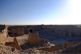
Nikoderian Tombs, also known as Mashkel Tombs, are Towers of Silence located in Balochistan, Pakistan. These are ancient burial grounds of the Zoroastrians dating back to 800 AD. The present day site is an archaeological site spread between the towns of Nag and Panjgur. The towers were made of burnt bricks and are adorned with various human, animal and mythological figures.

The tomb of the noble Isa Khan Niazi is located in the Humayun's Tomb complex in Delhi, India. The mausoleum, octagonal in shape and built mainly of red sandstone, was built in 1547–1548 during the reign of Sher Shah Suri. The mosque of Isa Khan is located west of the mausoleum, which along with other buildings form the UNESCO World Heritage Site of Humayun's tomb complex.
References
- ↑ "Naushervani tombs". The Express Tribune. September 12, 2011.
- ↑ The third khan, Nikodar, the son of Hulako, who was styled Ahmad Khan [ permanent dead link ]