Naval Auxiliary Landing Field Orange Grove

Last updated

Coordinates: 27°54′04″N098°03′06″W / 27.90111°N 98.05167°W / 27.90111; -98.05167

Geographic coordinate system Coordinate system

A geographic coordinate system is a coordinate system that enables every location on Earth to be specified by a set of numbers, letters or symbols. The coordinates are often chosen such that one of the numbers represents a vertical position and two or three of the numbers represent a horizontal position; alternatively, a geographic position may be expressed in a combined three-dimensional Cartesian vector. A common choice of coordinates is latitude, longitude and elevation. To specify a location on a plane requires a map projection.

NALF Orange Grove
Summary
Airport type Military
Owner United States Navy
Location Jim Wells County, near Orange Grove, Texas
Elevation  AMSL 257 ft / 78 m
Map
USA Texas location map.svg
Airplane silhouette.svg
NOG
Runways
Direction Length Surface
ft m
1/19 8,000 2,438 PEM
13/31 8,000 2,438 PEM

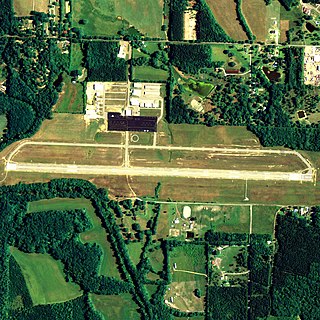
Naval Auxiliary Landing Field Orange Grove or NALF Orange Grove( ICAO : KNOG, FAA LID : NOG) is a military airport located southwest of Orange Grove, a city in Jim Wells County, Texas, United States. It was commissioned in 1951, and covers an area of 1,373 acres (5.56 km2). Owned by the United States Navy, it supports pilot training for NAS Kingsville. It has two runways, 1/19 and 13/31, each measuring 8,000 x 200 ft (2,438 x 61 m). [1] [2]

ICAO airport code four-letter code designating many airports around the world

The ICAOairport code or location indicator is a four-letter code designating aerodromes around the world. These codes, as defined by the International Civil Aviation Organization and published in ICAO Document 7910: Location Indicators, are used by air traffic control and airline operations such as flight planning.

Federal Aviation Administration United States Government agency dedicated to civil aviation matters

The Federal Aviation Administration (FAA) is a governmental body of the United States with powers to regulate all aspects of civil aviation in that nation as well as over its surrounding international waters. Its powers include the construction and operation of airports, air traffic management, the certification of personnel and aircraft, and the protection of U.S. assets during the launch or re-entry of commercial space vehicles. Powers over neighboring international waters were delegated to the FAA by authority of the International Civil Aviation Organization.

A location identifier is a symbolic representation for the name and the location of an airport, navigation aid, or weather station, and is used for manned air traffic control facilities in air traffic control, telecommunications, computer programming, weather reports, and related services.

Although most U.S. airports use the same three-letter location identifier for the FAA and IATA, NALF Orange Grove is assigned NOG by the FAA but has no designation from the IATA [3] (which assigned NOG to Nogales International Airport in Nogales, Sonora, Mexico [4]

International Air Transport Association trade group of airlines

The International Air Transport Association is a trade association of the world’s airlines. Consisting of 290 airlines, primarily major carriers, representing 117 countries, the IATA's member airlines account for carrying approximately 82% of total available seat miles air traffic. IATA supports airline activity and helps formulate industry policy and standards. It is headquartered in Montreal, Quebec, Canada with Executive Offices in Geneva, Switzerland.

Nogales International Airport (Mexico) airport in Heroica Nogales, Mexico

Nogales International Airport is an international airport located at Nogales, Sonora, Mexico, near the U.S.-Mexico border. It handles national and international air traffic for the city of Nogales. It is operated by Aeropuertos y Servicios Auxiliares, a federal government-owned corporation.

Nogales, Sonora City in Sonora, Mexico

Heroica Nogales, more commonly known as Nogales, is a city and the county seat of the Municipality of Nogales. It is located on the northern border of the Mexican state of Sonora. The city is abutted on its north by the city of Nogales, Arizona, across the U.S.-Mexico border.

Related Research Articles

Naval Air Station Whiting Field – South, also known as South Whiting Field, is located three miles (5 km) north of the central business district of Milton, in Santa Rosa County, Florida, United States. This military airport is owned by the US Navy. It is one of two airfields located at Naval Air Station Whiting Field, the other airfield being NAS Whiting Field – North.

New Century AirCenter airport in Kansas, United States of America

New Century AirCenter, formerly known as Naval Air Station Olathe, Flatley Field and Johnson County Industrial Airport, is a joint civil-military general aviation airport located four miles (6 km) southwest of the central business district of Olathe, a city in Johnson County, Kansas, United States.

Little River Airport airport in California, United States of America

Little River Airport is a small county-owned public-use airport located three nautical miles southeast of the central business district of Little River, in Mendocino County, California, United States.

Aurora Municipal Airport Illinois

Chicago/Aurora Municipal Airport is a public airport opened in April 1966, located in the village of Sugar Grove, Illinois, United States, 8 miles (13 km) west of the city of Aurora, both in Kane County. The airport is owned and operated by the City of Aurora. It is 50 miles (80 km) west of Chicago and is designated as a reliever airport for Chicago's O'Hare and Midway airports.

Naval Outlying Field San Nicolas Island or NOLF San Nicolas Island is a military airport located on San Nicolas Island, in Ventura County, California. The airport is administered by Naval Base Ventura County and is one of several Naval Outlying Landing Fields operated by the US Navy.

NOG or Nog may refer to:

Flagler County Airport airport in Florida, United States of America

Flagler County Airport is a county-owned public-use airport located three miles (5 km) east of the central business district of Bunnell, a city in Flagler County, Florida, United States. The airport's former FAA location identifiers were X47 and XFL. The airfield was originally constructed by the United States Navy during World War II as Naval Outlying Field Bunnell , an auxiliary airfield for flight training operations originating from nearby Naval Air Station Jacksonville, NAS Daytona Beach and NAS DeLand. Following the end of the war, the airfield was transferred from the Navy to Flagler County for use as a general aviation airport.

Grand Prairie Municipal Airport airport in Texas, United States of America

Grand Prairie Municipal Airport is a city-owned public-use airport located four miles (6 km) southwest of the central business district of Grand Prairie, a city largely in Dallas County, Texas, United States.

Houston Southwest Airport airport in Texas, United States of America

Houston Southwest Airport or Houston-Southwest Airport is a public-use airport located in Arcola, a city in Fort Bend County, Texas, United States, 15 miles (24 km) southwest of the central business district of Houston. It is privately owned by James Griffith, Jr.

Avon Park Executive Airport airport in Florida, United States of America

Avon Park Executive Airport is a city-owned, public-use airport located two nautical miles (3.7 km) west of the central business district of Avon Park, a city in Highlands County, Florida, United States.

Walker County Airport airport in Alabama, United States of America

Walker County Airport, also known as Bevill Field, is a public airport located five miles (8 km) northwest of the central business district of Jasper, a city in Walker County, Alabama, United States. It is owned by the Walker County Commission.

Sylacauga Municipal Airport airport in Alabama, United States of America

Sylacauga Municipal Airport, also known as Merkel Field, is a city-owned public-use airport located three nautical miles west of the central business district of Sylacauga, a city in Talladega County, Alabama, United States. It is included in the FAA's National Plan of Integrated Airport Systems for 2011–2015, which categorized it as a general aviation facility.

George M. Bryan Airport airport in Mississippi, United States of America

George M. Bryan Airport is a public use airport in Oktibbeha County, Mississippi, United States. It is owned by the City of Starkville and located three nautical miles (6 km) southwest of its central business district. This airport is included in the National Plan of Integrated Airport Systems for 2011–2015, which categorized it as a general aviation facility.

Naval Outlying Field Summerdale airport in Alabama, United States of America

Naval Outlying Field Summerdale is a military use airport located in Summerdale, a town in Baldwin County, Alabama, United States. It is under the operational control of NAS Whiting Field and is used for flying training.

Tokeen Seaplane Base airport in Alaska, United States of America

Tokeen Seaplane Base is a public use seaplane base located in Tokeen, in the Prince of Wales-Hyder Census Area in the U.S. state of Alaska.

Burnet Municipal Airport airport in Texas, United States of America

Burnet Municipal Airport, also known as Kate Craddock Field, is a city-owned public-use airport located one nautical mile (1.85 km) southwest of the central business district of Burnet, a city in Burnet County, Texas, United States.

Naval Auxiliary Landing Field Ford Island

Naval Auxiliary Landing Field Ford Island was a military use airport on the Island of Oahu, Hawaii, United States. Prior to 1962, it was designated as Naval Air Station Ford Island until its downgrade from NAS to NALF. It continues to be owned by the United States Navy and is located six nautical miles (11.1 km) northwest of the central business district of the City of Honolulu on Ford Island. NALF Ford Island was closed as an active airfield on 1 July 1999, but still remains part of the Naval Base Pearl Harbor complex.

Clarence E. Page Municipal Airport airport in Oklahoma, United States of America

Clarence E. Page Municipal Airport is a city-owned public-use airport located in Canadian County, Oklahoma, United States. It is 15 nautical miles (28 km) west of the central business district of Oklahoma City, but still within its city limits. This airport is included in the FAA's National Plan of Integrated Airport Systems (2009–2013), which categorizes it as a general aviation airport.

Naval Auxiliary Landing Field Fentress airport in Virginia, United States of America

Naval Auxiliary Landing Field Fentress is a military use airport located in Chesapeake, Virginia. This military airport is owned by the U.S. Navy and is under the operational control of Naval Air Station Oceana, Virginia. The airfield primarily supports day and night Field Carrier Landing Practice (FCLP) operations by US Navy and US Marine Corps F/A-18 Hornet, and US Navy F/A-18 Super Hornet, E-2 Hawkeye and C-2 Greyhound aircraft based in Virginia and the Carolinas.

Orange County Airport (Virginia) airport in Virginia, USA

Orange County Airport is a county-owned, public-use airport in Orange County, Virginia, United States. It is located three nautical miles (6 km) east of the central business district of Orange, Virginia. This airport is included in the National Plan of Integrated Airport Systems for 2011–2015, which categorized it as a general aviation facility.

References

  1. 1 2 FAA Airport Master Record for NOG ( Form 5010 PDF ), effective 2007-12-20
  2. Airfield Condition Survey: NALF Orange Grove, June 2003 (DOC)
  3. KNOG - NALF Orange Grove - Orange Grove, Texas at Great Circle Mapper
  4. NOG / MMNG - Nogales International Airport - Nogales, Sonora, México at Great Circle Mapper).