Gulf Breeze is a city in Santa Rosa County, Florida. It is a suburb of Pensacola, and is in the Pensacola Metropolitan Area. The population was 6,302 in 2020.

Sleeping Bear Dunes National Lakeshore is a U.S. national lakeshore in the northwestern Lower Peninsula of Michigan. Located within Benzie and Leelanau counties, the park extends along a 35-mile (56 km) stretch of Lake Michigan's eastern coastline, as well as North and South Manitou islands, preserving a total of 71,199 acres. The park is known for its outstanding natural features, including dune formations, forests, beaches, and ancient glacial phenomena. The lakeshore also contains many cultural features, including the 1871 South Manitou Island Lighthouse, three former stations of the Coast Guard, and an extensive rural historic farm district.

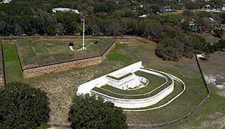
Fort Pickens is a pentagonal historic United States military fort on Santa Rosa Island in the Pensacola, Florida, area. It is named after American Revolutionary War hero Andrew Pickens. The fort was completed in 1834 and was one of the few forts in the South that remained in Union hands throughout the American Civil War. It remained in use until 1947. Fort Pickens is included within the Gulf Islands National Seashore, and as such, is administered by the National Park Service.

The Florida panhandle is the northwestern part of the U.S. state of Florida. It is a salient roughly 200 miles (320 km) long, bordered by Alabama on the north and the west, Georgia on the north, and the Gulf of Mexico to the south. Its eastern boundary is arbitrarily defined. It is defined by its southern culture and rural geography relative to the rest of Florida, as well as closer cultural links to French-influenced Louisiana, Mississippi, and Alabama. Its major communities include Pensacola, Navarre, Destin, Panama City Beach, and Tallahassee.

Poison Springs Battleground State Park is an Arkansas state park located southeast of Bluff City. It commemorates the Battle of Poison Spring in the American Civil War, which was part of the 1864 Camden Expedition, an element of a Union Army initiative to gain control of Shreveport, Louisiana and get a foothold in Texas.

Gascoigne Bluff is a bluff next to the Frederica River on the western side of the island of St. Simons, Georgia which was a Native American campground, the site of a Franciscan monastery named San Buenaventura, and the site of the Province of Georgia's first naval base.

Gulf Islands National Seashore is an American National seashore that offers recreation opportunities and preserves natural and historic resources along the Gulf of Mexico barrier islands of Florida and Mississippi. In 2022, it was the eighth-most visited unit of the National Park Service.
Fort Barrancas (1839) or Fort San Carlos de Barrancas is a United States military fort and National Historic Landmark in the former Warrington area of Pensacola, Florida, located physically within Naval Air Station Pensacola, which was developed later around it.

Perdido Key is an unincorporated community in Escambia County, Florida located between Pensacola, Florida and Orange Beach, Alabama. The community is located on and named for Perdido Key, a barrier island in northwest Florida and southeast Alabama. "Perdido" means "lost" in the Spanish and Portuguese languages. The Florida district of the Gulf Islands National Seashore includes the east end of the island, as well as other Florida islands. No more than a few hundred yards wide in most places, Perdido Key stretches some 16 miles (26 km) from near Pensacola to Perdido Pass Bridge near Orange Beach.

The maritime history of Florida describes significant past events relating to the U.S. state of Florida in areas concerning shipping, shipwrecks, and military installations and lighthouses constructed to protect or aid navigation and development of the Florida peninsula.
The Fairpoint Peninsula, also referred to as the Gulf Breeze Peninsula or the Navarre Peninsula or historically the Santa Rosa Peninsula, is located in northwest Florida between Santa Rosa Sound and Pensacola Bay.

Fort Massachusetts is a fort on West Ship Island along the Mississippi Gulf Coast of the United States. It was built following the War of 1812, with brick walls during 1859–1866, and remained in use until 1903. Currently, it is a historical tourist attraction within the Gulf Islands National Seashore. The fort is located about halfway along the north shore of West Ship Island, near a boat pier.

The Florida Trail is one of eleven National Scenic Trails in the United States. It currently runs 1,500 miles (2,400 km), from Big Cypress National Preserve to Fort Pickens at Gulf Islands National Seashore, Pensacola Beach. Also known as the Florida National Scenic Trail, the Florida Trail provides permanent non-motorized recreation opportunity for hiking and other compatible activities and is within an hour of most Floridians. The Florida National Scenic Trail is designated as a National Scenic Trail by the National Trails System Act of 1968.
Oriole Beach is an unincorporated community located in Santa Rosa County, Florida, United States on Santa Rosa Sound. It lies east of Gulf Breeze on the Fairpoint Peninsula, and about three miles north of Pensacola Beach. Oriole Beach is part of the Pensacola–Ferry Pass–Brent Metropolitan Statistical Area.

The Pensacola metropolitan area is the metropolitan area centered on Pensacola, Florida. It is also known as the Pensacola-Ferry Pass-Brent Metropolitan Statistical Area, a metropolitan statistical area (MSA) used for statistical purposes by the United States Census Bureau and other agencies. The Pensacola Standard Metropolitan Statistical Area was first defined in 1958, with Pensacola as the principal city, and included Escambia and Santa Rosa counties. The SMA was renamed Pensacola-Ferry Pass-Brent MSA in 2003, with the unincorporated census-designated places Ferry Pass and Brent added as principal cities. The population of the MSA in the 2020 census was 511,502.
Grover Island is an island located near the mouth of Crooked River in Camden County, Georgia. The island has over 400 acres (1.6 km2) of forest and about 1,600 acres (6 km2) of connected salt marsh and small waterways. Grover Island is four miles (6 km) west of Cumberland Island National Seashore. It was the site of the United States' first national forest preserve.

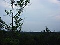
The First American Road in Florida is a historic road near Gulf Breeze, Florida. It is located in the Naval Live Oaks Area of the Gulf Islands National Seashore.
The Naval Live Oaks Cemetery is a prehistoric cemetery associated with the Pensacola culture, a regional variant of the Mississippian culture. It is located near Gulf Breeze, Florida. On September 28, 1998, it was added to the U.S. National Register of Historic Places.
North Florida, sometimes shortened to NorFlo, is a region of the U.S. state of Florida comprising the northernmost part of the state. Along with South Florida and Central Florida, it is one of Florida's three most common "directional" regions. It includes Jacksonville and nearby localities in Northeast Florida, an interior region known as North Central Florida, and the Florida Panhandle.