
State Route 513 (SR 513) is a 3.35-mile-long (5.39 km) state highway in the U.S. state of Washington, located entirely within the city of Seattle in King County. The highway travels north as Montlake Boulevard from an interchange with SR 520 and over the Montlake Bridge to the University of Washington campus in the University District. SR 513 continues past University Village before it turns northeast onto Sand Point Way and ends at the entrance to Magnuson Park in the Sand Point neighborhood.
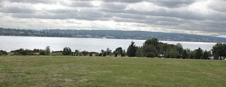
Magnuson Park is a park in the Sand Point neighborhood of Seattle, Washington, United States. At 350 acres (140 ha) it is the second-largest park in Seattle, after Discovery Park in Magnolia. Magnuson Park is located at the site of the former Naval Station Puget Sound, on the Sand Point peninsula with Pontiac and Wolf bays that juts into Lake Washington in northeast Seattle.

Carkeek Park is a 216 acres (87 ha) park located in the Broadview neighborhood of Seattle, Washington. The park contains Piper Orchard, Pipers Creek, play and picnic areas, picnic shelters, and hiking trails. A pedestrian bridge across the main lines of the BNSF Railway connects to the Carkeek Park sand beach on Puget Sound. Park program activities are largely out of the Carkeek Park Environmental Learning Center.

Sand Point is a neighborhood in Seattle, Washington, United States, named after and consisting mostly of the Sand Point peninsula that juts into Lake Washington, which is itself largely given over to Magnuson Park. Its southern boundary can be said to be N.E. 65th Street, beyond which are Windermere and Hawthorne Hills; its northern boundary, N.E. 95th Street, beyond which is Lake City. The western limit of the neighborhood, beyond which are View Ridge and Wedgwood, is not fixed and can be said to be anywhere up the hill that extends west from Sand Point Way N.E. as far as 35th Avenue N.E. It is also the former home of Seattle Naval Air Station.

Naval Air Station Alameda was a United States Navy Naval Air Station in Alameda, California, on San Francisco Bay.

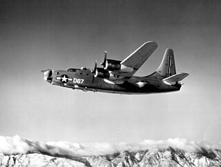
The Consolidated PB4Y-2 Privateer is an American World War II and Korean War era patrol bomber of the United States Navy derived from the Consolidated B-24 Liberator. The Navy had been using B-24s with only minor modifications as the PB4Y-1 Liberator, and along with maritime patrol Liberators used by RAF Coastal Command this type of patrol plane was proven successful. A fully navalized design was desired, and Consolidated developed a dedicated long-range patrol bomber in 1943, designated PB4Y-2 Privateer. In 1951, the type was redesignated P4Y-2 Privateer. A further designation change occurred in September 1962, when the remaining Navy Privateers were redesignated QP-4B.

Arlington Municipal Airport is a public airport located three miles (5 km) southwest of the central business district of Arlington, a city in Snohomish County, Washington, United States. It is owned and operated by the City of Arlington.

Johnston Island Air Force Base is a former United States Air Force base on the Johnston Atoll in the United States Minor Outlying Islands, in the Pacific Ocean several hundred kilometers southwest of Hawaii. After its closure, it briefly operated as Johnston Atoll Airport, until that also closed in 2005.

DeLand Municipal Airport, also known as Sidney H. Taylor Field, is a city-owned public-use airport located three nautical miles (5 km) northeast of the central business district of DeLand, a city in Volusia County, Florida, United States.

VP-23, Patrol Squadron 23, known as the Seahawks, was a U.S. Navy fixed-wing, anti-submarine and maritime patrol squadron based at Brunswick Naval Air Station, Brunswick, Maine, United States. It was established as Weather Reconnaissance Squadron Three (VPW-3) on 17 May 1946, redesignated as Meteorology Squadron Three (VPM-3) on 15 November 1946, redesignated Heavy Patrol Squadron (Landplane) Three (VP-HL-3) on 8 December 1947, and to Patrol Squadron Twenty Three (VP-23) on 1 September 1948 and disestablished on 28 February 1995. It was the second squadron to be designated VP-23, the first VP-23 was redesignated Patrol Bombing Squadron 23 (VPB-23) on 1 October 1944 and disestablished on 25 January 1946.
Naval Air Station DeLand was a United States Naval Air Station located in DeLand, Florida from 1942 to 1946. After the war, the airfield and associated infrastructure was redeveloped into DeLand Municipal Airport.
Patrol Squadron 24 (VP-24) was a Patrol Squadron of the U.S. Navy. The squadron was established as Bombing Squadron One Hundred Four (VB-104) on 10 April 1943, redesignated as Patrol Bombing Squadron One Hundred Four (VPB-104) on 1 October 1944, redesignated as Patrol Squadron One Hundred Four (VP-104) on 15 May 1946, redesignated Heavy Patrol Squadron (Landplane) Four (VP-HL-4) on 15 November 1946, redesignated Patrol Squadron Twenty Four (VP-24) on 1 September 1948, the third squadron to be assigned the VP-24 designation, redesignated Attack Mining Squadron Thirteen (VA-HM-13) on 1 July 1956, redesignated Patrol Squadron Twenty Four (VP-24) on 1 July 1959 and disestablished 30 April 1995.

Holtville Airport is a county-owned, public-use airport located five nautical miles (9 km) northeast of the central business district of Holtville, a city in Imperial County, California, United States. Holtville was a U.S. Navy airfield during World War II.
Nukufetau Airfield is a former World War II airfield on the south-eastern side of Nukufetau on Motulalo Island in Tuvalu during the Pacific War.
NASA Crows Landing Airport is a private use airport owned by the NASA Ames Research Center, 1 nautical mile northwest of the central business district of Crows Landing, in Stanislaus County, California, United States. The airfield was formerly named Naval Auxiliary Landing Field Crows Landing or NALF Crows Landing when operated by the U.S. Navy. In January 2011, Airport-data.com reported the airport status as closed permanently. In March 2022, Stanislaus County announced the former airfield would be redeveloped into a business park.
Alan C. Carey is an American author and historian who specializes in military aviation topics.
VP-123 was a Patrol Squadron of the U.S. Navy. The squadron was established as Bombing Squadron 140 (VB-140) on 21 April 1943, redesignated Patrol Bombing Squadron 140 (VPB-140) on 1 October 1944, redesignated Patrol Bombing Squadron 123 (VPB-123) on 20 November 1944, redesignated Patrol Squadron 123 (VP-123) on 15 May 1946 and disestablished on 1 October 1946.
VP-HL-3 was a Heavy Patrol Squadron (Landplane) of the U.S. Navy. The squadron was established as Bombing Squadron 138 (VB-138) on 15 March 1943, redesignated Patrol Bombing Squadron 138 (VPB-138) on 1 October 1944, redesignated Patrol Bombing Squadron 124 (VPB-124) on 15 December 1944, redesignated Patrol Squadron 124 (VP-124) on 15 May 1946, redesignated Heavy Patrol Squadron (Landplane) 3 (VP-HL-3) on 15 November 1946 and disestablished on 22 May 1947.
VP-HL-5 was a Heavy Patrol Squadron (Landplane) of the U.S. Navy. The squadron was established as Bombing Squadron 143 (VB-143) on 15 June 1943, redesignated Patrol Bombing Squadron 143 (VPB-143) on 1 October 1944, redesignated Patrol Squadron 143 (VP-143) on 15 May 1946, redesignated Heavy Patrol Squadron (Landplane) 5 (VP-HL-5) on 15 November 1946 and disestablished on 27 May 1947.
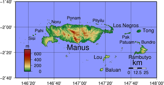
Manus Naval Base was a number of bases built after the World War II Battle of Manus by United States Navy on the Manus Island and a smaller island just east, Los Negros Island in the Admiralty Islands chain. The major naval base construction started with the Los Negros landings on February 28, 1944. The Navy repaired and did the expansion of the airfields on the Admiralty Islands. United States Navy Seabee built or repaired the facilities on the islands. The large Manus Naval Base, also called the Admiralty Island base, supported United States Seventh Fleet, Southwest Pacific command, and part of the Pacific Fleet. The base was abandoned by the US Navy after the war.


